GC3T367 Unknown Cache Colorado Thirteener Challenge
Type: Mystery | Size: Regular Regular | Difficulty: 3 out of 5 | Terrain: 4.5 out of 5
By: ernie66 @ | Hide Date: 08/04/2012 | Status: Available
Country: United States | State: Colorado
Coordinates: N39° 25.395 W106° 07.372 | Last updated: 08/30/2019 | Fav points: 0
Takes more than an hour  Scenic view  Significant hike  Difficult climbing  Abandoned mines  Cliff / falling rocks  Dangerous area  Parking available  Long Hike (+10km) 

Colorado Thirteener Challenge

Congratulations to RDAD - First to Find!

This is a challenge cache. The cache is at the listed coordinates, but you must meet the specific requirements below before logging this cache.

Colorado is well-known for its 53 peaks above 14,000 feet with more than 300 feet of prominence known as "fourteeners." Thousands flock each summer to these summits and on some there is barely room to sit because of the number of climbers crowding the high point. This cache isn't about those peaks.

Instead, it's about the less-well-known "thirteeners," peaks whose summits don't quite break the 14,000 foot mark. We have climbed a number of these and look back on these hikes as some of our favorites. It is rare to see another person at or near the top of a thirteener, even on a Saturday in August. In celebration of our 20th finds in this elevation range, we invite you to experience some less-travelled Colorado high country.

Mt. Elbert 14,433

Pacific Peak 13,950

In order to qualify for this cache, you must find and sign the physical logs of ten (10) distinct caches whose elevations are between 13,000 and 13,999 feet above sea level. This bookmark list courtesy of A & J Adrift includes, among others, all currently-active eligible caches in Colorado and documents their elevations using the USGS 1/3 arc-second NED database.

The Rules:

  • You must find 10 distinct caches whose elevations are between 13,000 and 13,999 feet.
  • Only caches located in the state of Colorado may be counted.
  • Only traditional, letterbox, and multi-caches whose final container is in the eligible elevation range may be used.
  • This cache may not be used as one of your 10 qualifying caches.
  • Second and subsequent finds of any cache may not be counted.
  • A find of a cache you own may not be counted.
  • Your log must list the ten caches you are counting, their elevations, your find date, and the method used to determine the cache's elevation.
  • Previous finds and finds of caches that have subsequently been archived may be counted.
  • You may visit the cache and sign the physical log without qualifying, but you must meet the qualifications before entering a Found-it log online.
  • The cache owners retain final authority in case of dispute.

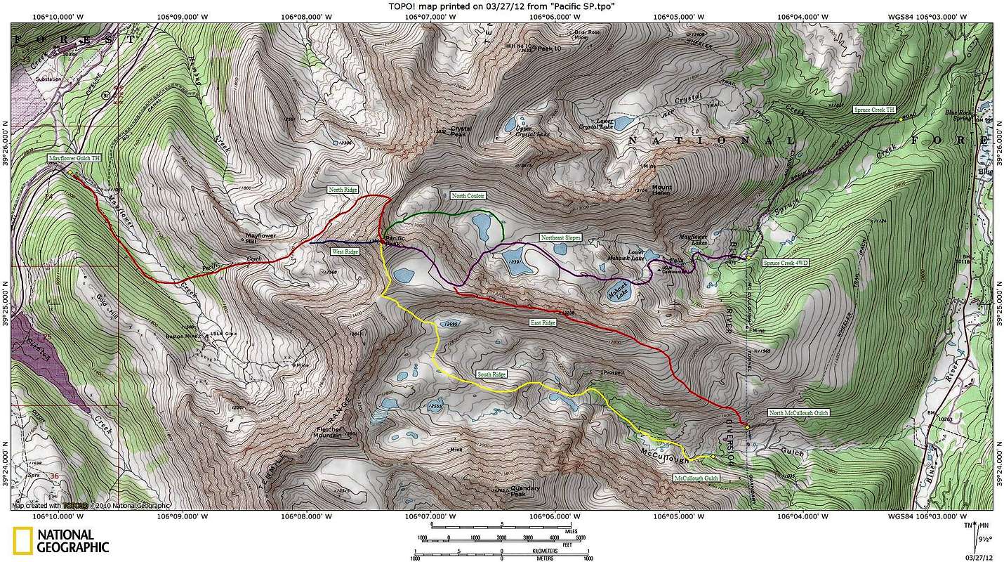
The cache is located near the summit of Pacific Peak at an elevation of 13,950. Plan on a significant hike to reach the cache. Documented routes exist from the Spruce Creek/Mohawk Lakes Trailhead (northeast slopes), McCullough Gulch Trailhead (south ridge), and the Boston Mine (west ridge and north ridge), among others. All routes are at least Class 2+.

Print and bring the spoiler photo with you. The cache is an ammo can between two larger rocks approximately 60 feet at bearing 115 true from the summit.


Click map for larger version

Additional Waypoints

PA3T367 - Boston Mine Road Parking
N 39° 25.120 W 106° 09.220
Parking for West Ridge and North Ridge routes
PB3T367 - McCullough Gulch Parking
N 39° 24.060 W 106° 04.750
Parking for South Ridge route
PC3T367 - Spruce Creek 4WD Parking
N 39° 25.290 W 106° 04.510
Parking for Northeast Slopes route
 Custom URLs

Add cache to watch list
Log your visit
Picture Gallery

 Additional Waypoints (3)

CodeNameTypeCommentsDateCoordinatesDistance
PA3T367Boston Mine Road Parking Parking Area Parking for West Ridge and North Ridge routes 08/06/2012 N 39° 25.120 W 106° 09.220 2.69 kms W 
PB3T367McCullough Gulch Parking Parking Area Parking for South Ridge route 08/06/2012 N 39° 24.060 W 106° 04.750 4.50 kms SE 
PC3T367Spruce Creek 4WD Parking Parking Area Parking for Northeast Slopes route 08/06/2012 N 39° 25.290 W 106° 04.510 4.10 kms E 

 Nearby Caches

GC3RYPQ Transcontinental Ridge - Atlantic Peak (1.14 kms S)
GC31H55 -TwoCs- Sunrise Point (aka Stairway to P (8.10 kms NE)
GC2CWHH LSP&L North London Mill Switchback (15.53 kms S)
GC2CWH9 LSP&L Climb to North London Mill (15.98 kms S)
GC2CWH0 LSP&L Orphan Boy Mine (16.49 kms S)


Driving Directions

 Logs

5 Logs: Found it 3  Write note 2  

Write note 08/09/2015 By Alexsummit
I just wanted to say wow to all you guys I have summited about 20 13ers but it was before I knew about geocaching! I will hopefully be able complete this challenge someday!

Write note 07/08/2015 By animjason
I did a few 13ers with jsarche on Monday so I decided to take a look and see if I qualify for this awesome challenge. And I DO! And what is even more awesome, I have exactly 13 caches at 13k feet. Here are my qualifiers, I will make this a smiley once I come do the hike.

GC2DCDD 66rand Central Elbert (13962.9) on 8/31/13
GC2CM5F Thirteen Nine (13824.8) on 6/27/12
GC15B77 Pikes Peak Marathon (13783.3) on 7/14/11
GC4M64N Mt Elbert, Near The Top (13694.9) on 9/5/13
GC141HG Kelso Ridge Scramble (13397.8) on 7/30/11
GC576EP Kellie and Juli's Pink on the Peak (13353.0) on 8/2/14
GC141HF Stevens Gulch Overlook (13309.7) on 8/19/10
GC5AVD0 Sniktau (13203.5) on 7/6/15
GC2FGAV Solitude above the Cirque (13116.8) on 8/17/11
GC55D9 Pikes Peak Traveler (13108.9) on 8/17/11
GC5AVCA 4000 on Little Sniktau (13095.1) on 7/6/15
GC3P4HQ I'm No Angel (13083.8) on 7/6/15
GC572VX Bridget (13008.5) on 8/2/14

Found it 07/22/2014 By A & J - Adrift
Elevation is from USGS 1/3 arc-second NED database. The caches are from our list of high caches we've done.

1) 08/16/2013 GC2DCDD 66rand Central Elbert 13,963'
2) 07/13/2008 GC158C8 Archer's Friend (Fletcher Mountain) 13,942'
3) 07/14/2014 GC4J9JR Point 13832 13,829'
4) 07/22/2014 GC3RYPQ Transcontinental Ridge - Atlantic Peak 13,823'
5) 07/14/2014 GC4J9KG Point 13811 13,822'
6) 08/16/2013 GC14CJT Bull Hill 13,768'
7) 08/18/2013 GC2AP35 Sport's Ptarmigan Peak 13,730'
8) 06/12/2013 GC4DK7P Cottonwood Peak 13,595'
9) 07/22/2014 GC3PTFM Pacific lake 13,583'
10) 08/18/2013 GC2AP3Y Sport's Shelter Stash 13,581'

You're right about the 13ers. We were alone on top of Pacific. But, we could look across and see the continuous stream of traffic on top of Quandary.

Found it 12/22/2013 By Denali41
I've climbed many, many 13ers over the years, but almost all were summited before the advent of geocaching. So there are a bunch of delicious caches out there atop 13ers that have some real appeal and will necessitate reclimbs. I now have 10 caches that I've gotten to since this challenge cache whetted my appetite again for climbs in this elevation range. They are listed in the attached image. I also own 6 caches on mountains having elevations within this range. They await your climbs/finds!

Thanks, ernie66, for this nice challenge! I enjoyed my hike up Pacific Peak to the cache site on a July day that sported beautiful weather. As is the norm when a 13er is the target, I had the whole area all to myself--never saw another person the entire outing!

Found it 09/07/2013 By estes01
A very worthy challenge. My most memorable hikes were not 14ers, but 13ers. Apparently I've hiked 51 of them since I've started caching...the majority of them with ernie66. Some were more memorable than others. I've attached my favorites.