GC778VF Letterbox Hybrid K Tracker's Middle Finger
Type: Letterbox | Size: Large Large | Difficulty: 3.5 out of 5 | Terrain: 4.5 out of 5
By: K Trackers @ | Hide Date: 06/13/2017 | Status: Available
Country: United States | State: Colorado
Coordinates: N38° 57.151 W104° 54.754 | Last updated: 08/30/2019 | Fav points: 0
Not Recommended for kids  Takes more than an hour  Scenic view  Not Recommended at night  Cliff / falling rocks  Special Tool Required  Medium hike (1km-10km)  Seasonal Access 

As my first "wilderness" cache, I am proud to present K Tracker's Middle Finger (KMF)

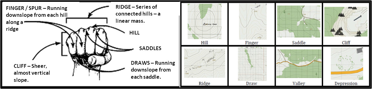
Finger. fin•ger \'fi?-g?r\
noun
1. A military slang term for a spur; a terrain feature consisting of a short, continuous sloping line of higher ground, normally jutting out from the side of a ridge. A spur is often formed by two rough parallel streams, which cut draws down the side of a ridge. The term derives from a US Army technique of using the hand to teach soldiers terrain features.
2. A protruding digit or appendage, most often associated with each of the four slender jointed parts attached to the human hand.

Depending on your interpretation of the terrain, you may be inspired by one or more of these definitions.

The KMF cache is a three stage Letterbox Hybrid (1. posted coordinates, 2. waypoint 1, 3. final location). The final container has the unique and highly coveted "KMF" stamp. BYOP and BYOIP (Bring Your Own Ink Pad)

The cache is on a finger between ("in the middle") the draw containing the Blodgett trail and the spur with the extended Hummingbird trail network of the Blodgett Peak Open Space. The Final GZ is near a little used secondary trail and in an area that experienced Blodgett hikers may find new or little visited. Please properly prepare for terrain and weather conditions typical for this part of the Rocky Mountains. Note the listed attributes. Due to safety concerns, do not attempt the cache during periods of snow and ice.

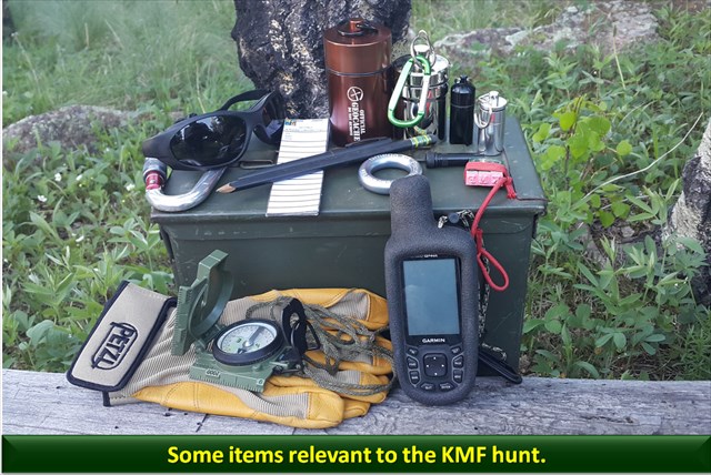
Although the total distance from all stages is not significant, some may find the terrain difficult. The container at the posted coordinates will provide navigation instructions to Waypoint 1. These instructions will require a digital tool (e.g. GPS), analog tool (e.g. compass) and/or natural navigation skills to follow a distance and direction / project a waypoint. Tweezers are also recommended in case cachers do not repack the waypoints properly over time. Waypoint 1 will include a standard lat / long to the Final Location (GZ).

Enjoy the hike and hunt.

Additional Waypoints

FN778VF - Final Location
N/S __ ° __ . ___ W/E ___ ° __ . ___

W1778VF - Waypoint 1
N/S __ ° __ . ___ W/E ___ ° __ . ___

 Custom URLs

Add cache to watch list
Log your visit
Picture Gallery

 Hints

Posted: Micro near the base of the finger. Sticks out like a "sore thumb," even though a thumb is not a finger.
Waypoint 1: Micro within 10 feet of the finger. On a metal finger.
Final: Large finger container in the middle of organic stuff on the finger.

 Nearby Caches

GC778XD The Old Geocacher and the Sea (0.21 kms E)
GC4E78C Try Bimbo Pie! (11.62 kms SE)
GC2Y6WH Stubs In The Tree (14.74 kms S)
GCJPR4 Baldy's Base (20.54 kms S)
GC7R6C9 Section16_AR_Cache (21.70 kms E)


Driving Directions

 Logs

5 Logs: Found it 5  

Found it 11/05/2017 By THeSKuLL
Got back up this way to try to find this one. It was difficult to get to for my old/broke body, but we got there and made the find after some searching and scrambling. Excellent container! The log was a bit damp. Thanks for the fun.

Found it 10/05/2017 By KJKlock
Found this one with THeSKuLL. It was a gorgeous day to get out for a hike. We found all stages in good condition. When we finally made it to the final, we celebrated our success. The views were awesome. Beautiful location.

Found it 07/17/2017 By COpackrat
Stopped by on my way along the ridge today - thanks for bringing me to this interesting area!

Found it 07/01/2017 By ernie66
Estes01 accompanied me but we used a different route from her first time. No shorter, but a lot less elevation gain. As we approached from Rd 302, the terrain got successively rougher, becoming nearly impassable near the first stop due to steepness, loose rock, and heavy brush. But I made the find there and proceeded on with the second stop and ultimately on up to the final cache. Thanks for putting another cache along the ridgetop - it's been a while since I've been up here. TFTC!

Found it 06/26/2017 By estes01
Well the first thing I have to say is thank you for the adventure and getting me in condition for this summer's more challenging caches. The second thing that comes to mind is that if your middle finger looks like that rock, I wouldn't be advertising it. WingsAndTales and I made your new caches way more challenging than was necessary as we thought the other route was closed. The third thing is the most important...the coords for the first stop were about 70 feet off for me. This is not really a problem as most can find the next finger anyway:-) As always, an imaginative K Trackers cache! Thanks for the fun and for the exercise!