Rocky
Mountain (RM) Off Road Series (ORS) #14: Chinaman
Gulch
A series by
Team
Red Rubicon members: RocketMan,
zoltig,
taylorsgeotracker,
Red
Ruby, Mountain
Roamer, n0wae,
QueenZelda & Cub Boy, and jpit
.
This cache is the first of seven in the
#14 series of Rocky Mountain off-road caches located along the
difficult Chinaman Gulch Trail. The Chinaman Gulch Trail
starts out just south-east of Buena Vista. This trail is
somewhat challenging and should only be attempted if you have the
right vehicle and some off roading experience. This trail can
easily be done on foot also, so if your vehicle is not equipped,
you can still do the series (a full trail description is included
below).
Cache
Information
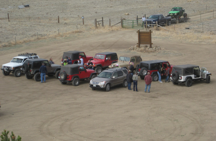
This cache is perched above the
air down/staging area with a good view of the surrounding
area. There is plenty of room at the staging area to leave
your Jeep and/or ATV trailers and to park vehicles to air down the
tires. You will enter through two gates just before the
staging area. Make sure you close the gates back up after
your enter.
RM Off Road Series #14
Compete Cache Listing
1.
Air Down
2.
Rock Garden
3.
Rock Pile
4.
Whales Tail
5.
The Stairs
6.
The Chutes
7.
Got View
?
Trail Information
Rating/Description
Chinaman Gulch trail is one of the premier difficult trails in
Colorado
. Because of the relatively low elevation of this trail
(7,832 to 8,904 feet), it can typically be run very early and very
late in the season when all of the higher trails are closed or
impassable because of snow. If you are up for a bit of a
challenge and want to test your vehicle, this trail is a good one
to do and it's a blast. It has many rocky areas to negotiate
and numerous named obstacles. From the
staging area, the trail runs for approximately 1.7 miles before
you reach "the loop". You should turn right to run the loop
in the recommended counterclockwise direction, returning back to
the same point after completing the loop. After completing
the loop, you will return the way you came in by going back down
the trail along the same 1.7 mile stretch.
This trail is
rated difficult and many of the obstacles do not have a bypass so
you must negotiate them.
It is rated a 4 (easiest routes) to 7 (most
difficult routes) out of 10 on the traildamage
website.
Team Red Rubicon
members believe that the trail should be rated more like a
6-8. Disclaimer: You need to decide for yourself if
it is safe to make the trip in your vehicle and if you have any
doubts, don't do it.
The trail has the following named
obstacles (most of the caches in this series are at the
obstacles):
Rock Garden - On the way to the loop.
Lots of rocks to test your flex and ground clearance.
Rock Pile - Optional pile of rocks (what else) to test your
vehicle.
Whales Tail - A small rock waterfall you must climb. Has
three approaches that are extreme, difficult and less
difficult.
The Stairs - Optional obstacle. Extreme on the left and a bit
easier on the right.
The Chutes - A V-notch that is not optional.
Note: You will find a more detailed descriptions of these obstacles
on the namesake cache pages (see links above).
To get to the trailhead, head south on
CR-301 from US 24 at N38 48.872 W106 05.970. Stay on CR-301
for approximately 1.6 miles and then go left at N38 47.507 W106
05.698. There is a gate at this point that you must open and
then close behind you. You will go approximately 0.4 miles to
the staging area N38 47.529 W106 05.129, passing through a second
gate just before the staging area. From the staging area, you
will head almost directly north on the Chinaman Gulch trail.
The trailhead is at N38 47.556 W106 05.144. Note: If you head
east from the staging area instead of north, you will be headed for
Carnage Canyon. Unless you have an extreme rock buggy, stay
away from that trail.
Note: All coordinates in
the above description are included on the waypoint list
below.
Winter
Months
As stated previously, because this trail is at a relatively low
elevation, it can often be run very early to very late in the
season. Chinaman Gulch is generally accessible to off road
vehicles from late April though late November although conditions
can vary greatly from year to year.
Time/Distance
The trail is 7.3 miles from the start at the staging area until
you get back to the staging area. You will spend some time at
each obstacle, so the trail will typically take about 5 or 6 hours
if you aren't trying to hurry. Make sure you leave some extra
time to have lunch on the trail, find the caches and to do some
exploring. To reach the trailhead from the Denver area takes
about 2.5 to 3 hours so leave the house early.
Trail
Waypoints
See waypoint list below.
Additional Waypoints
W11QY6B - Head South Here
N 38° 48.872 W 106° 05.970
Head south on CR-301 from US 24 at this point. Travel 1.6 miles to get to the next waypoint where you will turn left.
W21QY6B - Turn Left
N 38° 47.507 W 106° 05.698
Turn left here and got through the gate. Travel 0.4 miles to a second gate and the staging area.
W31QY6B - Staging Area
N 38° 47.529 W 106° 05.100
This is the location of the air down/staging area.
W41QY6B - Chinaman Gulch Trailhead
N 38° 47.556 W 106° 05.144
Start of the Chinaman Gulch trail.
W51QY6B - Bear Right
N 38° 47.731 W 106° 05.100
Bear right here and head up the hill.
W61QY6B - Go Left
N 38° 47.694 W 106° 04.459
Go left here. Right will take you down Carnage Canyon. You can drive part way down if you just want to check out the insanity.
W71QY6B - Optional Viewpoint to Left
N 38° 48.015 W 106° 04.639
If you take a left here, you can go to an optional viewpoint. Return here to continue the Chinaman Gulch Trail.
W81QY6B - Start of Loop
N 38° 48.206 W 106° 04.676
Turn right here to start the loop. You will end up back at this point when you complete the loop and return the way you came in.
 RM ORS #14-01 Air Down
 | Difficulty:
  | Terrain:


