|
GC6RC20
 The Spearhead, A Glacial Horn
Type: Earth | Size: Other  | Difficulty:
  | Terrain:
 By: msstrong @ | Hide Date: 09/02/2016 | Status: Available Country: United States | State: Colorado Coordinates: N40° 15.452 W105° 38.281 | Last updated: 08/30/2019 | Fav points: 0 


")
This is a fee area of the National Park Service. The park is open 24 hours a day, 365 days a year. Glaciers not only transport material as they move, but they also sculpt and carve away the land beneath them. A glacier's weight, combined with its gradual movement, can drastically reshape the landscape over hundreds or even thousands of years. The ice erodes the land surface and carries the broken rocks and soil debris far from their original places, resulting in some interesting glacial land formations. 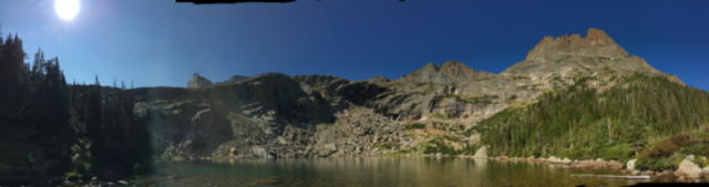 One of these formations is called a "horn", A pyramid-shaped mountain peak created as multiple glaciers erode away at the same mountain. Can you identify "The Spearhead" in this photo? The topographic map below contains the horn called "Spearhead". Horns will form when two or more glaciers erode back into the same mountain peak and leave a portion of the mountain in place between them. 
Clues to help identify a horn include the presence of at least two cirques, whether they contain glaciers or not, and closed contour lines that are closely spaced. The Spearhead (12,575-ft) resides in the heart of Glacier Gorge, Rocky Mountain National Park. Overshadowed by a skyline of shapely peaks, The Spearhead is actually an extension of rugged ridge running north from the base of Chiefs Head Peak’s huge north face. The Spearhead’s triangular northeast face is the dominant feature in upper Glacier Gorge, (the area above Black Lake) rendering this special area a local name of “Spearhead Basin.” The unbroken, flowing slabs of granite rock set it a part from its higher neighbors. Many would argue that this is the most spectacular summit in the park and one of the best in all of Colorado. 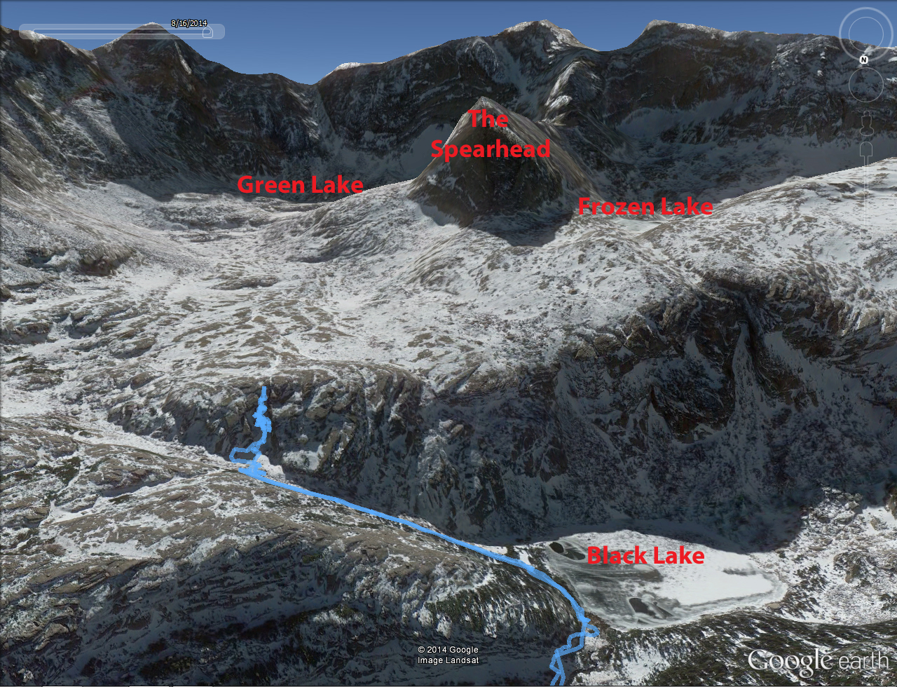 The Matterhorn in Switzerland (as in the photo to the left) is a perfect example of a glacial horn. You can hike all the way to the top of the Spearhead as shown on the topo above. (The give coordinates for this EarthCache will take you to the base of the Spear Head). Parking is located at the Glacier Gorge Trailhead, or you can park at one of the several shuttle bus parking lots and take the shuttle to the trailhead. The given coordinates will lead you on a 6.5 mile hike with over 2500 ft. of elevation gain to the base of the Spearhead (13 miles round trip) and a nice spot to have lunch and admire a rare formation. To get credit for this Earthcache send me the answer to the following questions. 1. The area you are standing on is at a location at the base of the spearhead, take an elevation reading and subtract it from the peak elevation of the spearhead (12,575') and tell me how high this cliff is. 2. Examine the erosion process of the cliff face, do you think something comes off of the cliff face every year? 3. From the given coordinates look up the cliff face about 100', what do you see? 4. Look above the 100' line, do you think the cliff face will erode at the same rate as below the 100' line? Why? 5. How do you think the cliff face will continue to erode? By "peeling" layers off like an onion or break away in different shapes or both? What geological force or forces do think will make this happen? 6. From the given coordinates look back down at the screed field and into the basin, this is a huge cliff face, why do you think there is such a small screed field? 7. On your way back down stop and look back at the face of the cliff about 100' up, what amazing change in the formation do you see? How thick do you think it is? What is different about what you see? Do you think is made up of the same material as the rest of the spearhead? 8. As you hike out of this valley and back to the trail head, look at the ridge line on your left and right, do you see any other possible "glacial horns" in this valley? Looking to the east at the long sloping flat ridge you see the west side of Longs Peak. Additional Waypoints P06RC20 - parkingN 40° 18.636 W 105° 38.414 T06RC20 - Mills lake/ Black lake N 40° 18.636 W 105° 38.414 The Trail Head is next to the restrooms
Add cache to watch list Log your visit Picture Gallery
GC15HQ6 In 'Plane' View (15.66 kms SE) GCGVW7 One of Two (16.08 kms NW) GC15HQ7 Rocky Road Rest Rocks (16.34 kms SE) GCA9JWA Germany meets Rocky Mountains / PART II (17.00 kms NE) GC4MG7G Would I pull your leg? (19.28 kms E) |
Driving Directions
5 Logs:
|