|
GC8ZJ2G
 A Navigational Challenge for KT--6
Type: Mystery | Size: Small  | Difficulty:
  | Terrain:
  By: Denali41 @ | Hide Date: 08/22/2020 | Status: Available Country: United States | State: Colorado Coordinates: N40° 13.166 W105° 24.014 | Last updated: 06/19/2022 | Fav points: 0 


")

I have a new email friend whom I call “KT”. That’s not my new email acquaintance’s actual name, but it will do. KT emailed me claiming to be an excellent navigator. Of course effective navigation requires multifaceted skills, including knowing where to find and how to use salient map and other resources needed to determine possible routes to a destination--and from these options to chose the optimal route plus the tools needed to calculate coordinates and to achieve the destination of the cache hide. Recent episodes suggest that KT could benefit by refining his/her navigational skills, so I have developed several scenarios that can serve as checkpoints in establishing a reasonable portfolio of expertise. This is the sixth scenario. It is preceded and will be followed by others that employ additional facets of navigational techniques. The cache descriptions are not “instructional”; instead, they provide opportunities for the cache seeker to explore navigational solutions to attain success in calculating and getting to a cache’s coordinates. For those seekers who already possess the basic skills, developing a plan to reach each of the caches should be straight forward. Begin at the listed coordinates. They take you to a place that is relatively close to the picturesque natural arch shown in the photo, below. Natural arches of this sort are quite unusual in this region, and seeing this one in the field is worth the hike in and of itself! The natural arch can be found by walking a bearing of 275 degrees from the listed coordinates. You will need to walk several hundred feet to find it. Keep your eyes searching for the arch! Have fun locating and then admiring the arch! 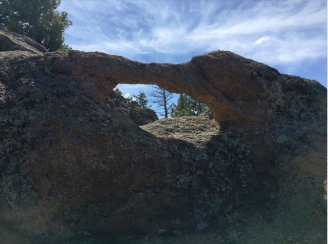 ~The Natural Arch~ ~The Natural Arch~Once you locate the arch stand at its center and take accurate coordinates. Determine the exact location of the cache using these instructions: The cache is located 325.42 m from the arch. The arch is located at a bearing of 948.27 mils from the cache. You now have all the information needed to find the cache, so go find it! Have an enjoyable hike and a successful “find” of the cache. The navigational challenge of determining useful cache coordinates and determining the best route combined with the hiking distance and elevation gain provide a good back country geocaching adventure. Have a great time! Additional Waypoints
Add cache to watch list Log your visit Picture Gallery
GC2DXE0 Mountain Micro #1 - Hound Dog Rock (13.07 kms SE) GC2DX51 switzerland trail on other side of road (18.86 kms S) GC2DXA4 Primos Mondos Semillos (23.70 kms S) GC6PJ6Z Roadside Railing (25.01 kms SE) GC2DWJD Where Are You #1 (26.01 kms SE) |
Driving Directions
3 Logs:
|