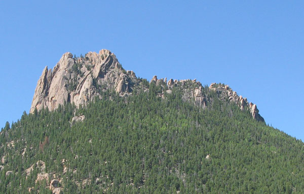
GC1VQY5 Traditional Cache Castle's Back Door
Type: Traditional | Size: Regular Regular | Difficulty: 2.5 out of 5 | Terrain: 4.5 out of 5
By: JMKR and Joe W @ | Hide Date: 07/17/2009 | Status: Available
Country: United States | State: Colorado
Coordinates: N39° 18.743 W105° 22.897 | Last updated: 08/30/2019 | Fav points: 0
Access or parking fee  Not Recommended for kids  Takes more than an hour  Scenic view  Difficult climbing  Cliff / falling rocks  Thorns  Medium hike (1km-10km) 

Significant route-finding and off-trail hiking/scrambling are required to reach this cache. Pre-plan your mission well and be prepared!
Many people see the photogenic Castle from the front side.  A few make the technical climb to the top.  Almost no one visits the towers and valleys of the back side ... but you will if you seek this cache.

The Castle from the north

Cache location is on the northwest side of the Castle, just outside the Lost Creek Wilderness.  An honest ammo can awaits you at the end of this trek, along with a fine view.

View from the cache site

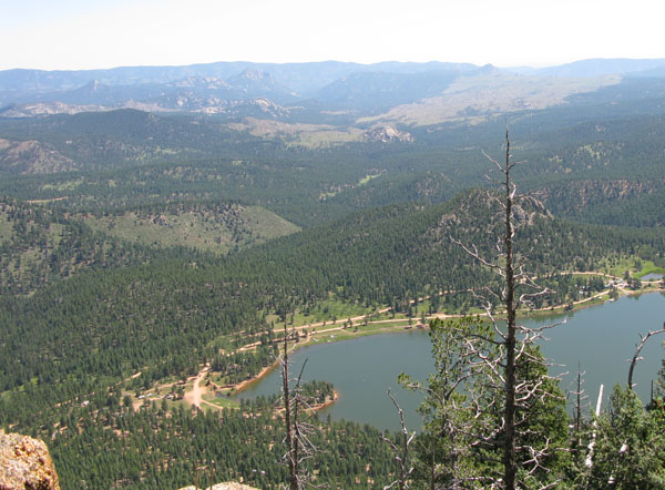
No technical rock climbing needed if you approach from the south, just a lot of scrambling and bushwacking.  The terrain is rough and hiking solo is not recommended.  Do not attempt to pioneer a direct route from the north without climbing gear and experience!

Allow a half day to a full day depending on your route and level of conditioning.  The scenery will make up for at least some of the pain.  Topo map(s) and compass are absolutely essential since you will be off-trail in rough terrain.  Two possible ways of getting here:

  1. Pay to enter the Wellington Lake recreation area located at the intersection of FS 543 and 560.  (Search "Castle Mountain Recreation" for access info)  Drive around the lake to the parking area for the waterfall trail.  Hike up to the ridgeline and then around the back side of the Castle.
  2. Hike south along the Rolling Creek trail from the Colorado Trail junction near the Wellington Lake road.  Enter the Lost Creek Wilderness then work your way up to the Castle from the southwest.
Either way, expect tough going due to slopes, boulders, deadfall, and bushes.  We paid in blood and sweat (no tears) and you probably will also.  Cache is placed at approx 9400 ft, which is a 1400 ft gain from the Wellington Lake parking area.  Final approach from the south is through a very pleasant valley.

For additional info about the climb to the Castle's peak, read Colorado's Lost Creek Wilderness: Classic Summit Hikes by the Roaches or search SummitPost trip reports.

We're hoping that you have a tale and/or photo to share of your trek.  Enjoy the journey and be safe!

Visit Castle's Back Door on LonelyCache.com

 Custom URLs

Add cache to watch list
Log your visit
Picture Gallery

 Hints

Under a rock of course

 Nearby Caches

GC14ECE Beaver Ranch Fitness calf-stretch (23.03 kms N)
GC14ED3 Beaver Ranch Dog-gone fitness trail (23.07 kms N)
GC1E966 Colorado Spirit Quest #39 Foxton/Beaver (23.11 kms N)
GC9XBEV The Evergreen Outback (27.41 kms N)
GC8AY74 SSJ Pt. 4 Attack of the dog bones (27.80 kms N)


Driving Directions

 Logs

5 Logs: Found it 4  Write note 1  

Found it 06/18/2018 By JozinUK
Wow! Like has been previously said - don't underestimate the hike to this cache. Awesome view! Cache is in great condition. Thanks!

Found it 09/21/2012 By flint_9
I'm not going to lie. I was a little bit cocky about this geocache. WARNING: Do not be cocky about this geocache!!!!!! LOL I came up camping with my girlfriend for our 2-year anniversary at Wellington lake. She was nice enough to let me do this on that day. I went up from the west along the castle trail for a while and then went off on my own trail. I don't know if I went a weird way or what but on a scale of 1-5 I would give the way I went a 11. I did go solo but took a walkie (which does not work the majority of the way since you're on the back-side of the castle). I would say do not go solo, take plenty of water and a victory snack for the top. Also, make sure to leave early enough to get back by sunset. All-in-all I was 3 hours up and 2 hours back but I would make sure to give yourself at least 8-9 hours to be on the safe side. Well worth the pain though. Signed log. I took the boy scout carabiner and left 4 wheat pennies in cases. TFTC!!

Write note 07/19/2012 By JMKR
Checked on the cache along with DTCache1 after a climb to the top of the Castle. It's been a year without a new finder, and the cache was getting lonely up here. There's a new trail to help get you up onto the shoulder south of the Castle, but the terrain on the back side is as challenging as ever.

Found it 07/14/2011 By dtcache1
What a tough cache to find and a difficult hike to get there. TFTC

Found it 07/14/2011 By CacheKamm
Oh what a cache! I think that is putting it mildly.

Climbed the Castle with the Staff of BSA Troop 444. On the way down, I dropped my iPhone 4 in a crevice just below the "rabbit ears" and spent a half of an hour digging with a stick to get it out. Staff and JMKR were kind enough to provide a couple sticks and a roll of duck tape to make a lasso out of which enabled me to lift it out! That made it possible to find the cache since the iPhone 4 was the only GPS I had with me. ;-) Half way down on the east side Dean T. and I took a right and proceeded to the back side. We were warned by JMKR of heading towards the cache too soon as one of the canyons was a box canyon. We went a little too far W but worked our way until the cache was about 0.3mi at bearing 045. From there we made the precarious climb through a field of wild raspberries to the cache. We left a Bic lighter and a Troop 444 carabiner.

Had lunch with the ants at the top and returned via the southern valley. This climb is definitely deserving of a 4.5 difficulty. The total trip was about 7 hours with a detour of climbing to the top of the Castle and digging for my phone. There is phone service ONLY at the top of the Castle or looking E-NE from the cache. Really curious why Apple would turn off the GPS in airplane mode -- don't they understand that a GPS is a passive device?

Thanks to Dean T for being my climbing buddy and JMKR for a handful of suggestions that made reaching the cache possible. My advice for this cache... NEVER climb this one alone, bring plenty of water, be ready for anything, watch out for the box canyon and have FUN!

This entry was edited by CacheKamm on Monday, 18 July 2011 at 19:07:12 UTC.