GCWEMH Traditional Cache RM ORS #01-01: Balanced Boulder
Type: Traditional | Size: Regular Regular | Difficulty: 1.5 out of 5 | Terrain: 2.5 out of 5
By: RocketMan and Kaching Kristin @ | Hide Date: 06/04/2006 | Status: Available
Country: United States | State: Colorado
Coordinates: N39° 18.166 W105° 01.919 | Last updated: 08/30/2019 | Fav points: 1
Dogs  Scenic view  Camping available  Bicycles  Motorcycles  Quads  Off-road vehicles  Campfires 
 Cache photos

Background Image
Balanced Boulder
Kaching Kristin With the Goods
View Shot


RM Off Road Series (ORS) #1: Daken Road/Long Hollow Road

This cache is the first of six in my #1 series of off-road caches located along the Daken Road/Long Hollow Road route.  This route runs for about 23 miles starting from Perry Park road, about 10 miles south of Sedalia and ends at Highway 67 near Rainbow Falls Park. 


Cache Information
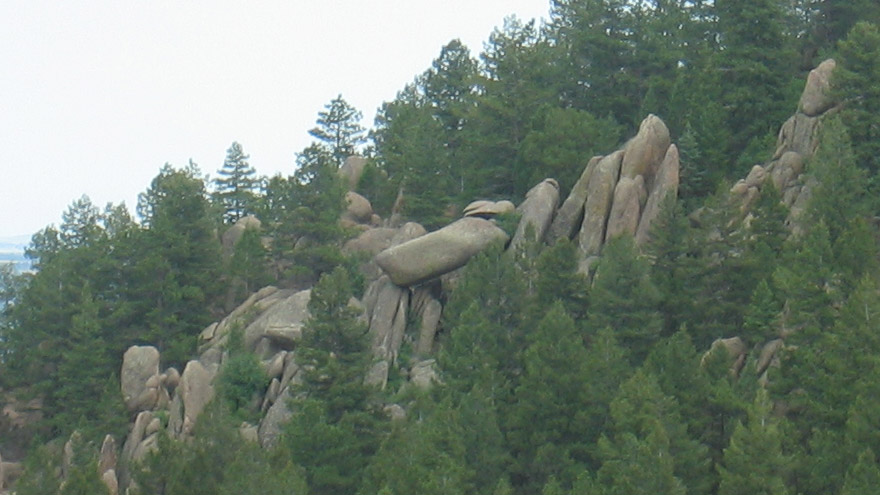
This cache is located near the start of Pike National Forest as you enter from the north.  The cache is an easy scramble down a little hill from trailside parking.  There are beautiful views of the valley to the east and as you look to the south east, you will see the balanced boulder shown in the photo above.  The cache container is a 50 caliber ammo can that was donated and camo painted by
fancifully handful.  She is in the USMC at Camp Pendleton working on the range where she gets all the brand new ammo cans she wants.

RM Off Road Series #1 Complete Cache Listing (North to South)

1. Balanced Boulder
2. Granite Overlook
3. Pikes View
4. Fallen Aspen
5. Valley View
6. Pikes Grand View

Trail Information

Rating/Description
This trail is rated easy but it is not your standard flat dirt road like Rampart Range Road.  It has lots of undulations, divots and off camber areas which makes it a fun route to drive.  Most stock SUV type vehicles should have no trouble on this trail.  Disclaimer: You need to decide for yourself if it is safe to make the trip in your vehicle.

Winter Months
The trail is closed to full sized vehicles from December 1st to April 1st.  During this time, it is open to small unlicensed vehicles.

Time/Distance
The entire trail is approximately 23 miles and should take about 3 to 4 hours driving time.  You will also need to include time for finding the caches, exploring, sight seeing, lunch, etc.

Trail Waypoints
See waypoint list below. (North to South Route)

Additional Waypoints

W1WEMH - Start of Dakan Road
N 39° 18.248 W 104° 58.122

W2WEMH - Bear Left at T and Then Stay Right When Road Forks
N 39° 18.545 W 105° 01.872

W3WEMH - Stay Left Where 503 Goes Right
N 39° 15.757 W 105° 03.473

W4WEMH - Turn Right on Rampart Road
N 39° 13.191 W 105° 03.712

W5WEMH - Start of Long Hollow Road 348
N 39° 13.159 W 105° 03.878

W6WEMH - Stay Left Where 650 Goes Right
N 39° 10.850 W 105° 04.683

W7WEMH - Stay Right Where 347 Joins on Left
N 39° 09.196 W 105° 05.138

W8WEMH - Turn Left to Highway 67
N 39° 08.040 W 105° 06.579

 Custom URLs

Add cache to watch list
Log your visit
Picture Gallery

 Additional Waypoints (8)

CodeNameTypeCommentsDateCoordinatesDistance
W1WEMHStart of Dakan Road Reference Point  06/05/2006 N 39° 18.248 W 104° 58.122 5.45 kms E 
W2WEMHBear Left at T and Then Stay Right When Road Forks Reference Point  06/05/2006 N 39° 18.545 W 105° 01.872 0.71 kms N 
W3WEMHStay Left Where 503 Goes Right Reference Point  06/05/2006 N 39° 15.757 W 105° 03.473 4.99 kms SW 
W4WEMHTurn Right on Rampart Road Reference Point  06/05/2006 N 39° 13.191 W 105° 03.712 9.57 kms S 
W5WEMHStart of Long Hollow Road 348 Reference Point  06/05/2006 N 39° 13.159 W 105° 03.878 9.70 kms S 
W6WEMHStay Left Where 650 Goes Right Reference Point  06/05/2006 N 39° 10.850 W 105° 04.683 14.13 kms S 
W7WEMHStay Right Where 347 Joins on Left Reference Point  06/05/2006 N 39° 09.196 W 105° 05.138 17.25 kms S 
W8WEMHTurn Left to Highway 67 Reference Point  06/05/2006 N 39° 08.040 W 105° 06.579 19.92 kms S 

 Nearby Caches

GCWEQF RM ORS #01-02: Granite Overlook (4.83 kms SW)
GCWEQQ RM ORS #01-03: Pikes View (8.43 kms S)
GCWER3 RM ORS #01-04: Fallen Aspen (10.00 kms S)
GC89383 How Low Can You Go (13.76 kms NE)
GCWER8 RM ORS #01-05: Valley View (16.90 kms S)


Driving Directions

 Logs

11 Logs: Found it 11  

Found it 10/20/2018 By kittredgekid
Great day for a hike with friends!

Found it 07/07/2018 By YamaGypsy
First cache of the day. Out with Lemonheadmafia and my son exploring the back roads. Cache is in good shape. Tftc!

Found it 06/26/2018 By bobbitandsnokums
TFTC

Found it 06/26/2018 By D_Brown
Good find!

Found it 09/15/2017 By trailblazing420
TFTC fun series

Found it 06/13/2017 By ranger98
Found this while riding the trails in our Commander.

Found it 09/05/2016 By Matt_Amanda
Love the area! Very nice cache!

Found it 08/10/2016 By Deadmoney
Out for a little jeeping, hiking, and geocaching with the girlfriend on a 23-mile drive through Pike National Forest. A little rain in the forecast, but who lets a little water ruin their day?? TFTC!! --Deadmoney

Found it 07/21/2016 By bobbyang67
Beautiful view

Found it 05/20/2016 By Geoweekend
Found it, beautiful views!

Found it 09/09/2015 By loverfishy
Sorry for the late logs- out jeeping and caching Colorado backroads with my #1 geo.buddy. Cool scenery here, and we found a few good camping places nearby to keep in mind for future trips. TFTC!