GC7JVKX Traditional Cache Dunraven Glade
Type: Traditional | Size: Regular Regular | Difficulty: 1.5 out of 5 | Terrain: 1.5 out of 5
By: Path Pacer @ | Hide Date: 02/26/2018 | Status: Available
Country: United States | State: Colorado
Coordinates: N40° 28.536 W105° 27.566 | Last updated: 08/30/2019 | Fav points: 0
Dogs  Recommended for kids  Takes less than an hour  Available at all times  Ticks  Parking available  Public restrooms nearby  Bicycles  Motorcycles  Horses  Park and Grab  Abandoned Structure 

Dunraven Glade used to be the main road to Glen Haven and as such was well-traveled.  The original route came overland from a point closer to Drake to the Gravel Pit, then up Dunraven Glade and down the North Fork of the Big Thompson River to the village.

Lord Dunraven maintained a hunting lodge here in 1877, purportedly on this very spot, for the use of his hotel guests. At one time, he entertained as many as 200 young Englishmen on a hunting expedition. It is rumored he buried barrels of whiskey near the lodge, but no one's ever been able to find them, including some Depression-era locals who dug up the place looking.

Fred Sprague used this road to transport his guests to the resort he built in 1908 farther up the valley at the site now called the Deserted Village. At the time it sported 11 cabins, a dining hall, an icehouse, a barn, and a dairy. After changing hands a few times, the site was eventually sold to the Forest Service in 1967, who razed the buildings. It is now within the Comanche Peak Wilderness Area, but you can still camp there.


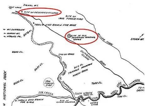
This cache is part of a geotrail of historical caches in the Glen Haven area. Retrieve the code from all 14 caches plus the found date of the virtual and receive a commemorative geocoin. The cache list can be found here: Historic Glen Haven GeoTrail. And remember not to be a cache pirate! If you take something, leave something at least as good for the next cacher.
 Custom URLs

Add cache to watch list
Log your visit
Picture Gallery

 Hints

Big rock.

 Nearby Caches

GC7JVWZ The Founders (2.55 kms S)
GC2PD4D NEVER OVERLOOKED (9.04 kms SE)
GCAHKRX Monday Morning Meetup 325 ? (37.10 kms E)
GC46P8K Quadruple Your Fizzy Fun! A Challenge (43.42 kms NE)
GC718JA What the Frack #33 (44.48 kms E)


Driving Directions

 Logs

10 Logs: Found it 10  

Found it 06/13/2019 By mmw83
Tftc! Went on a hike with lots of extended family. Enjoyed learning about some history of this place. Beautiful scenery abounds.

Found it 06/02/2019 By screechybird
Found after a 12-mile hike on the North Fork Trail. TFTC SL TNLN

Found it 05/28/2019 By apple nut
Nut found this one for ftf 2019. TFTC

Found it 10/27/2018 By jmuser
Nice one! Was out with the Mrs going for a leg stretcher up Bulwark Ridge and got this one while we were there. Very brisk wind blowing, but clear. Used this one and End of the Road for a warm up before heading up the ridge after The Clearing. TNLN-SL. TFTC!!

Found it 09/29/2018 By AJ3013
Beautiful drive! Great cache! Thank you!!

Found it 07/29/2018 By WingsAndTales
COpackrat showed me this one while we were in the area. I guess I have a new GeoTour to work on. TFTC

Found it 07/26/2018 By mesa finds
Thanks for the hide! Found this before our hike to the Pauldy Sawmill cache!

Found it 07/14/2018 By Gohappy7
Thanks happy

Found it 06/21/2018 By COpackrat
This wrapped it up for a fun afternoon. Thanks for the interesting caches and history - I'm learning a lot about the area!

Found it 05/29/2018 By Denali41
Since my early days of geocaching Crosier Mountain and its surroundings, including the Glen Haven, the Miller Fork, and Dunraven areas, have held special allure for me. The caches by Tahosa and Sons on Crosier and Round Mountains initially captivated my attention, eventually resulting in my development of the Celtic Cross Tribute cache on Crosier. And of course Crosier is so large that the complex contains four distinct ranked peaks, augmented by the adjacent Triangle Mountain, all of which I had hiked up. My attraction to the area had also been nicely enhanced by Path Pacer’s earlier cache placements in the area, and I eagerly sought out each after the publications of her caches. So when this GeoTrail series was created I became excited! I had previously found six of the 14 caches on the geotrail and enjoyed reading the cache descriptions for the more recently published eight, including this one. Cumulatively a great synopsis of the history of the area, indeed.

Well, most of the new caches were published while the Big Thompson Canyon Highway was closed for renovation. To reach Glen Haven from Wellington using the detour through Lyons takes an extra 1 ½ hours round trip. So I decided to wait on getting after the eight remaining caches until the highway reopened. It did, but I was in Cincinnati at the Giga Geowoodstock Event when that happened. Today was the first chance I had to make the drive up the improved Big T highway and on to Glen Haven; I was accompanied by my puppies Orizaba and Chimborazo. We had a fun time chasing down seven of the eight new caches, and thinking about the historical themes associated with each. I had expected to also get up Triangle Mountain for the final cache of the geotrail, but the weather was not looking promising; that final adventure is reserved for a future date.

Thanks for this cache and thanks for this entire geotrail series, Path Pacer! I took the trackable from the cache and will visit it around for awhile before placing it in another cache.