GC7F1Y2Between Two Rocks
Type: Traditional
| Size: Regular
| Difficulty:
| Terrain:
By: Path Pacer@
| Hide Date: 01/01/2018
| Status: Available
Country: United States
| State: Colorado Coordinates: N40° 27.882 W105° 27.104 | Last updated: 08/30/2019 | Fav points: 0
Park by the road, then head up the steep, faint trail on the other side. The mountain itself is an unofficial hike, but people climb it fairly regularly, so the trail is well-defined at first. It peters out about halfway up, but the bushwhacking is easy. It's a ranked peak, standing at 8415', and is the 147th highest in Larimer County. The trail is 1.4 miles long and climbs 1415'; the first half is quite steep. It took us 1.5 hrs to reach the top, where the views are fantastic!
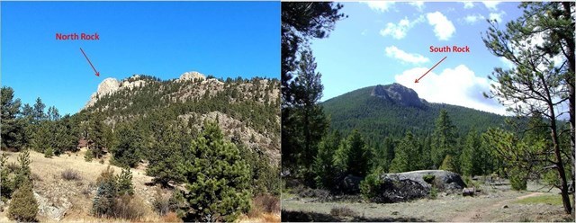
On the south side of Triangle Mt protrudes North Rock, so named because it is north of Glen Haven. If you look over to West Crosier, you will see South Rock, which is south of Glen Haven. When local resident Bob Easterday came to write his memoirs about growing up in this little community in the '20s and '30s, he called it "Between Two Rocks: True Tales of Early Glen Haven."
After the 2013 flood, Retreat residents had to hike over this mountain to reach their homes, as CR 43 had been completely obliterated. At first they went directly up and over to Solitude Ct, but quickly realized it was easier to hike along the south side to the Dunraven trailhead parking lot. The resulting beaten path was called Tortoise Trail and made for a nice little hike, but it's all but gone now.
If you're interested in reading Bob's book, or others about the early history of this area, contact the Glen Haven Historical Society. (They have a facebook page.)
The GHHS was started in 2003 by Duke Sumonia, and it was his research that furnished me with the information to place several historical caches in the area. Sadly, he passed away in 2015, after living many years at the foot of this mountain. This cache is dedicated to him.
This cache is part of a geotrail of historical caches in the Glen Haven area. Retrieve the code from all 14 caches plus the found date of the virtual and receive a commemorative geocoin. The cache list can be found here: Historic Glen Haven GeoTrail. And remember not to be a cache pirate! If you take something, leave something at least as good for the next cacher.
06/23/2018 By COpackrat Fun hike - After visiting with the CO at the Coffee by the Park event, I headed off for my final stop on the GlenHaven GeoTour. It was quite cloudy, and had rained the night before, so I was happy to get to the summit before the weather further deteriorated. Soon after I reached the summit it started to graupel, and then turned into rain. The views from the top were of the main peaks covered in clouds and the visibility was not as far as I would have liked, but I was well on my way back to the trail head before I heard the first thunder. Nice finish to a great experience learning about the area's history and visiting interesting sights. Thanks for all the effort you put into providing us with such a nice tour!
06/02/2018 By Denali41 In March, 2007 Denali Queen (Carolyn Randall), my puppy Teewinot, and I hiked to the summit of Triangle Mountain. It was a very memorable hike that occurred just after a major snowstorm. Triangle was buried in snow. We started in Glen Haven. Carolyn had a CMC friend who had a home just across the bridge north of the General Store. He let us park in his drive and cross the North Fork on his footbridge. We made our way up the mountain with a decent pace considering the snow. When we were more than halfway to the summit we came across the partially eaten carcass of a mule deer. The story was clearly displayed in the snow. A mountain lion had killed the deer, eaten a portion of it, and had buried the remainder in the snow. We continued to the summit, enjoyed the views, and “checked off” another mountain in our quest to become the first people to summit all 256 ranked peaks in Larimer County. We descended and when we neared where the deer carcass had been partially buried Teewinot went nuts and sprinted toward the spot. The lion had returned to munch some more. This was Tee’s third encounter with mountain lions and she acted as she always did–she barked like hell and ran after the lion. The cat took off and was much faster than Tee in the deep snow. Teewinot finally bogged down and made her way back to us.
I was thinking about that encounter today as I made my way up the trail from the designated parking coordinates. Today my puppies Orizaba and Chimborazo were with me. Neither has experience with mountain lions, and I hoped we would not encounter a lion today. We didn’t. We had a marvelous hike to the summit, where I found the summit register and wrote a memorial piece to my past climbing and backcountry geocaching partner, Denali Queen. From the top we dropped down a short way and made a quick find of this cache–the last of the 15 I needed in order to complete the geotrail. We sat in the shade of a nearby tree where I ate my lunch and the dogs had some dog biscuits. We stayed for perhaps 30 minutes, admiring views of so many peaks I’ve climbed at least once and, for some, many times. I thought about this superb geotrail. Some of the caches associated with it, such as Pauldy Sawmill, Piper Ranch, Anderson House, and Cliff Cleft Cabin, I had found many years ago. Each had interesting history lessons associated with the cache descriptions. And the newer ones, placed to complete this marvelous series, zipped together so much more of the history of this area. Path Pacer has created a fine historical synopsis, integrated through the 14 caches she has set out for the geotrail to become a reality. Yes, I thought about each of them as I sat below the summit of Triangle Mountain, and Zaba and Chimi were calm as they silently supported my reflections on this fascinating grouping of geocaches. Thanks so much for them, Path Pacer! I will write you soon with the codes I’ve collected!
CONTINUED But I’m not finished. I began this Found it log summarizing that memorable hike in the snow with Carolyn and Teewinot. Carolyn, Denali Queen, was my long-term climbing partner and geocaching companion. We climbed hundreds of mountains together in Colorado, North America, and the world. A year after our mountain lion encounter on Triangle Mountain we went with some mountaineering friends to climb some peaks in the European Alps. Mont Blanc was first, and the Matterhorn was the second mountain on the agenda. We had a tremendous climb on Mont Blanc and then traveled by train from Chamonix to Zermatt. Disaster struck on the Matterhorn, where Carolyn and one other friend were killed during an extreme lightning storm while descending from the summit. This year marks the 10th anniversary of their tragic deaths. I will hike up that day to Chasm View on Longs Peak, where her ashes were scattered by the winds.
Denali Queen was treasured by geocachers who met her at Events or had the good fortune to hike and climb with her to find caches in mountain environments. Four backcountry caches have been placed in her memory, and each is highly deserving of the serious effort required to reach and find it. These four memorial caches are: Carolyn’s Cache (GCHAAF), a 5 X 5-star cache owned by Tahosa and Sons in Colorado; The Mull of Crosier (GC1TE2C), a 2.5 X 4.5 beauty hidden on Crosier Mountain by Team Laxson; Truly A Friend (GC1WQK9), a superb 2.5 X 2.5 caching sequence placed by Tahosa and Sons in the San Tan Mountains of Arizona on the first anniversary of Denali Queen’s death (unfortunately since archived when Tahosa’s family moved back to Colorado); and Denali Queen (GC32YPY), a 2 X 4.5 cache placed by me on the third anniversary of her death as I descended from a technical climb of Washakie Needles, a peak that ranked near the very top of Carolyn’s list of most wanted climbs. That cache is in Wyoming. I encourage those interested in learning more about this great backcountry geocacher and climber to read the cache descriptions for these four caches, and consider going after the three that are still active. So that's some "history" that follows on my opening comments about this cache on Triangle Mountain. CAROLYN WOULD HAVE LOVED THE CACHES ASSOCIATED WITH THIS GEOTRAIL!
01/06/2018 By GotYour6 ### FTF!!! Saturday 1-7-18 at 1:02 pm. Heck of a climb!!! Great FTF prize! We took the TB coin, left a TB and a hot wheels type car. Thanks for the great cache. ### {FTF}
 Between Two Rocks
 | Difficulty:
  | Terrain:


")