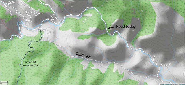
The first road up the Big Thompson from Loveland to Estes Park didn't follow the track it does today. From Drake, it went up the North Fork to the posted coordinates, then cut overland on Glade Road to the Gravel Pit trailhead. The road didn't continue along the river until around 1910, at which time the overland route was largely abandoned because it was too steep for horses. Today it is privately owned.
During the 2013 flood, most of CR 43 was completely destroyed. Road crews used Glade Road to get heavy equipment to the gravel pit, greatly speeding the reconstruction process.
As an aside, the house by the coordinates used to have a sign in front that read "Cows Not Mine." Apparently the cows in the nearby field would excape and the homeowner got tired of people stopping to tell him. When the house was sold just before the flood, the new owners took down the sign, but you can still see it in the upper window of the barn. The Cows Not Mine House is often referenced as a local landmark.
 This cache is part of a geotrail of historical caches in the Glen Haven area. Retrieve the code from all 15 caches and receive a commemorative geocoin. The cache list can be found here: Historic Glen Haven GeoTrail. And remember not to be a cache pirate! If you take something, leave something at least as good for the next cacher.
Additional Waypoints
 Glade Road
 | Difficulty:
  | Terrain:


