 This is GeoTom. He loves hiking on Arthur's Rock and wants you to learn a little about this place. GeoTom has taken his human along on this hike a few times and has decided that he should create an Earthcache to help people slow down and observe where they are.
GeoTom appreciates that this location is open to his fellow four legged friends and that the fee for his human to park is nominal and included when he purchases a vehicle pass. GeoTom also appreciates it when his human and all of his human friends follow all of the rules and regulations of the park. GeoTom laughs at his human when he stops by the Ranger station at the entrance and picks up a map but knows they are available so he forgives him.
GeoTom loves photos and hopes you will post many from your adventure.
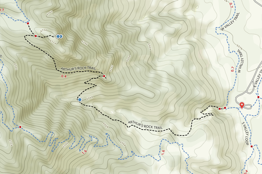
 Arthur's Rock is a formation of pegmatite granite that bulges out of the rolling foothills on Colorado's Front Range. Located in Lory State Park, Arthur's Rock is one of the more popular hikes near Fort Collins. It starts at an elevation of about 5,500 feet and rises to an elevation of 6,782 feet. During the ascent, you will find yourself walking through dense Ponderosa Pine forest. In a turn of a corner, grassy meadows will appear and beautiful flora will follow. During the spring and throughout the fall Lory State Park is glittered with wildflowers. A large mass of steep, solid granite will appear without warning and may look like a daunting conundrum. A semi-steep rock gully takes you to the summit. However, it never gets harder than an easy class 2.
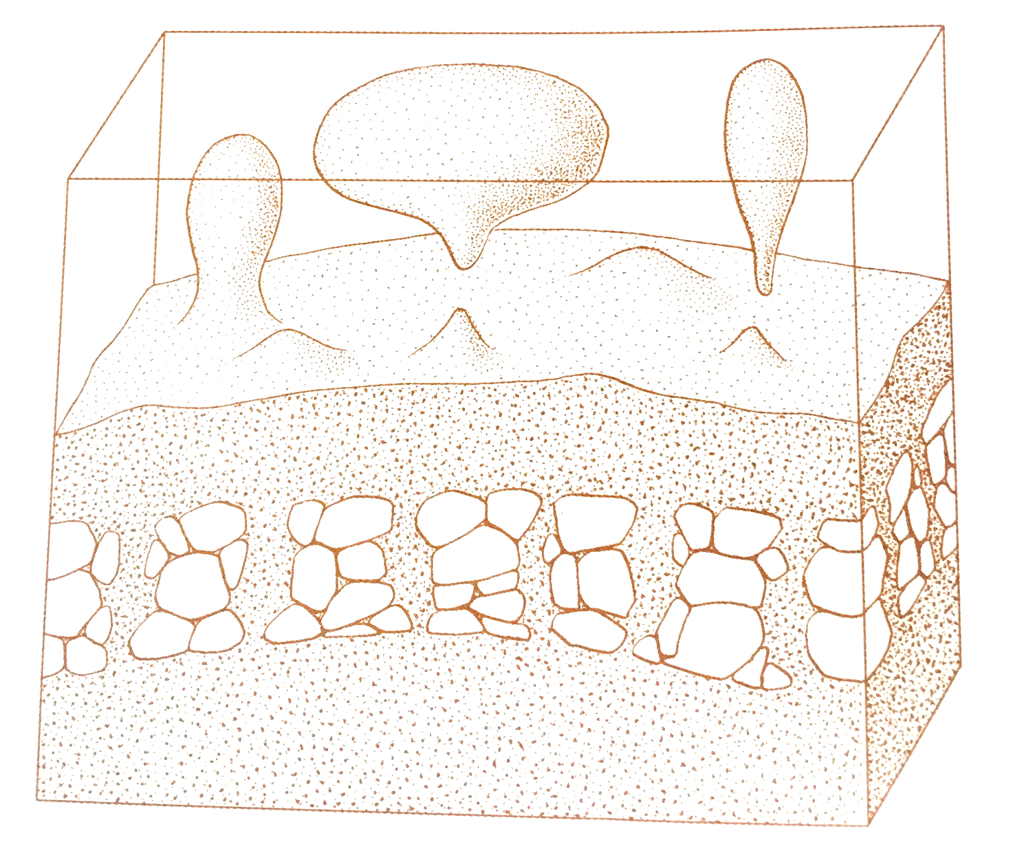 According to Geology.com, Pegmatites are extreme igneous rocks that form during the final stage of a magma’s crystallization. Put simply, light molten blobs of granite rise from rocks melted deep in the earth's crust. Large blobs called plutons coalesce and cool as batholiths, which are immense rock masses in the core of mountain ranges.
In geological terms, they are extreme because they contain exceptionally large crystals and they sometimes contain minerals that are rarely found in other types of rocks. To be called a “pegmatite,” a rock should be composed almost entirely of crystals that are at least one centimeter in diameter. The name “pegmatite” has nothing to do with the mineral composition of the rock. Most pegmatites have a composition that is similar to granite with abundant quartz, feldspar and mica. These are sometimes called “granite pegmatites” to indicate their mineralogical composition. However, compositions such as “gabbro pegmatite,” “syenite pegmatite” and any other plutonic rock name combined with “pegmatite” are possible.
Quartz-bearing pegmatites are often associated with masses of granite and may be seen in many places in New England, Colorado, and Canada. Whitish quartz crystals to 6.5 feet long by 1.5 feet in diameter have come from pegmatites in New Hampshire. A single crystal 8 feet long and 6 feet in diameter was on exhibit in Tucson, Arizona, a few years ago. It was from a pegmatite in Africa and was the typical milky color.
There is a common misconception by both hobbyists and miners, that somehow the present topography had an influence over the deposition of quartz veins. Actually, the presence of quartz veins, as a cementing agent in sandstones and as a highly erosion-resistant unit when present as thick veins, exerts an influence over how the topography develops.
Authigenic crystals form after the deposition of the original sediment, and either before, during, or after the processes of compaction and lithification. Silica is dissolved and then reprecipitated, crystallizing as quartz during this process.
TO LOG THIS CACHE:
You must answer these questions and e-mail me your answers. Do NOT post answers in your log (even if encrypted) or it will be deleted. Logs without verification will also be deleted. Photos are not required, but are encouraged (without spoilers).
Logging requirements
Send me a note with :
- The text "GC5F195 Arthur's Rock" on the first line
- The number of people in your group.
- Identify the the other type of mineral, besides granite, that is prominent in this formation.
- What is the largest size of the other mineral you can find at GZ? You can provide a measurement or approximate size.
- What do you believe is the cause of the quartz being so prominent in this formation?
The above information was compiled from the following sources:
- David Lambert and The Diagram Group, The Field Guide to Geology new edition, Checkmark Books, New York, NY
- Colorado All Trails http://alltrails.com/trail/us/colorado/arthurs-rock#
- Geology.com http://geology.com/rocks/pegmatite.shtml
- Rouckhounding Arkansas http://www.rockhoundingar.com/mineralogy.php
- Colorado Parks & Wildlife site http://cpw.state.co.us/placestogo/parks/Lory
- On site literature and signs
Map Link
GeoTom knows how worried humans are so he wants to provide a little more information before you get started.
Park Office
708 Lodgepole Drive
Bellvue, CO, 80512
Park Hours
5:00am - 7:00pm
Office Hours
8:30am - 4:00pm Mon-Sun
Phone (970) 493-1623
Fax (970) 493-4104
Email: Lory.park@State.co.us
Special note: Depending on the time of year and length of the day the park will close sooner or later. The park can close as soon as 6 PM during the winter and 9 PM in the summer along with 7 and 8. Check times before you play your trip.
Additional Waypoints
PK5F195 - Parking Lot
N 40° 33.860 W 105° 10.450
If this parking lot is full there are additional lots available.
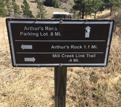
TH5F195 - Arthur's Rock Traihead
N 40° 33.860 W 105° 10.492
Trailhead is clearly marked.
 Hiking with GeoTom #7
 | Difficulty:
  | Terrain:


")


