GC3675Z Traditional Cache Pauldy Sawmill
Type: Traditional | Size: Regular Regular | Difficulty: 1.5 out of 5 | Terrain: 4 out of 5
By: Path Pacer @ | Hide Date: 10/18/2011 | Status: Available
Country: United States | State: Colorado
Coordinates: N40° 30.456 W105° 28.607 | Last updated: 08/30/2019 | Fav points: 0
Dogs  Significant hike  Available at all times  Not Available during winter  Ticks  Not Wheelchair accessible  Parking available  Public restrooms nearby  Bicycles  No Motorcycles  No Quads  No Horses  No Park and Grab  Abandoned Structure  Medium hike (1km-10km) 

Start from the Dunraven Trailhead. The Indian Trail is a steep trail up over Bulwark Ridge to Miller Fork, where it becomes gentler as it follows the trail upstream. There are a couple of other geocaches along the way.
The meadow contains the remnants of the T.M.Nagle boiler and engine from the Pauldy Sawmill on Miller Fork. It belonged to George Pauldy and was destroyed in a 1905 forest fire that was thought to have been started two weeks earlier by careless campers. Firefighters struggled to save it and thought they had succeeded, so they moved on to protect Danner's sawmill farther up the mountain (Donner Pass is probably misnamed), but the fire shifted and poor old George lost his mill anyway, along with 40,000 board-feet of lumber worth $2,000. If you continue a quarter mile up the trail past the sawmill, you'll find the remnants of a cabin.

Please don't remove anything from the site. Leave the artifacts as you found them for others to enjoy!


Boiler and Steam Engine


What they once looked like


This cache is part of a geotrail of historical caches in the Glen Haven area. Retrieve the code from all 14 caches plus the found date of the virtual and receive a commemorative geocoin. The cache list can be found here: Historic Glen Haven GeoTrail. And remember not to be a cache pirate! If you take something, leave something at least as good for the next cacher.

Additional Waypoints

013675Z - Trailhead
N 40° 28.544 W 105° 27.638

 Custom URLs

Add cache to watch list
Log your visit
Picture Gallery

 Additional Waypoints (1)

CodeNameTypeCommentsDateCoordinatesDistance
013675ZTrailhead Trailhead  03/03/2018 N 40° 28.544 W 105° 27.638 3.80 kms S 

 Hints

Big rock.

 Nearby Caches

GC5F195 Hiking with GeoTom #7 (25.36 kms E)
GC9H2EW Monday Morning Meetup 203 (35.76 kms E)
GC5F2BB John Glenn (44.23 kms E)
GC5F2HM Find the Log to Log the Log (50.13 kms E)
GC16RX9 -TwoCs- Happy Hour (51.16 kms SE)


Driving Directions

 Logs

5 Logs: Found it 4  Owner Maintenance 1  

Found it 07/26/2018 By mesa finds
What an awesome hike!! Took the wife and dog and covered the almost 8 mile round trip. Never knew these trails existed even though we have been coming to Glenhaven for many years...definitely a favorite point here!

Found it 06/22/2018 By COpackrat
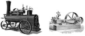
That was certainly an interesting hike. I didn't look closely at the elevation changes before setting out, and it was quite a drop to (and climb back out of) Miller Fork! But what a nice area - lots of water in the creek and the waterfalls were really pouring. The trail was lined with lots of columbine and wild geraniums, and the sections through the thick pines was a nice break from the meadows. Interesting equipment still remaining at the mill site, and it all made for a great walk. Thank you for bringing me to this nice spot!

Owner Maintenance 06/19/2017 By Path Pacer
I hiked up this morning to show a friend the sawmill and checked on the cache while I was there. Added a little swag (remember to leave something if you take something). It's in good shape.

Found it 04/11/2015 By wayne0351
What a cool little spot to check out! I love old machinery like this. Sat on a the boiler and had a peanut butter and jelly sandwich.... After I found the cache of course. Never would have found this if it wasn't for your cache. Thank you

Found it 10/23/2014 By The Gope
N40° 30.460 W105° 28.606
Lovely fall hike up one of my favorite trails. Lots of obvious trail repair work since the flood. Thanks to whoever did it. Took a magnetic horse head to leave some where else.

Added coordinates from my Garmin 910. So very close it is with in the error. Altitude recorded was 8340.