The reason for this EarthCache
To celebrate our 20th wedding anniversary, the CFO of the Memfis Mafia and I (Memfis) decided to do a couple of the things we enjoy doing as a family - hiking and geocaching. Since there wasn't already a geocache in the area, we thought we would create one for others to enjoy.

The Geology
In this earthcache you will learn about geologic unconformities.
At the coordinates you will find a geologic unconformity.
An unconformity is a gap in the sequencing of the layers of rock. Layers of sedimentary rock are laid down flat, parallel to the earth's surface. This is the law of original horizontality. Younger or new layers always overlie the older layers. This is the law of superposition. An unconformity exists when this orderly stacking of layers of rock is interrupted or broken.
There are four kinds of unconformities:
1. Angular unconformity
2. Nonconformity
3. Disconformity
4. Paraconformity
An angular unconformity occurs when the rocks on the top are level and the rocks below are tilted. This was the type of unconformity that was originally discovered in the 1780's by James Hutton in Scotland. He noticed the unconformity and recognized that significance of the amount of time that must have passed for the formation of the unconformity. An angular unconformity occurs when the oldest rocks are laid down, and then these rocks are tilted and eroded flat, and the next set of newer rocks are laid down on top of the flatened, but tilted rocks. See the drawing.

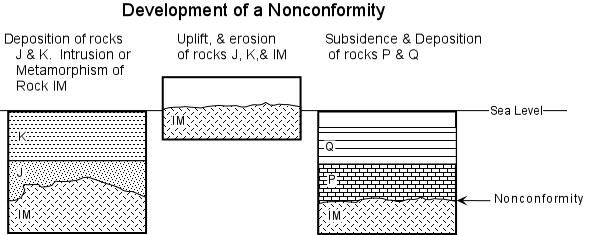
A nonconformity occurs when sedimentary rocks are laid down on top of a non-sedimentary rock, like a lava flow or other type of igneous rock, e.g. granite or gneiss.
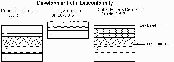
A disconformity occurs when there is a gap in the succession of the rock layers. The older rocks are laid down, but because of erosion, some of the normally-expected subsequent layers of rock are missing. Then newer layers of rock are formed on top of the older rocks. The result is a sequencing of parallel rock layers that do not contain all of the expected layers.
A paraconformity is a discontinuity that is not visible. These may be difficult to observe and may discernable only from other investigations. An example of a paraconformity would be a unexpected gap in the normal layer of fossils contained in the rocks.
The Questions
To log this earth cache you must do the following:
Stage 1: What type of unconformity do you see at 163 degrees South.
Stage 2: At 90 degrees East, you should see another unconformity. What type is it and what do you think caused the vertical markings?
Stage 3: Look 288 degrees West, what type of unconformity do you see?
Stage 4: Look SouthWest, you now have a different view of the previous stage. Do you see different colors in the rows? Describe the colors.
Final Stage: Walk the short distance from Stage 4 to the waterfall. What is the elevation?
Additional Waypoints
017W14T - Trailhead
N 39° 39.049 W 106° 19.271
At the trailhead you will find a sign with information and warnings about wildlife.
027W14T - Stop 1
N 39° 39.146 W 106° 19.212
Stop 1 - You will be looking for a geologic feature to the south of your location. (163 degrees S)
037W14T - Stop 2
N 39° 39.263 W 106° 19.159
Stop 2 - look for the prominent geological feature directly to the east of this point (90 degrees E)
047W14T - Stop 3
N 39° 39.574 W 106° 18.815
Stop 3 - Look for the prominent geological feature to your west (288 degrees W)
057W14T - Stop 4
N 39° 39.806 W 106° 18.695
Stop 4 - Look SW, you now have a different view of the previous geological feature.
067W14T - Waterfall
N/S __ ° __ . ___ W/E ___ ° __ . ___
Final Stop - This is not far from stop 4. You will need to determine the elevation from the waterfall's edge.
 Anniversary EarthCache
 | Difficulty:
  | Terrain:


")