|
GC8WNZ3
 Cache of the Ancient Mariner
Type: Mystery | Size: Other  | Difficulty:
  | Terrain:
  By: K Trackers @ | Hide Date: 07/04/2020 | Status: Available Country: United States | State: Colorado Coordinates: N38° 57.635 W104° 43.269 | Last updated: 06/19/2022 | Fav points: 0 


")

The Rhyme of the Ancient Mariner (ROTAM) is the longest major poem by the English poet Samuel Taylor Coleridge (1772 - 1834), written in 1797–98 and published in the first edition of Lyrical Ballads, 1798. ROTAM immediately captured the public’s imagination and was unique due to its intentionally archaic language (originally titled The Rime of the Ancyent Marinere), length, moral narrative, major theme of destroying nature, strange scholarly notes printed in small type in the margins, and thematic ambiguity. Along with other poems in Lyrical Ballads, ROTAM represented a shift to modern poetry and marked the beginning of British Romantic literature. In 1800, ROTAM was rereleased with the archaic words eliminated. Historians suspect that ROTAM was inspired by James Cook's second voyage of exploration (1772–1775) in the South Seas and Pacific Ocean. Coleridge's tutor, William Wales, was the astronomer on Cook's flagship and had a strong relationship with Cook. ROTAM’s impact on Western Culture is largely forgotten while the poem slowly fades to obscurity in popular literature. In modern times, reading of the poem is often restricted to serious literary students, literary analysis curriculum, and certain artistic venues that keep contemporary society connected to it. For example, there is a 1984 music version by the group Iron Maiden, the 2006 BBC reading by Ian McKellen, and a 2020 University of Plymouth version called The Voyage Complete: The Rime of The Ancient Mariner with readings by celebrities paired with artwork from contemporary artists.
Cache Summary Five years in the making, this cache is a reboot of the original GC35920 Cache of the Ancient Mariner; archived in 2015. The new version requires visiting five waypoints to determine the location of the final container. Each waypoint includes a task requiring use of navigation, sailing and other nautical knowledge employed by 18th century mariners. Nautical terms in the cache description are hyperlinked to allow geocachers to be clear on the precise meaning of terminology. Please note the listed attributes. BYOP. An average geocacher that can follow directions, is willinging to do a little extra reading, and has the right special tools should be able to complete this cache in approximately 30 – 90 minutes. In addition to special tools, something to record answers to compile the final coordinates is needed. While the lengthy cache description may seem daunting, the waypoints are relatively straight forward and tend to go quickly in the field. Waypoints can be done in any order, except that Waypoint 5 is recommended to be done last. I hate to have to remind some geocachers; but please don't cheat, break open containers or try to bypass puzzles, ask for or hand out solutions / coordinates / TB codes, etc. Please take care of the customized containers and props. Honest mistakes can happen, so please notify the CO immediately if you find or accidently cause a problem. Thanks in advance for your cooperation. The final container can be found at: N38° 5A.BCD W104° 4E.FGH
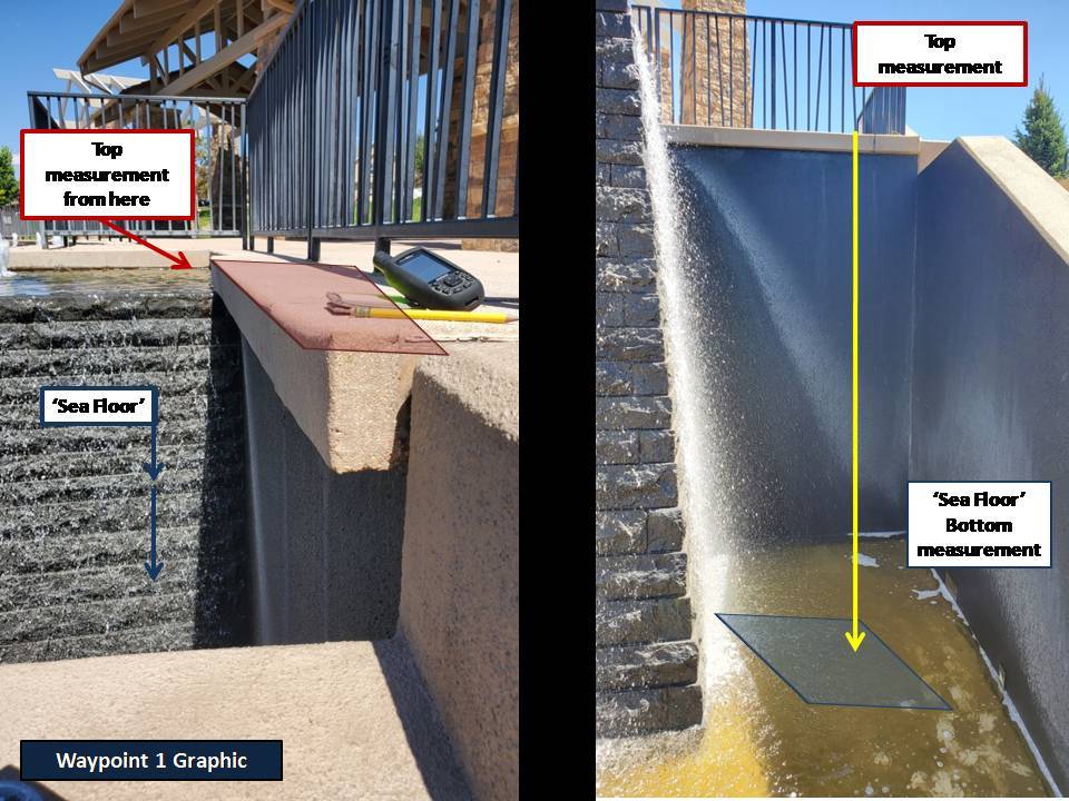
Waypoints Waypoint 1: Sounding. Sail to the posted coordinates for convenient parking. Once there, determine the depth from the noted, concrete top edge to the concrete bottom of the 'sea floor' below you. See the Waypoint 1 Graphic for a visual description. Record your answer in fathoms (using US fathom measurement), rounding to the nearest whole number. The correct answer is a one digit number that will provide your “E” number to the final coordinates.
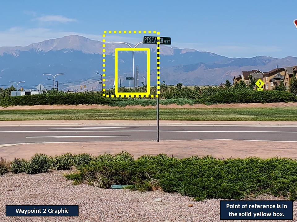
Waypoint 2: Bearing. From the posted coordinates navigate to the Waypoint 2 coordinates. At these coordinates you will find a narrow “deck” and a metal “mast.” Facing approximately South West, shoot a bearing to the nearest metal “mast” that looks exactly like the one that you are standing at. See the Waypoint 2 Graphic for a visual reference of your bearing target. Make sure you take your bearing from the single “mast,” not from the split arms of the “Y.” The correct answer is a three digit number that will provide your “B” and “G” numbers to the final coordinates. The last number of your three digit answer is your “B” number. The “G” number is obtained by subtracting the first digit from the second digit of your three digit bearing. This three digit number is also the combination to the container at Waypoint 5.
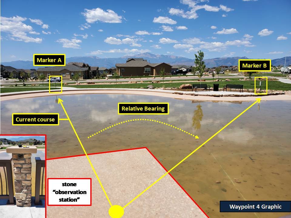
Tip: For the most accurate measurement, make sure your feet are planted and the “mast” is centered and touching your back. Waypoint 3: Futtocks. Navigate to the Waypoint 3 coordinates where you will find a structure. Go into the center of the structure and look up. Count the objects that most closely resemble futtocks. The correct answer is a one digit number that will provide your “H” number to the final coordinates. Waypoint 4: Relative Bearing. Navigate to the waypoint coordinates, there is convenient parking nearby. At the coordinates you will be on a “deck” with a stone “observation station” to your front, see the Waypoint 4 Graphic. Your ship is currently charting a course to “marker A,” a small metal sign approximately chest high. Plot the relative bearing to “marker B,” a similar sign of the same height. The correct answer is a two digit number that will provide your “A” and “D” numbers to the final coordinates. The first digit providers your “D” number. The second digit provides your “A” number.
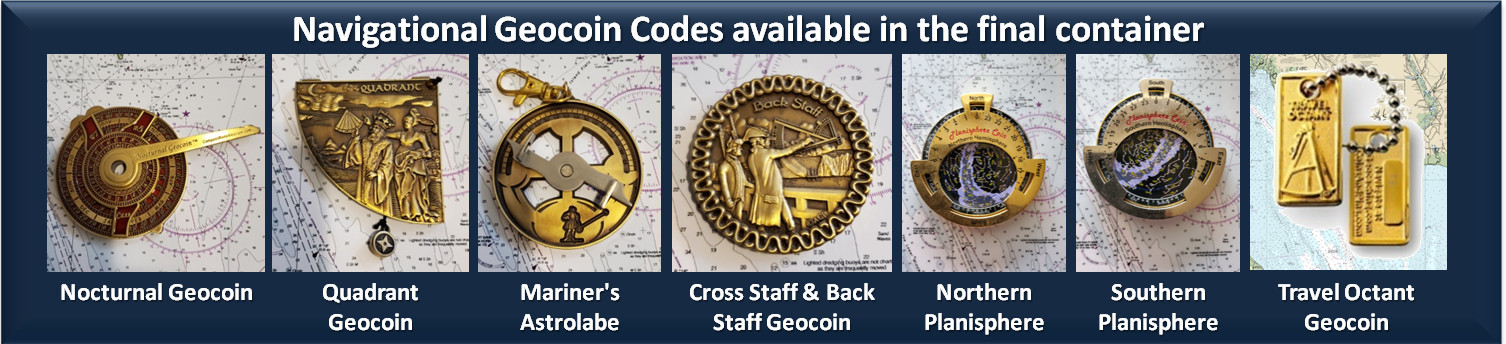
Tip: For a more accurate reading use the stone “observation station” to brace your body and arms. When shifting from marker A to marker B, keep your feet planted at the base of the “observation station” and only turn your upper body. Getting the same reading twice in a row may indicate you are getting an accurate reading. If you are having problems getting an accurate reading, try taking multiple readings with the same body position and generate an average. If at the end you still can’t pass the checker, go back and check your work on other waypoints as they are easier to verify. Once you have full confidence in those results, you can come back to this waypoint and keep working solutions. Waypoint 5: Charting a Course. It is recommended to do this waypoint last. Navigate to the Waypoint 5 coordinates, there is convenient parking nearby. At the coordinates you will find a labeled and locked large sized container. The combination to open the container is the three digit bearing number you recorded at Waypoint 2. This waypoint will require you to read, interpret and record data from a Nautical Chart. Specifically, you must exercise basic chart reading and measurement skills to complete the waypoint. Detailed instructions, additional reference material, and all items you need to complete this waypoint are located inside the container. After unlocking and opening the container, read the instructions and conduct an inventory of the contents to make sure nothing is missing or damaged. Everything in the container is tied down to prevent theft, so please handle the equipment carefully. Note there are some handwritten updates in blue sharpie pen. Also, please exercise care in repacking and relocking the container as the contents are expensive and difficult to replace. Tip: Completing the waypoint entails some time spent sitting and bending over the chart. While there is a small, vinyl "seat" under the container for your use; bringing a small seat, sitting pad or blanket may make you more comfortable. Tip: Language used on the instruction sheet is precise. Make sure you are reading carefully so that you don't generate a wrong number or fail to find a reference point. Final Container: Once all waypoints have been completed, you should have the final coordinates and enough nautical skill to find the final cache container. The cache has a geochecker and you should be able to access cellular data at every waypoint. Finding the final container will reward you with completion of a cache that was hopefully fun, armed you with some practical knowledge, and added a earned and nice D/T rating to your profile. If you check in the final container’s cargo hold, you additionally be rewarded with tracking codes to functional navigation geocoins from the Ancient K Tracker’s personal collection. Each coin not only has a short write up if you want to know more about 18th century nautical navigation, but also adds a unique geocoin icon to your profile.
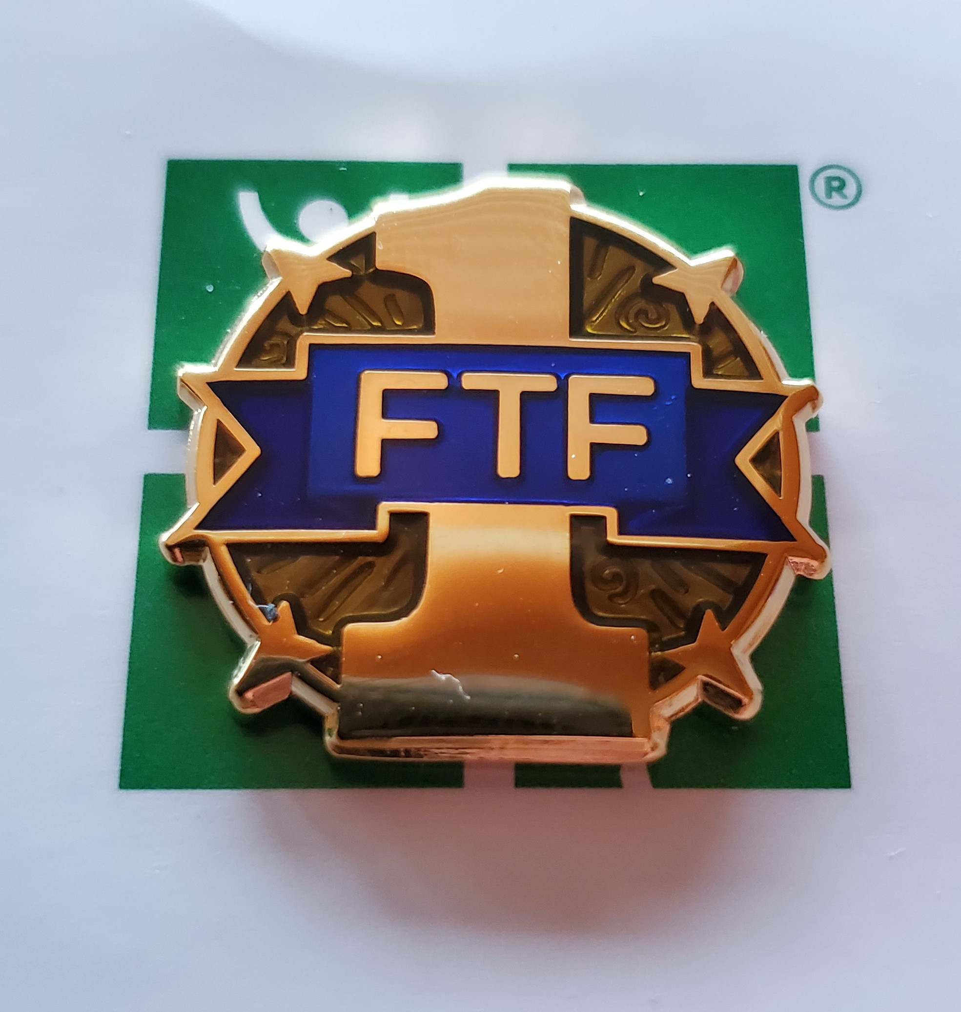
There is also an unactivated FTF micro geocoin as a prize to the first geocacher who can successfully navigate to the final container.
Special thanks to PatriotFan97 for helping with land management issues and getting the cache published. Congratulations to titocache for FTF on the orginal GC35920 Cache of the Ancient Mariner. Congratulations to PatriotFan97 for FTF. Do your best so the crew doesn’t hang a DNF around your neck. Good luck and I hope you have fun.
Additional Waypoints 018WNZ3 - SoundingN 38° 57.628 W 104° 43.304 028WNZ3 - Bearing N 38° 57.589 W 104° 43.304 038WNZ3 - Futtocks N 38° 57.659 W 104° 43.486 048WNZ3 - Relative Bearing N 38° 58.247 W 104° 43.396 058WNZ3 - Charting a Course N 38° 57.568 W 104° 42.774
Add cache to watch list Log your visit Picture Gallery
Final: No special tools are needed at the final, only a GPS and writing utensil. Final: Keep your feet off man made material, and on natural material.
GC4FGMQ GERR (4.49 kms S) GC7V0K8 IASD #17 (5.87 kms W) GC6MX6X The Tango (9.92 kms SW) GC6MWW7 The Foxtrot (10.22 kms SW) GC9WVMP The Places That Shape Us #5 (10.24 kms SW) |
Driving Directions
2 Logs:
|