As early as the 1860s, Scandinavian loggers lived in the Elk Creek area where Staunton State Park is now located. The Mason Creek Trail, Old Mill Trail and Border Line Trails converge at the site of an old collapsed sawmill and associated bunkhouse which became part of the Staunton Ranch.
Logging and lumber production were important Colorado industries in the late1800s and early 1900s. Timber was readily available and needed for railroads, mines, buildings and heating. Before the invention of sawmills, boards were made by hand sawing and manual planing. By the early 1900s the Staunton Ranch area had several sawmills: facilities where logs were fed into circular saws and cut into planks. Most of these were known as portable mills, where the equipment could be relocated closer to the active tree felling operations, and no permanent structures were involved. Evidence of four portable mill sites can still be seen within the Park, with piles of cut tree remaining today.
The Elk Creek area included at least three sawmills. The one at which this geocache is found is at Black Mountain Creek and was built between 1918 and 1934, but an earlier mill owned by Jesse Ray was already operating in the early 1900s. The photo of that mill illustrates the type of operation that could be achieved at that time. Typical transportation of logs is shown in the next photo, from a logging operation near Shaffer’s Crossing about 1910.


Archibald Staunton acquired the land with the Black Mountain Creek mill in the 1930s and built a bunkhouse to house six workers. At the geocache location you will see ruins of the sawmill itself plus the bunkhouse, an outhouse, and the remains of an old Pierce Arrow car. We know that such a car was owned by the Stauntons, and it is likely that the engine was used to power the cutting equipment at this sawmill, which could generate more torque than the standard steam-powered engines commonly used in sawmills about 1900.
Imagine trying to drive this truck up to this remote spot!
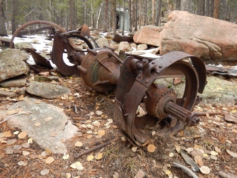
At least six workers were employed in the sawmill during the summer months. The evidence of several old roads can be found in the immediate area which indicate that logs were moved from several nearby locations to the mill for processing. Also, there was a skyline cable across the canyon above the sawmill, which was used to ferry logs from higher elevations which were not accessible by road. This cable system was powered by a Studebaker truck engine. Access to the skyline cable area is quite difficult, and access is discouraged at this time to protect sensitive resources in the area.
Imagine workers living in this area 100 years ago, cutting down huge trees by hand, next cutting off the tree limbs, then using cables, horses or mules, and manpower to haul massive logs to this sawmill, and finally taking finished planks down the mountain for use in local cabins, other buildings, mines and railroads.
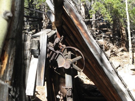
In 1942 the Stauntons donated much of the metal from the sawmill for a World War II scrap metal drive, and logging operations at the ranch ended. The sawmill collapsed in the early 1970s, but the bunkhouse (pictured about 1930) continued to be used by ranch guests until 1989 when Frances Staunton donated the ranch to the State of Colorado.

The most direct route to this geocache is from the Lazy V parking area along the steep Old Mill Trail (hikers only), but it can also be reached by way of the Mason Creek and Border Line Trails (which allow cyclists and equestrians). Please avoid disturbing any buildings and artifacts at the mill site, and respect all area closures. For your safety, do not venture inside the fences. Note: The geocache container is not located inside any buildings or ruins and will not require you to move any artifacts.

This cache is located within Staunton State Park, which has one public entrance along S. Elk Creek Road, six miles west of Conifer, about 1.5 miles off U.S. Highway 285. Parking along either side of S. Elk Creek Road and Upper Ranch Road adjacent to the park boundary is prohibited. All vehicles entering the park must have a daily park pass ($10) or a CO state park annual or special pass.
The Park is open year-round, and day use hours are 6:00 am to 10:00 pm. A walk-in campground (up to Ľ mile from parking) is open for public use, and overnight parking is currently permitted only for those staying in the campground. During summer and autumn weekends, the park may reach capacity, and cars are allowed to enter only if a parking space is available. Horse trailers are admitted if space is available for parking trailers. All Park trails are natural surface, some trails are hiker-only, but other trails are multiuse for bicycles and horses also. Information about the park can be found at the Staunton State Park website
All visitors must follow park rules and regulations. These include dogs on leash at all times, clean up after pets, travel on developed trails to the extent feasible, leave no trace, respect areas closed for resource management, and be careful around wildlife (especially mountain lions, coyotes, and black bears). Fires are strictly prohibited, except for camp stoves with an on/off switch in the designated campsites and grilles found in the picnic areas. No motorized vehicles are allowed on trails within the Park. An exception is the special tracked chairs that the Park offers to visitors who cannot access selected trails on their own mobility. Pack your own trash out of the backcountry, and trash receptacles are located near the parking areas. Also, be prepared for changing weather, bring adequate water and footwear, and trails may be snow-covered or icy in winter.
Additional Waypoints
019TDZR - Lazy V Ranch Parking Lot
N 39° 30.628 W 105° 23.586
Near newest Parking lot and restrooms, bicycles and hikers allowed on trail. Closest trailhead to cache for hikers via Old Mill trail, but since this trail is hiker-only, bicycles and horses should get to cache via Staunton Ranch and Border Line trails to get to the upper part of Mason Creek trail near the junction with Border Line and Old Mill trails where the cache is located.
029TDZR - Mason Creek Parking Lot
N 39° 29.665 W 105° 22.826
Near Mason Creek parking, restrooms, and water (seasonally available). This is also a good parking spot for cyclists.
039TDZR - Staunton Rance Trailhead
N 39° 30.026 W 105° 22.689
Near upper Meadow paved parking lot, restrooms, and water (seasonally available). Access to either Staunton Ranch or Dines Meadow trails. Dines Meadow is a connector to the Mason Creek trail. Best parking lot for cyclists.
049TDZR - Horse Trailer Parking
N 39° 30.341 W 105° 23.069
New Parking lot (unpaved) and designated for horse trailer parking only. Short connector trail to Staunton Ranch Trail. From that junction, you can go left via Staunton Ranch and Border Line trails to cache, or you can go right via Staunton Ranch, Dines Meadow, and Mason Creek trails to cache.
 Sawmill
 | Difficulty:
  | Terrain:


")