|
GC29PY3
 Apishapa Arch
Type: Earth | Size: Other  | Difficulty:
  | Terrain:
 By: ernie66 @ | Hide Date: 06/02/2010 | Status: Available Country: United States | State: Colorado Coordinates: N37° 20.402 W104° 59.918 | Last updated: 08/30/2019 | Fav points: 0 


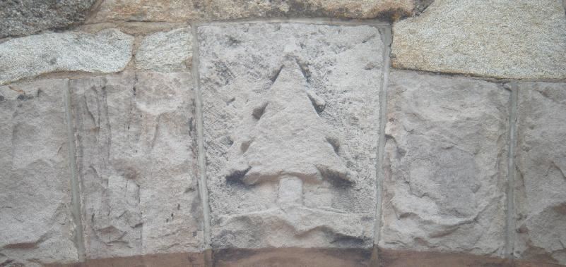
Apishapa Arch The Spanish Peaks area in southern Colorado is world-famous for its radial dike geologic features. Radiating outward from the summit of West Spanish Peak, the dikes form long, straight rocky ridges just a few meters thick. Long ago, southern Colorado was an area of shallow seas. Mountains to the west shed huge amounts of sediment towards the east, covering the region with thousands of feet of mud, sand, and gravel. Various mountain-building episodes finally raised Colorado well above sea level, deforming, tilting, and eroding the sediments. More recently, tectonic stresses have caused faulting to occur. The Sangre de Cristo Mountains were pushed upwards, while the San Luis Valley dropped down. The whole region rose even higher above sea level. Molten rock seeped up from below, filling cracks and other weak areas. In many places, volcanoes formed during eruptions. In other areas, the magma cooled and solidified before it reached the surface. Approximately 27 million years ago, the area of the Spanish Peaks was still covered by many thousands of feet of sediments when it was invaded by magma. The magma forced its way into cracks in the rock. It also spread along weak layers in the sedimentary rocks. As the magma spread upward in a few spots, the surrounding rocks cracked in a radial pattern. Magma then filled these new cracks. As far as anyone can tell, the magma under the Spanish Peaks never reached the surface to form volcanoes. Instead, it froze in place to form intrusive igneous rock. Several different magmas intruded over the years, forming granites, granodiorites, and syenodiorites. With continuing uplift, the surrounding sediments eroded away. However, the Spanish Peaks themselves were resistant. The hard igneous rock was less prone to being eroded. Also, the magma cooked the nearby sediments, making them more resistant than the softer sediments elsewhere. Now the Spanish Peaks tower above the neighboring valleys. They display their interesting geologic history to all who wish to look. The main intrusions are called stocks -- small masses of intrusive igenous rocks. They can easily be seen in the areas of the Spanish Peaks that are above timberline. The filled cracks are called dikes -- a sheet-like intrusion, usually fairly narrow. The dikes are quite prominent in the area. Many radiate outwards like spokes from the central intrusions of the Spanish Peaks region. Since they are more resistant to erosion than the nearby sediments, they appear to be walls of rock that are visible from miles away. They range from 1 to 100 feet wide, and can be up to 14 miles long. Some are single dikes, while others are sets of parallel dikes. Some have names, such as Devil's Stairway and Apishapa Arch.
Jose de Jesus Cordova operated a ranch near Aguilar, Colorado in the early 20th century. He dreamed of a road from Aguilar to Cuchara Pass and secured funding for the project in 1928. The road was completed in 1934 and renamed Cordova Pass Road in 1978. One prominent landmark along the way is the Apishapa Arch, a tunnel through one of the igneous dikes on the slopes of the Spanish Peaks. To reach the Earchcache site, take State Highway 12 (Highway of Legends) to the top of Cuchara Pass, then turn east on County Road 46 and drive 9.9 miles to the Arch. CR46 is passable in a typical passenger vehicle during summer months, but is closed in winter. To log this Earthcache, observe the dike and surrounding rock and email the following observations.
Add cache to watch list Log your visit Picture Gallery
GC2FHGG Devil's Stairsteps (10.92 kms N) GCP5FK Byways Second Mace (79.97 kms N) GC3KY31 Charles Autobees (107.36 kms N) GC3M26V Annie Blake (107.62 kms N) GC3KY38 Gervacio Nolan (107.82 kms N) |
Driving Directions
9 Logs:
The Bride and I had weddings in Kansas City on June 21st and then another one in Omaha on June 29th. I told her I really wasn’t interested in driving to Kansas City and driving home for 9 hours and then a few days later drive all the way back same direction for 13 hours. So we decided we would take a mini vacation in between weddings and head to Colorado for a week. We rented a car, but little did we know the car was going to be a Cadillac sedan, and I’m thinking this is going to be my caching mobile for this trip.###So over the course of the 11 days, we visited 10 states. I was able to get 5 caches that were Year 2000 including Mingo. I was able to get the oldest cache in 3 states…Kansas, Colorado and New Mexico. Colored the state of New Mexico RED and put 3940 miles on the rental car. ### This trip started out in Kansas City as the wedding was on Friday. So we cached the morning of Friday and did the Powercat challenges near Gladstone area. Loved walking the sidewalk, we did get a downpour on us, so hoped into a local spot for lunch and then once the rains lifted we went hiking again. Then went to the wedding on Friday night. Then next day on Saturday, went caching with Gnomecat, Louinliberty and Debrajean grabbing a few caches that I had handpicked out. Was great to see my KC friends for the 2nd weekend in a row after the previous week in Indiana and by the end of this trip it will be 3 weeks in a row. Had an amazing dinner at Gnomecats and enjoyed the great hospitality.Then on Sunday June 23 is where the journey begins. We headed towards Colorado Springs and grabbed Mingo on the way there. This day was about 9 hours of driving and grabbed a few caches in the Colorado Springs area before meeting up with friends in the afternoon.Monday June 24 was always going to be a big day both driving and hiking. We started it off by going to Paul Barkley (2nd 2000 year cache). Got lucky as that section of the park was closed to people on Tuesday due to electric work being done. Then from there the Cadillac took us to Geocache (3rd 2000 cache). Then after that we headed to Albuquerque, New Mexico.Tuesday June 25 we cached in Albuquerque in the morning doing a few wherigos and then headed over to the oldest cache in the state. Found the place to park and made the short hike up the hill. Then went across the way and did the Hangman hiking series. After we completed that we headed to Santa Fe to visit and then back to Colorado Springs.Wednesday June 26th, we got up and headed off to Tarryall (4th 2000 year), those that get nervous about driving well the Cadillac made it just fine. After that we headed to Pikes Peak, it opened late because the car race practice was that morning. We drove up to mile 16 and then shuttle to the top because of the renovations to the new visitor center at top. After this we are now heading back East. We get to Kansas and find Airakee and then spend the night in Kearney. I was able to watch on the phone Vanderbilt win the World Series…Go Vandy BoysThursday June 27, drive to Omaha and meet the KC crew for the 3 week in a row and we drive to Sioux Falls to get the State Bird.Friday June 28th, finish the last 21 of the Ficks Fizzy we had left. Bad news was on 61 Gnomecat fell in the ditch and went over his head in the water. The ditch had probably 8ft of water. Then headed to Omaha and did some challenges and parted waysSaturday June 29th, some light caching before wedding and then came home on Sunday 13.5 hour drive.Thanks to all the hiders. Earthcaches and Virtuals have sent answers. Challenges will either have a picture or available via public profile. Was able to leave my signature pencil in a few caches. Thanks for the cache-signed log.
|