GC5V3N3 Traditional Cache Teewinot's Meadow
Type: Traditional | Size: Small Small | Difficulty: 1.5 out of 5 | Terrain: 4.5 out of 5
By: Denali41 @ | Hide Date: 04/30/2015 | Status: Available
Country: United States | State: Colorado
Coordinates: N40° 24.425 W105° 16.489 | Last updated: 08/30/2019 | Fav points: 0
Dogs  Takes more than an hour  Scenic view  Significant hike  Hunting  Medium hike (1km-10km) 

I've always been blessed by having superb mountain dogs that have loved hiking and climbing with me. The last two have also been marvelous companions on geocaching hunts and on cache placement hikes. For almost a decade, my puppy Teewinot was a remarkable and accomplished backcountry companion. She climbed hundreds of mountains and was with me on our discovery of thousands of geocaches in Colorado and around the US. Her enthusiasm never waned. But more than 2 years ago a back leg was injured, taking her out of the geocaching and hiking game; Denali50 and I reluctantly replaced her mountainering function with a new puppy, Orizaba. But Tee still gets very excited when she sees me assembling hiking gear, even though she's resigned to staying home while Zaba and I go out for the fun times that Tee would love to continue experiencing.


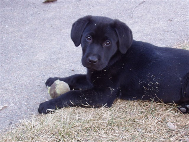
MY PUPPY TEEWINOT WHEN SHE WAS REALLY A PUPPY!!


I thought about Teewinot a lot on a recent backcountry hike with friends, Zaba, and two other "mountain" dogs. We visited some rugged backcountry sites and a series of nice meadows that gave special complementary character to the mountain forests we were climbing through. This would have been a special hike for Tee, because she always loved the transitions of breaking out of dense forests into mountain parks and meadows. Meadows and alpine tundra environments were simply her "thing"! So on this day, as we emerged from a stint of bushwhacking into a nice opening that Tee would have loved, I decided to hide a tribute cache for her--on a meadow she's never visited.

The cache is a small container that's wrapped in black tape. It's covered by a "blanket" of Ponderosa Pine cones, and should be an easy find--even though there is considerable signal variation in the immediate vicinity. Use your geosenses and you'll have it in hand quickly. Bring a pencil or pen to sign the log, and then re-cover it carefully with the pine cones.

The cache is located in a relatively remote area. It cannot be reached by following trails all the way, so it's a good idea that you map out your anticipated route carefully and leave a copy of your map with someone who knows your overall plan. Have fun reaching Teewinot's Meadow, and finding the cache!

More Info

 Custom URLs

Add cache to watch list
Log your visit
Picture Gallery

 Nearby Caches

GC5TX6C Orizaba's Waterfall (0.66 kms E)
GCA80ME Middle o' Nowhere (13.37 kms E)
GC7NYGJ A Geocache a Day ... (19.08 kms E)
GC3JBXN Wind Break...huh! (20.09 kms NE)
GC4B1R8 Cache In Trash Out - Recycled ! (21.49 kms NE)


Driving Directions

 Logs

5 Logs: Found it 5  

Found it 05/04/2016 By jaredandkayla
Found the meadow and the cache both in great shape on this beautiful spring day! The following information may be considered spoiler by some, so if you're like me and enjoy researching and mapping out your own route to these backcountry caches, you may not want to read the rest of my log entry:

There actually is a trail that will take you all the way to this cache. My map calls it the Grim Gulch Trail. I've attached a screenshot of said map as seen on my phone, together with the GPS track I followed along that trail. As a matter of fact, if you look at the map of this cache on this very site and change the map layer to Thunderforest Landscape, you'll see the same trail. The trail is admittedly faint in spots, but I found it surprisingly "traily" in most places. To follow the trail, park at the turnout near the end of the double lanes, as others have noted. Walk west out of that turnout and you'll see the trail leading up that hill. Before very long, a bit after passing a barbed wire fence, you'll come to a fork in the trail. The more traveled trail heads in a more direct route up the hill to the left. The less traveled trail skirts around the contour of the hill to the right. Take the less traveled trail to the right. That is the continuous trail and will lead you all the way to the meadow where the cache is hidden. If you take the fork to the left the trail does fade away and end and you may not find the trail again (though you'll be very near it at that point).

This was a great geocache as I love these great backcountry caches that we have here in Colorado. Thank you so much for placing it.

Found it 10/08/2015 By BugRanger
Hiked up with EstesLynne, PathPacer & geo-dog Suzie, starting out on trails, then going cross-country along the contours when those trails petered out. It did get pretty steep in a few areas, but not too bad, overall. Found the little meadow & started the search. Got within about 30 ft of GZ when Estes Lynne made the find. We all signed the log, then debated on the next cache "nearby", which continued our adventure. TFTC!

Found it 10/08/2015 By Path Pacer
That was more of a trek than I thought it would be, after zooming in on the geocaching map and seeing there was a trail at least halfway up Grim Gulch. Turned out to be kind of intermittent and we mostly used the topo map to chart our course, then we slipped down the currently dry Grouse Hollow Creek (or whatever it's called) to the other cache.

We decided to hike out down Grouse Hollow, but that turned out to be harder that if we'd gone back the way we'd come (probably). Trying to skirt the private property down by the road was brutal, and then we had a half-mile walk back up the road to the cars, me with wet feet from slipping into the tiny bit of creek to be found for a mile. Don't go that way. :)

Thanks for the adventure!

Found it 10/08/2015 By EstesLynne
Path Pacer, BugRanger and I hiked up here (with Path Pacer's dog Suzy, continuing the doggie theme), on a beautiful fall morning. We parked at a pulloff at N 40 25.141 W 105 16.439 and went uphill from there, finding faint trails the majority of the way. It was a stiff hike, but we found the cache fairly quickly. We did have to let our GPSr's settle down some before we homed in on it, but geosense helped too.

Then, we thought, how far and how hard could Orizaba's Waterfall be?? Um, we earned out T stars today for sure. For that continuation of today's adventures, see that log! TFTC

Found it 06/07/2015 By jmuser
Wow! Came up today to get this one and Orizaba's Waterfall. What a hike! At least, for us out of shape types! Fantastic views. The springtime wild flowers are out in force. All the colors are there; Blue, purple, yellow, red, white, etc. Also, all the pine trees up there are in full "action" too, and clouds of pine pollen can be seen blowing around. Wrong time of year to be up there if you are allergice to pine pollen. Fortunately, I am not! :-) I attacked these two from the north. I did not hike up Grouse Hollow. I parked about 1/4 mile up the road on the south side, just before the double lanes going uphill end. Found a way from there that got me into the neighborhood. Hiked in through the Viestenz-Smith Mountain Park country. Steep ridges and nice views. Around 4 miles round trip for the hike (including Orizaba's Falls), if the bread crumbs in the GPS aren't fooling me. See the attached pics. Another high quality Denali41 mountain cache! Awesome! Very nice!

This entry was edited by jmuser on Monday, 08 June 2015 at 11:55:34 UTC.