GC5TX6COrizaba's Waterfall
Type: Traditional
| Size: Small
| Difficulty:
| Terrain:
By: Denali41@
| Hide Date: 04/30/2015
| Status: Available
Country: United States
| State: Colorado Coordinates: N40° 24.417 W105° 16.020 | Last updated: 08/30/2019 | Fav points: 0
Recently several friends and I made a hike through spectacular, rugged foothills terrain south of Big Thompson Canyon. We were accompanied by my puppy Orizaba and her two favorite backcountry doggie companions, Brisco and Poudre. We maintained a steady pace that was slow enough for us to enjoy continued conversation while we appreciated the gorgeous weather and the scenic country we were traversing. The loop we chose was all off-trail, involving bushwhacking, stream crossings, and some nice rock scrambling. We encountered no other people during the 7-mile hike that included more than 2,500 feet of cumulative elevation gain. It was as close-to-perfect a time in the lower mountains of the northern Front Range as one could hope for.
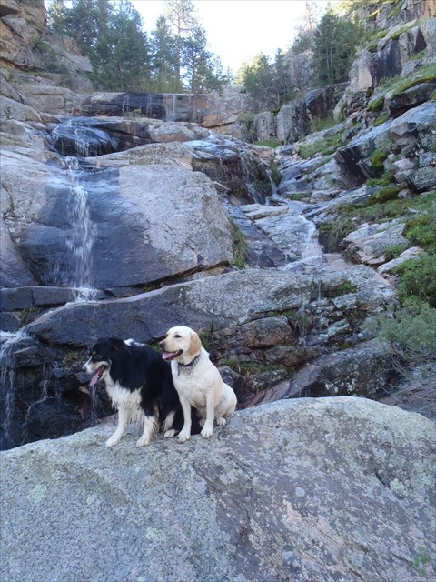
Partway along our route we came on an unexpected surprise–a marvelous waterfall where the stream’s water cascaded over several rocky cliffs and narrow benches. Recent snow melt and rain added sufficient flow to provide natural “music” as well as captivating visual images of the plunging waters. We stood and marveled at the beauty of this hidden place, a spot very few people visit, and we felt fortunate to be here together. What we initially failed to notice were the reactions by our puppies to this special setting. They played in the cascade’s pools, and eventually Orizaba jumped onto a prominent rock and posed for us directly in front of the falls. She was obviously having a great experience. Shortly, she was joined on the boulder by her buddy Brisco. But Zaba had clearly laid claim to the situation, and it was natural to proclaim this as Orizaba’s waterfall!
BRISCO AND ZABA AT ORIZABA'S WATERFALL
After we crossed the stream and scrambled up the steep, rocky slope to gain the top of the falls, we reached a small flat area. Wow! What a place for a geocache: “Orizaba’s Waterfall" cache. So as friends and doggies showed their patience, I hid a cache in this very special location. It’s a small jar wrapped in black tape, and contains no pencil or pen–so bring your own. The area at and near ground zero has its signal markedly affected by nearby cliffs, with the coordinate “fix” showing wide swings between 15 and 35 feet. So follow these hints and look at the spoiler photo to nail this nice cache: the cache is above the falls on the right side (facing upstream). It’s at the base of a steep slope of large rocks and boulders adjacent to a solitary Ponderosa Pine tree that’s at the immediate bottom of the steep terrain. Look in a nook of the rock wall directly behind the pine. It’s covered by several sticks. Be certain to re-cover the cache carefully after you’ve signed its log.
The area is relatively remote, so after you’ve mapped out your intended route to the waterfall and cache location, it would be wise to leave a copy of the map with someone who is aware of where you are going. Be careful, be safe, and have fun. Orizaba’s waterfall is a special place, and the cache is made special because of the place.
05/21/2017 By Denali41 Joe Grim hiked to the waterfall today to see it in its full cascading beauty after the recent heavy rain and snow. The beautiful Ponderosa Pine tree that protected the cache was taken down by the recent storm. Joe saw the container on the ground and re-hid it--directly in the cavity that developed at the base of the tree when it fell. So look for the cache there, at the original coordinates but in a different "position" than is shown in the spoiler photo. Thanks, Joe!
05/04/2016 By jaredandkayla Great hike to a great location on this day with great weather! If you've read the logs on the "meadow" cache you'll see that I did manage to follow a trail all the way to the meadow. That same trail actually continues east out of the meadow in the direction of this cache. I chose to follow it. That was a mistake. The trail runs along the south side of the stream for a bit before meandering further southeast and higher up the ridge away from the stream. Following the trail gets you in the general vicinity of the cache, but you are too far south (uphill from the cache), and the terrain between the cache and the trail is very steep and rugged. I traversed that terrain by first shimmying down the mountain to the stream. I then followed the stream but it comes to a shelf that is about 10 feet high at its lowest spot. I couldn't find a good place to let myself down that cliff. I had to hike west from there, back up the mountainside and around before I could turn back east toward the cache. I eventually got there, but in this case, the trail made it harder than it needed to be. I'd recommend a straight east route from the meadow to this cache. Much easier and you'll miss the shelf.
10/08/2015 By BugRanger After the steep hike up to Teewinot's Meadow, Estes Lynne & I talked PathPacer into going for this cache, even though she'd already tagged it a month ago. I figured it was downhill, and sorta on the way back, and she said there was a trail after a bit, so no problem, right? OMG!
We started out well, then started into the rock scrambles getting into the ravine & creek bed. Going through the rocks -and brush & stickers - to get to the waterfall areas, I was grateful that there was very little water in the creek. Lots of route-finding work, especially getting around both the upper waterfalls & lower falls. When we got to 140 ft of GZ, Path Pacer pointed up the hill, and gave us the "spoiler" hint on where to search. Another scramble uphill, but we made the find :-)
A bit more route-finding to the base of the lower falls, and then we found the trail down. We really weren't sure of the property lines (only very few signs, and several barbed-wire fences), but when we saw the wildlife camera, we figured we were close (or in a hunting area), so ended up bush-whacking through the creek bed to end the hike at the road. Just another 1/2 mile walk back uphill to the cars. What an adventure! TFTC.
10/08/2015 By EstesLynne After scoring Teewinot's Meadow, BugRanger and I talked Path Pacer into heading over to this one (PP had done it from a different approach a month or so ago). I mean, how hard could it be?!
Well, hard. We earned our T stars big-time here--lots of rock scrambling, route-finding, bum hiking (as Aussies would say), and (unfortunately) cactus-sitting. And a little barbed-wire-fence crossing as we attempted to stay clear of private property on the descent. Not sure we were completely successful in that one, but we tried. In the end, we found the cache, of course.
I second the comments about making sure someone knows where you are back here. That being said, it's a lovely area with that "secret, special place" feel to it. TFTC!
09/18/2015 By Path Pacer It was a tough hike up to this one. As expected, the falls were dry, but it was still a fun place to explore, full of little pools and different plants from the arid hills above. Sadly, my geo-dog has sore knees and had to stay home to rest. A local told me the rental properties at the bottom of the gulch were built in the '40s as a resort. In the early '80s, a group hiked up to the falls and a girl fell off them and died. As I was crawling around on the rocks, I can see why; those rocks are quite slick, even when dry. That spot has history.
The cache was higher up the slope than I was expecting, but my GPS lead me right to it (I didn't believe it at first). I thought about hiking on to the meadow, but decided to leave that for another day. Thanks for an interesting cache; I'd never have known about Grouse Hollow without it.
 Orizaba's Waterfall
 | Difficulty:
  | Terrain:


")