|
GC3GJ2Z
 Bathtub Ring
Type: Earth | Size: Not chosen  | Difficulty:
  | Terrain:
  By: jp66 @ | Hide Date: 04/07/2012 | Status: Available Country: United States | State: Colorado Coordinates: N39° 20.387 W104° 45.261 | Last updated: 08/30/2019 | Fav points: 0 


")

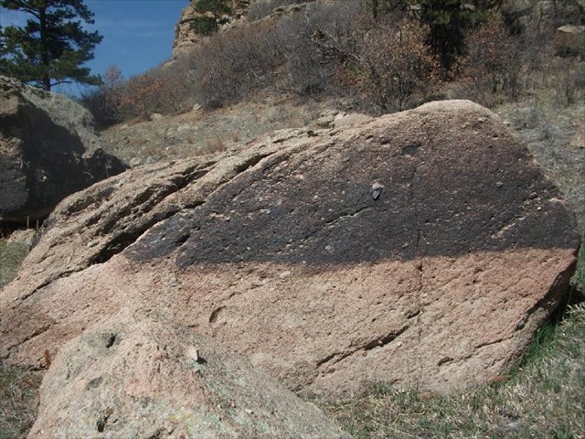
The Bathtub Ring 1890-1933. That's how long it lasted. The dam at Castlewood Canyon is one of the historic features of this park. Finished in 1890, it dammed Cherry Creek to produce a lake some called Lake Louisa. The water stored here was used for irrigation, recreation, and other local needs. The dam leaked from the beginning. It finally failed after a long bout of rain in August of 1933, sending a wall of water down the Cherry Creek Valley and all the way through downtown Denver. It was never rebuilt. The ruins are one of the attractions here at the park, and are the subject of a virtual cache (Douglas #11 Castlewood Dam). The lake level varied through the year, sometimes high and sometimes low. Although it was only in existence for 43 years, that was long enough to leave its mark on the landscape. This earthcache will show you one of those marks. At this first stop, take a look at the boulder in front of you. It is striped -- black above, reddish below. Look around for other boulders at approximately the same elevation -- do you see similar lines separating black above and the much paler rock below?
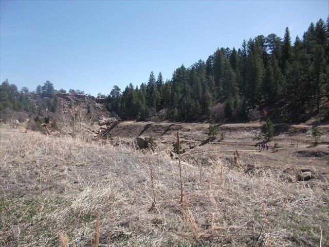
Cross the creek, looking upstream as you do so. Travel to the second stop and look around. You will see even more boulders with this stripe. Also, you will see a faint horizontal line across the landscape at the exact same elevation. It marks the beginning stages of a lacustrine terrace (i.e. lake terrace). This is the former lake level, the former shoreline and the beginnings of a beach.
(If you are having trouble seeing the approximate line that marks the terrace, click here to view the same photo with a dashed line indicating the approximate level of the terrace at the same elevation as the boulders.) The black coating on the rock is a type of weathering often called "rock varnish". It is very thin and rich in manganese oxide. It is produced by various microbes that live on the rock. It is common in semi-arid areas, on surfaces that are protected from wind and excessive precipitation. In Castlewood Canyon State Park, you can see it on rocks that are near the current creek, as well as on these higher, now-dry boulders. The black coating is above the water level, while the rocks under the waterline were stripped clean. Why is this of geologic interest? If you travel throughout the western United States, you will see areas with similar features, on a much larger scale. Much of the western United States contains closed basins, areas that collected water faster than it could evaporate or drain out. Many of these basins have sets of parallel lines that show the levels of the former lake that filled them, with the different lines corresponding to different lake levels. These lacustrine terraces are important for understanding our past climate since the lake levels were exquisitely sensitive to variations in temperature and rainfall. They can also help to indicate and date geologic events that have occurred since the terrace formed. For example, if the line of the terrace is offset or tilted, perhaps the underlying region has tilted or faulted since that time. Lake terraces are thought to form as wind-driven waves carve steps into the hillsides whenever the water level is stationary. As can be seen here, that process can happen very quickly. Rock varnish is another geologic feature that can be seen throughout the western United States. It can be age-dated and analyzed. By looking at its chemical and isotopic composition, the thickness of the layers in the varnish, and its texture, much can be discerned about the conditions in which it formed, and thus, the regional history. For a long time, it was thought that rock varnish formed over a long period of time, as in centuries to millenia. However, as was eventually determined, and as you can see from the evidence in front of you, it can form in mere decades. To log this cache, please do the following: 1. You are encouraged but not required to post a photo of yourself, your GPS, or some other interesting artifact (i.e. your teddy bear) next to one of the boulders that shows this "bathtub ring" line. It doesn't have to be any particular rock, just one with the stripe! Any of the appropriate boulders along the former lakeshore are acceptable. 2. Look at a few of the boulders in the area. How sharp and horizontal is the line separating the black from the non-black? Very sharp? Gradational over a few millimeters or centimeters? Why do you think it is that way (think about wind and waves and varying water levels)? How about the top of the black area? Is it as sharp as the bottom? More gradational? Is it darker or lighter than the rock varnish near the bottom? Is the line perfectly horizontal? Somewhat non-horizontal or variable? Why do you think this is so? (think about distance above water, weathering since the lake drained, north vs south facing direction, human interference, or other ideas) What is the approximate height of the black area from base to top? Is it fairly consistent from boulder to boulder or is it quite variable? Notice that some of the boulders in the area do not have any black coating or a line separating black from not-black. Why do you think that is? Please send me your ideas and the reasoning behind them. (think about what might have happened since the rock varnish formed.) 3. How many lake terraces do you see? Why do you think there are (or are not) more than one? How long do you estimate it took for the terrace(s) to be created, given your knowledge of how long the lake existed? What does that say about how easy or hard it is to erode the rocks at the level of the former lake? 4. (Optional) If you hike along the Inner Creek Trail to or from this earthcache, keep an eye out for rocks in the creek that are coated with this black varnish. If you find some, note the coordinates. Which side of the rock is the black coating on? Do you mostly find it on surfaces that are wet or dry, sunny or shady, exposed or sheltered? Send me the coordinates of one such spot. If you'd like, you can take and post a photo of it in your online log. For most of these questions, I am not looking for One Right Answer. I would like you to look at the bathtub ring here and think about what you are looking at. The rocks here tell a story, and we can read some of that story if we look carefully. This is a small-scale example of something that occurred on a much larger scale elsewhere in the US. We know the actual history of this area, and thus can learn something about how quickly and under what conditions lake terraces and rock varnish form. Hopefully you will recognize these features when you encounter them elsewhere in your travels. Thanks to sassydil, animjason, and ceolmhor for their assistance in developing this earthcache. This is one of a series of earthcaches located within Castlewood Canyon State Park. The series was developed to show hikers and casual visitors interesting geologic features within the park. The earthcaches highlight sites that display the history of the region. Some are wheelchair accessible, while others take you along the trail system to more remote regions of the park. You are encouraged to do as many as you wish! This and the other Castlewood Canyon State Park Earthcaches were made possible with the cooperation and amazing assistance of THE CASTLEWOOD CANYON STATE PARK VOLUNTEER STAFF! Thank you!!! This Earthcache is located at Castlewood Canyon State Park. Please visit their website for more information about this Colorado treasure. All vehicles must purchase a parks pass. Castlewood Canyon Fees: $7.00 daily fee if you don't have an Annual Pass. Park hours vary throughout the year but typically are from 8am to sunset. Please call the park or check their site for up-to-date information. References: A good online article about rock varnish is Arizona Geology, v 22, n 1, spring 1992, "ROCK VARNISH AND DESERT PAVEMENT PROVIDE GEOLOGICAL AND ARCHAEOLOGICAL RECORDS", by Evelyn M. VandenDolder, Arizona Geological Survey www.azgs.az.gov/arizona_geology/archived_issues/Spring_1992.pdf Additional Waypoints BR3GJ2Z - Creek OverlookN 39° 20.381 W 104° 45.252
Add cache to watch list Log your visit Picture Gallery
GC85Z12 Open 24-7 (14.01 kms NW) GC51FGZ Sleeping Cottonwood (19.19 kms N) GC98W58 Hare Today, Goon Tomorrow (20.37 kms N) GC5201J State Capital series: Juneau, Alaska (21.54 kms SE) GCA6Y93 Green belt cache (21.60 kms N) |
Driving Directions
9 Logs:
|