|
GC23EMK
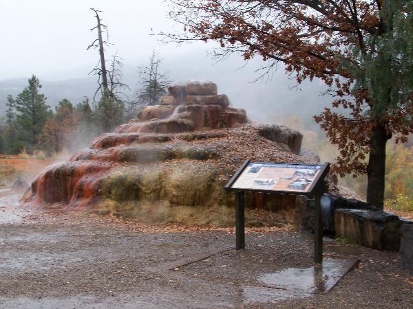
 Pinkerton Hot Springs
Type: Earth | Size: Not chosen  | Difficulty:
  | Terrain:
  By: StumpAuthor @ | Hide Date: 01/29/2010 | Status: Available Country: United States | State: Colorado Coordinates: N37° 27.061 W107° 48.319 | Last updated: 08/30/2019 | Fav points: 0 


is located along Colorado State Highway 550 about 12 miles north of Durango, Colorado in La Plata County and San Juan National Forest in the edge of the rugged San Juan Mountains on the San Juan Skyway
In geological terms, mountain-building activity in the area occurred recently, leaving the earth's crust close to the surface very warm even today. The intrusions also faulted the sedimentary, metamorphic, and igneous rock formations that were already in the area, leaving deep fractures into the earth. Two such faults are mapped just northeast of the Pinkerton Hot Springs. Surface water from precipitation and runoff infiltrates through the permeable surface soils and sedimentary rocks, picking up minerals through dissolution on its way. Some of the water eventually finds its way into one of these deep fractures where it encounters warm igneous rock that was once magma. The heated water then returns to the surface to spill out as a hot spring, and deposits the minerals it acquired during its journey behind as it evaporates.
The Colorado Department of Transportation (CDOT) modified the outflow around 2001 to manage the water flow, keep it from affecting the stability of the roadway, preserve its historical value, and maintain the hot spring environment.1,2 Thus, although hot springs naturally form mounds, this particular mound is not a natural formation, but is a cairn. However, the department only "re-routed" the conduit and stacked the rocks. Nature did the rest, including covering the mound with the myriad of colors and shapes there today. Less than 100 yards northwest, on the west side of the highway (N37° 27' 11.58", W107° 48' 20.87"), a natural mound formation remains unmoved by man and it is easy to compare what part of the fountain by the road is natural and what part is not. Hot springs are sought for their natural beauty, heat, ecological diversity, and balneotherapy. Some believe that the minerals carried in the water are beneficial to the skin and, combined with the natural heat, can even help such health issues as arthritis. The microclimate around a hot spring attracts a large variety of plant and animal life not found elsewhere in the surrounding environment, noticeably so during the winter. Hot springs can also provide a source of energy for commercial and residential applications, such as interior heating. 
For those technically minded folks, according to the Department of Energy in 19811, the Pinkerton fracture served as a geothermal reservoir (image credit) approximately 1,000 feet thick and covering an aerial extent of approximately 1.2 square miles, producing an estimated total energy on the order of 0.99x10¹³ to 2.09x10¹³ BTU's. The energy available from this hot spring complex is comparable to about 120 million gallons of gasoline or 14 billion cubic feet of natural gas.4 For perspective, the average natural gas consumer uses about 319,000 cubic feet of natural gas each year in Colorado.5 The hot springs represent a very significant potential source of sustainable/renewable energy. When sampled in 1976,1 the water temperature at the surface was 32°C (90°F), flowing at about 54 gallons per minute (gpm), and below the surface was estimated to be 50°C (122°F). The water contained 3,700 to 3,980 parts per million (ppm, or mg/L) dissolved solids, including minerals such as Arsenic, Boron, Cadmium, Calcium, Chloride, Fluoride, Iron, Lithium, Magnesium, Manganese, Nitrogen, Phosphate, Potassium, Silica, Sodium, Sulfate, Calcium Carbonate and Bicarbonate, and other noncarbonate minerals. It had a pH balance of 6.5, which is slightly acidic (Rainbow Trout begin to die at pH levels of 6.0 or less4, in case you are interested). Hot springs even contain organic life in the form of anaerobic bacteria that help break down the minerals and, when exposed to the surface, provide an excellent fertilizer for algae and other plant life. Drinking the water is discouraged because its properties probably fluctuate and it is not regularly tested for consumption. Drinking from the spring should be avoided. Logging Questions: Based on your reading of the Colorado Scenic Byways roadside interpretive exhibit: 1. For what purpose was the water bottled in the late 1800's? 2. What did Judge Pinkerton use the hot springs for in the 1870's? Based on your observations: 3.
What specific kind of plant life is growing on
the side of the mound? 
Other Educational Information: References: 1. Coe, Barbara A., & Zimmerman, Judy. (1981). Geothermal Energy Opportunities at Four Colorado Towns. Colorado Geological Survey, Dept. of Nat. Resources, for the USDOE. 2. Steve, T. A., et. Al. (1974). Geologic Map of the Durango Quadrangle, Southwestern Colorado. Department of the Interior: United States Geological Survey. Scale: 1:250,000. 3. Mountain Studies Institute. (n.d.). San Juan Mountains. Available at http://www.mountainstudies.org/SanJuanMountains/. Accessed October 20, 2009. 4. EPA. (n.d.) pH Scale. Available at http://www.epa.gov/acidrain/education/site_students/phscale.html. Accessed October 20, 2009. 5. Nave, Carl R. (2006). HyperPhysics: Energy Unit Comparison. Online calculator application. Availabe at http://hyperphysics.phy-astr.gsu.edu/Hbase/egex.html#eu. Accessed October 20, 2009. Georgia University, Dept. Physics and Astronomy. 6. Energy Information Administration. (2007, 2008). Natural Gas Navigator: Consumption. Available at http://tonto.eia.doe.gov/dnav/ng/ng_sum_top.asp. Accessed October 20, 2009. Note: Total consumption for Colorado (2008) of 504,786 million cubic feet divided by total number of consumers (2007) of 1,583,945 = approximately 318,689 cubic feet consumption per consumer, annually, for both residential and commercial application. 7. CDOT. (2010). Email conversation. CDOT guesses the cairn was constructed in 2001, but not as part of the highway construction.
Add cache to watch list Log your visit Picture Gallery
[For #1 and #2,] read the sign. [For #3,] Anaerobic bacteria fertilize what?
GC2N2WK Agri Cascade (78.50 kms N) GC5M10N OC#4 Orchard City Limits (149.27 kms N) GC3BT6A Ski Fever (174.13 kms NE) GC7HQGY Four Mile School (254.40 kms NE) GC45417 Those Vermin (254.62 kms NE) |
Driving Directions
11 Logs:
|
 The mountains surrounding
Pinkerton Hot Springs have a geological history "as varied as
that of any mountain range in the world,"
The mountains surrounding
Pinkerton Hot Springs have a geological history "as varied as
that of any mountain range in the world," To
qualify as a hot spring, the water temperature must be warmer than
the ambient temperature of the surface soils (
To
qualify as a hot spring, the water temperature must be warmer than
the ambient temperature of the surface soils (