I have a new email friend whom I call “KT”. That’s not my new email acquaintance’s actual name, but it will do. KT emailed me claiming to be an excellent navigator. Of course effective navigation requires multifaceted skills, including knowing where to find and how to use salient map and other resources needed to determine possible routes to a destination--and from these options to chose the optimal route plus the tools needed to calculate coordinates and to achieve the destination of the cache hide. Recent episodes suggest that KT could benefit by refining his/her navigational skills, so I have developed several scenarios that can serve as checkpoints in establishing a reasonable portfolio of expertise. This is the seventh scenario. It is preceded and will be followed by others that employ additional facets of navigational techniques. The cache descriptions are not “instructional”; instead, they provide opportunities for the cache seeker to explore navigational solutions to attain success in calculating and getting to a cache’s coordinates. For those seekers who already possess the basic skills, developing a plan to reach each of the caches should be straight forward.
This cache is hidden above Big Thompson Canyon between Crosier Mountain and Crosier Dome. It's on a rock formation informally known as "The Camel", or "The Dromedery". You must work through the specified steps in order to determine the cache’s actual location. But first, use available navigational materials to determine a logical place to park and to plot out a good hiking route to the listed coordinates. Be careful as you chose your parking and approach route so you remain on US National Forest land for your entire journey. With proper attention to details as you do your map work, you can find logical routes that never stray from USFS property. Then make the hike to this starting point, the listed coordinates. Use the information below to determine the specific location of the cache.
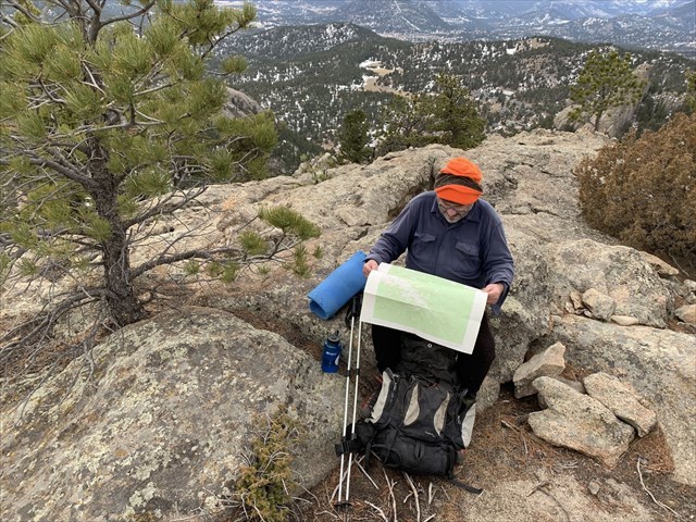
When you reach the listed coordinates spend some time admiring the awesome views of the mountains in Rocky Mountain National Park that display so beautifully from your location! After becoming temporarily sated with these views look nearby to find where you next need to go. Study the photo on this cache page that shows muggle Dave studying his USGS 7.5-Minute Quadrangle of the area. Determine the exact location where he was sitting, and go to it. You are now 221,040 mils at 2946 mils from the cache location. Make your calculations and then go find the cache. It's a quart-sized container. Sign the log and then return to the general summit area to enjoy more of the scenery.
This cache involves a hike on moderately steep terrain and requires a very small amount of scrambling where some people will want to use both feet and hands for short stretches. Plan to hike a bit more than 3.5 miles RT while ascending about 1,500 feet of elevation. Enjoy your time getting to and in the cache vicinity. And enjoy finding and logging the cache!
Additional Waypoints
 A Navigational Challenge for KT--7
 | Difficulty:
  | Terrain:


")
