GC6WY6B Unknown Cache Mt. McConnel Fun
Type: Mystery | Size: Regular Regular | Difficulty: 4 out of 5 | Terrain: 3.5 out of 5
By: ArkF @ | Hide Date: 11/12/2016 | Status: Available
Country: United States | State: Colorado
Coordinates: N40° 40.326 W105° 27.864 | Last updated: 08/30/2019 | Fav points: 0
Dogs  Takes more than an hour  Scenic view  Field Puzzle  Medium hike (1km-10km) 

Finding this cache entails hiking up Mt. McConnel, locating several peaks, and using map skills to identify the cache location.

I had a fun time hiking up Mt. McConnel, and while I was up there I hid a cache that will hopefully be fun for other people as well! A while back I found "A View to a Cache" (GC12WK3) in Wyoming and was inspired to hide something similar, but with more hiking and a bit of a twist.

The first task for this cache is to hike to the top of Mt. McConnel, which is in the Cache La Poudre Wilderness. The hike to the top is around 2.5 miles, with a net elevation gain of about 1300 ft. There are a few other caches you can pick up on the way, with multiple route choices starting from the trailhead at the Mountain Park campground.

Once you reach the summit and have had a chance to catch your breath and enjoy the 360° views, its time for the hard part. The cache description has 4 pictures attached, each one showing a nearby peak. The red arrows highlight the specific peak. You need to use your observation skills, along with a map and compass, to identify each peak. Obviously, this will be harder on a cloudy or foggy day, and if visibility is too low, it will be impossible, so plan your attempt accordingly. All of the peaks lie in the box defined by N 40° 38.5', N 40° 42.0', W 105° 26.0', and W 105° 29.5'. Once you know which four peaks go with the pictures, you can plot a bearing from each peak to the cache site.

The four bearings to use are:
  • 83.80° T
  • 19.67° T
  • 304.05° T
  • 336.77° T

It is up to you to decide which bearing should go with which peak, there should only be one reasonable way to do it. Keep in mind, these are bearings FROM the peak, TO the cache.

Once you have your bearings, draw them on your map (or use your GPS if it can handle this sort of thing, mine can't). Where they intersect, you will find the cache. You can find the cache with as few as two bearings, four are provided to allow for a failure to identify one or two peaks, or to add redundancy and reduce the chance for error in the plotting process.

If this sort of thing sounds like fun (and I hope it does!) then come out and enjoy the trails and the wilderness, and practice your mapping skills. I included a pencil in the cache, but the tip broke and I forgot to include a sharpener, so BYOP for now. If something isn't clear, or you have questions or need help, please feel free to contact me through my Geocaching account.


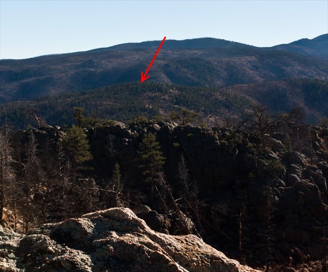
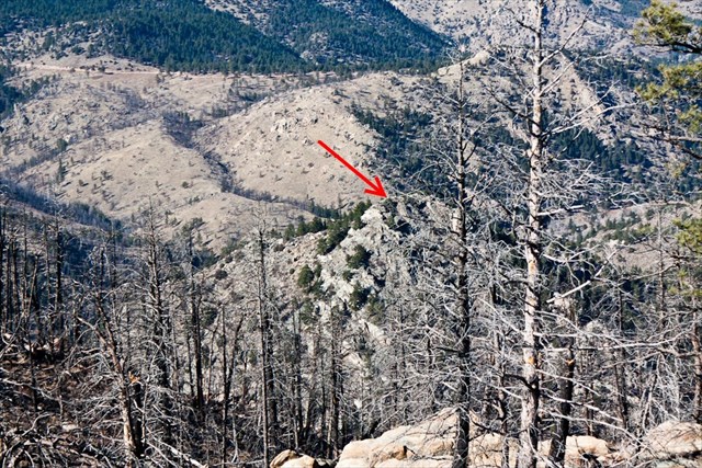
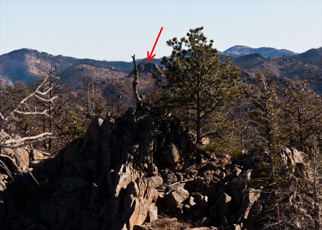
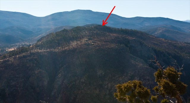
Additional Waypoints

 Custom URLs

Add cache to watch list
Log your visit
Picture Gallery

 Hints

On the northeast side of a medium-sized rock formation, which is itself to the northwest of a larger rock formation. There is an oblong, flat rock topping the rock formation, around six feet long.

 Nearby Caches

GC4RZD1 What's He Looking At? #1 (33.82 kms E)
GC5GDX9 Moose's Random Trails #1 (34.94 kms E)
GC5GDYD Moose Love Puzzles #4 (36.87 kms E)
GC5GE02 Moose Love Puzzles #6 (37.30 kms E)
GCA223E RIF (38.29 kms E)


Driving Directions

 Logs

4 Logs: Found it 2  Didn't find it 1  Publish Listing 1  

Didn't find it 07/11/2017 By runawaytrain
UFO - unable to figure out. Map skills aren't what they used to be - honest effort - IDed 3 peaks but in the end had to settle for alpine wildflowers and a million dollar view. Kudos to Mrs. rt and geomutt for joining the fun. Thanks for the challenging cache.

Found it 11/25/2016 By icezebra11
I took today off work to have a 4-day Thanksgiving weekend and decided to do some caching up Poudre Canyon since my wife had to work on Black Friday. After a nice hike up Roaring Creek in search of Dan Edwards' cache of the same name, I headed back down the canyon to the McConnel trailhead. I had seen this cache the day it was published and knew it was one I'd have to try since I enjoy caches that require some old fashioned mapping. It was a really nice afternoon on the mountain. I had never been on this trail and I really enjoyed the hike.

I had done some preliminary scouting on-line before today and had a good feeling I knew which peaks on the topo map were the ones required. When I was on top of Mt McConnel I verified that I did indeed have the correct peaks identified. My mapping wasn't one of my better efforts but it got me within 40 feet of the final and with the hint, it was a pretty quick find. I signed the log as the STF and then continued on my way. Thanks ArkF for this well done cache and for luring me up Mt McConnel!!!

Found it 11/20/2016 By Denali41
My puppy Orizaba and I went up to the top of Mount McConnel today as the first step in finding this great puzzle cache. I checked my records. It’s the 6th time I’ve hiked to this summit. Years ago, when I was intent on becoming the first person to reach the tops of all 256 of the Ranked Peaks in Larimer County (successfully done), I ascended to the summit of this mountain on several occasions. Why? Well, many of the peak objectives I had in the county had never before been climbed, or had no route descriptions available; only a tiny, tiny percentage had actual trails. I needed clear weather to be able to sort out the most favorable options to reach the summits. Denali Queen and I normally climbed each Tuesday, Thursday, and one day each weekend. So on foggy days when it was infeasible to delineate in the field possible route options on peaks we couldn’t see, we’d do repeats by going up summits that had good trail systems. Greyrock was our favorite, because of its proximity to our homes, and we reached its top a couple of dozen times over the years. McConnel, being farther away, received less attention. So today I returned in circumstances of clear, pleasant weather, and was treated to the magnificent views from the top that I’d repeatedly missed on those previous ascents in heavy fog. Wow, what wonderful scenery Zaba and I had today! Zaba seemed unimpressed with the views; instead, she scurried around the summit area testing all the odors. The extent of her preoccupation demonstrated there were plenty of doggie delights at the top of this mountain–perhaps as many delights as I was experiencing with my eyes. A treasure load of interesting mountains, so many that I’d climbed in those past days of getting to the tops of the ranked peaks in my viewshed.

Well, after considering all this, I quickly identified the four mountains featured in the cache description photos. Quick work with my compass allowed me to find the specific peaks on my map. Out came the protractor, and I was soon ready to find the cache. "Mt. McConnel Fun" WAS "fun", indeed; it was a pleasure to reach my calculated coordinates and discover a log book having no prior names. I signed the cache log as the {FTF} and dropped a Travel Bug in the cache.

Thanks for a very FUN cache, ArkF!! It has deservedly earned a Favorite point.

Publish Listing 11/13/2016 By HighCountryAdmin
Published