01/10/2019 By rangerhal
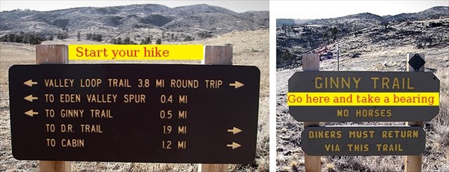
Well started out today heading to the Round Mt. trail to search for some caches I'd been looking at for a while. Got there and the parking lot was closed. No problem pulled into a wide spot off the highway and headed up the hill. We didn't quite get to the trail and a nice young lady met us and told us the trail was closed due to some thinning work. I guess the government shutdown hasn't stopped everything. So, had to figure out plan B. I have also been thinking about the caches up behind Bobcat Ridge and since the other purpose of today's excursion was a hike that seemed like a good alternative. This seemed like a fun multi although the sum of our geocaching tools was our trusty cell phone. Now I've never really done any triangulation with the cell phone, but I figured what the heck. We got to the first bearing point and got the coordinates figuring we could just reverse the bearing to get one line. Headed off to the second bearing point and established a go to bearing and headed off to find the approximate intersection point. After a few minutes of hiking realized I had forgotten to get the coordinates for the second bearing point, but figured I still had 2 lines which should be enough to get close. After a bit of bush whacking we arrived at what I hoped was the GZ for stage 1. Unfortunately though we spent a lot of time looking we never found a container with the coordinates to the final stage. :-( However, not all was bad as we did see a herd of elk and we did find a benchmark and we had a good hike. I'll have to contact the CO to see if we were even close to the actual Stage 1 GZ.
12/18/2018 By Tahosa and Sons
Depositing a trackable for a short visit.
 05/05/2017 By Cache U
Well, I always seem to be late to the party when it comes to completing challenging wilderness caches behind the two usual suspects  ! I tackled this one a few weeks ago during a spring snowstorm. Got to stage 1, and my first instinct proved correct, only I didn't know the one special thing my GPSr could do. But thanks to the CO, I do now! Anyway, made the return trip today without any issues. Lovely spot for a cache, and after logging 10.5 miles today, I'm going to have a beer in Mike's memory (Guiness, of course!). Thanks for a wonderful field puzzle and a great tribute to your brother!
11/20/2016 By icezebra11
I wanted to get up to Bobcat yesterday to go for this cache but I spent the day raking leaves and blowing out my sprinkler system. Fortunately the snow melted off quickly and nothing froze up in this recent cold snap. But today was an even nicer day so after my wife and I took out puppy to the dog wash and cleaned him up, I headed to the Bobcat parking lot. I arrived at the first location, marked the spot, and then sat down at the nearby convenient spot to plot out the location and bearing. After that I headed for location #2. That's when my progress slowed somewhat but after a bit of contemplation, I plotted location #2 and the bearing and I headed for the point of intersection. My plotting was pretty close and I quickly found Stage 1.
With the information from Stage 1 I entered the coordinates for the final stage. It was pretty straightforward for me and I made my way to GZ. Again it was a quick find and the final container was in hand. I was glad I saw through the shenanigans and the malarkey and I happily signed the log book in the STF position. It's nice to find a well-stocked ammo can and I traded TBs.
Thanks Joe for placing this really nice multi. It's a superb tribute to your brother. I'm sure he would enjoy greatly the views at the final location.
11/11/2016 By Denali41
WOW!! This is a very creative cache sequence, and a superb memorial tribute to your brother! After Denali50 and I returned home early in the afternoon from delivering our Meals On Wheels route, I pulled together my map and my mapping tools, packed my backpack with potentially needed items, and headed to Bobcat Ridge. I didn't arrive at the parking lot until 2:30 PM, and frankly was a bit worried about overall timing because the parking gate gets locked at dusk--and I sort of wanted to sleep in our bed tonight instead of in the driver's seat of the tiny Miata I was driving.... But I had an efficient time proceeding through the well-conceived steps necessary to locate the first stage, as well as from that point in determining how to ensure I was heading to correct coordinates for the final. All went well, and I easily was back to parking before dusk.
This is a neat area of Bobcat Ridge, and I had a very pleasant hike reaching the stages--some on trail and a bunch involving bushwhacking. Today's overall experience with this fine multi-cache was fun and very positive.
I took the match stick container as my {FTF} prize. I have plans for it--who knows, it might appear somewhere on September 20, 2017, a milestone birthday for Tahosa. And I also took one of the two travelers in the cache, to be moved along.
Thanks for a marvelous experience!! This one deserves a Favorite point, and it now has one.
 11/10/2016 By HighCountryAdmin
Published
 Mike's Cache
 | Difficulty:
  | Terrain:


")