|
GC2FV7Y
 Dinosaur Footprints on the Skyline
Type: Earth | Size: Not chosen  | Difficulty:
  | Terrain:
  By: neco_cachero & wolfberry23 @ | Hide Date: 09/24/2010 | Status: Available Country: United States | State: Colorado Coordinates: N38░ 27.775 W105░ 15.132 | Last updated: 08/30/2019 | Fav points: 0 We like to bring you to an unique place in the Canon City area that teaches all of us something about Earth history through dinosaur fossilized tracks. It has a magnificent view of the city and highway 50. Who will guess that so high off the ground you might find dinosaur tracks? The Cretaceous WorldThis is the last period of the Mesozoic Era. The Cretaceous follows immediately after the Jurassic Period and it is followed by the Paleogene Period of the Cenozoic Era. It is also better known as the final era of the dinosaurs. A huge mega-worldwide extinction event, ocurred approximately 65.5 million years ago, wiped off in mass scale most animal and plant species in a geologically short period of time. A period with a relatively warm climate and high sea levels, the Cretaceous' oceans and seas were populated with now extinct marine reptiles, and the land by dinosaurs. The Cretaceous Era is divided then into an Early and a Late Epoch. The Paleontologists researching the area estimated that these tracks were made in the Albian Age, the last age of the Early Cretaceous Epoch. Pay attention and read the signs posted at the cache location to tell me how long ago (in millions of years) do the researchers estimate these tracks were made?
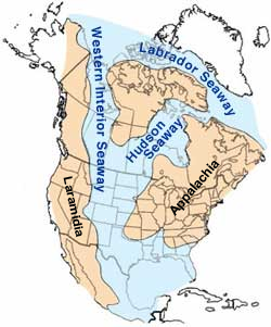
At its deepest, it may have been only 800 or 900 meters deep,
shallow in terms of seas. Two great continental watersheds drained
into it from east and west, diluting its waters and bringing
resources in eroded silt that formed shifting delta
systems along its low-lying coasts. Along the western shore of the
seaway many rivers and waterways easily flooded in and out of the
calmed mass of warm water. There was
some sedimentation on the western shores of the Seaway
where the actual Colorado state eastern side of the Rockies are, as
shown on the map on the right.
Dinosaur Footprints and TracksAs we already know the high eustatic sea level and the warm climate of the Cretaceous meant a large area of the continents was covered by warm shallow seas. This facilitates the proliferation of coastlike vegetation along extensive shallow beaches and river mouths. Reading the signs posted at the cache's location tell me what type of geographical feature do the researchers believe these dinosaurs were wandering on? Look for and think of a type of body of water like a bay, a beach, a gulf, or a delta for example. Dinosaurs walked deep into these shallow waters to find grazing water pastures and to escape from predators. An interesting characteristic of the Cretaceous Era is the proliferation of a particular type of rock. The Cretaceous was named for the extensive chalk deposits of this rock in many parts of the world. Cretaceous means "chalky" in Latin and it consists for a major part of marine limestone, a rock type that is formed under warm, shallow marine circumstances. Due to the high sea level there was extensive accommodation space for sedimentation so that thick deposits could form. Because of the relatively young age and great thickness of the system, Cretaceous rocks crop out in many areas worldwide. The bottom of the Western Interior Seaway was made in part of big deposits of this chalky rock. Calm water allowed sediments from the top to easily sunk to the bottom increasing its layer through millions of years. Through this sedimentation process the bottom of the seaway was slowly transformed into a huge blank ready to be imprinted. Different land animals that approached the water to drink or eat the plants left their footprints on the chalky bottom. Eventually after millions of years the seaway was slowly drained through east and west watersheds leaving behind a thick layer of chalk and sediment. Once exposed to the sun and atmospher it quickly drained and solidify preserving most of what was buried and covered by the sediments.
Geography of the US in the Late Cretaceous Period By the period when these tracks were made this area was on the edge of the Western Interior Seaway, a group of dinosaurs were walking side by side through the mud along together probably eating the plants. Can you tell me what type of dinosaur left the footprints? Their tracks then were slowly filled in by silt, sand and plant debris, which later hardened to preserve everything in it as casts of the actual tracks. Dinosaurs walking on the SkylineThe final stage of this process occurred with the uplift of the Rocky Mountains. When two tectonic plates collide the edge of one is uplifted while the edge of the colliding plate is subsidenced underneath the other plate. The Rockies have an orogenic uplift as the result of tectonic plate collisions and results in mountain ranges or a more modest uplift over a large region. After the Western Interior Seaway was completely drained the seaway's bottom started to be uplifted along the mountains. After the sediments were deposited, the walls of the basin were raised by the Rocky Mountain uplift that tilted the rocks on edge. This explains why we see these unexpected "footprints" on the rocky wall. Looking at the footprints on the ridge wall, tell me from what point of view you are seeing the footprints and how many tracks you can count. Around December of 1999 a paleontology student at the university of Colorado made the astonishing discovery. He was taking a walk along Skyline Drive when he noticed what he thought were dinosaur tracks on the wall of the ridge. He reported the find to the curator of the Dinosaur Depot. They both together came back to the location to survey the tracks. Look at the signs in the area and tell me the name of the paleontology student who discovered these tracks. To receive credit for this earthcache:Post a picture of you with your GPS receiver and the Dino-Trackway in the background and answer the five questions I have asked you along the cache's description article. * Please email the answer to these questions (using my profile link) - do not post the answers in your log. Enjoy your visit to this unique location!!!
Add cache to watch list Log your visit Picture Gallery
GC1Z2HY Highway 50 Cache and Dash (4.07 kms NW) GCAEJQ3 Pickles and Patron (7.43 kms SW) GC9GNV3 Parkdale Cache-N-Dash (12.05 kms W) GC1GJRT Sunset City (15.56 kms W) GC34VHR Air Force Blue (40.02 kms NE) |
Driving Directions
11 Logs:
|