|
GC5DGGP
 Slump Blocks - The BIG Picture!
Type: Earth | Size: Other  | Difficulty:
  | Terrain:
 By: kekj @ | Hide Date: 09/23/2014 | Status: Available Country: United States | State: Colorado Coordinates: N39° 01.741 W108° 01.142 | Last updated: 08/30/2019 | Fav points: 0 


")
Grand Mesa's "Slump Blocks - the BIG picture" is designed to show you the END RESULTS of Slump Block Failure. For information on the initial "birth, growth & evolution" of a slump block, see our nearby "Descent into Failure" One of the best views available of the entire southern side slope slump blocks of Grand Mesa and valley below, with Gunnison Gorge (Black Canyon) visible in the distance. Good parking with short walk on asphalt trail to the view site. To the North, above and behind you, the Basalt (Lava) scarp of the top of Grand Mesa is visible. You are standing on a “ridge” hundreds of feet below that. Further below you is a lake with yet another “ridge” beyond that which bounds the South side of several lakes. Far off in the distance to the East you can again see the top of Grand Mesa with what appears to be broad “stair steps” working their way down the south flank of the Mesa. The North side is similar. Most of the 300+ lakes for which Grand Mesa is know are “Trapped” in these stair steps. These geological "steps" are known as “Slump Blocks” – also referred to as “Toreva Slump Blocks” after the town of Toreva AZ near which they were first described. The slump blocks surrounding Grand Mesa appear to have resulted from retrogressive rotational failure, a type of mass movement that occurs when landslides enlarge opposite to their direction of movement by slumping of successive blocks from the mesa edge (fig. 1). Blocks of relatively rigid cap rock have been transported by sliding in the underlying claystone. Individual blocks moved by rotation and translation. Rotation accounts for backward tilting of the blocks (Yeend, 1969) and translation (forward movement/slippage) accounts for much of the separation between them. . . . . . Slump blocks below the rim of Grand Mesa exist in practically all stages of their evolution, from incipient slumps that have moved less than a meter to old, degraded slumps that have moved hundreds of meters from their original positions and have subsequently been weathered and eroded. U.S. GEOLOGICAL SURVEY, “GEOLOGIC MAP OF SLUMP-BLOCK DEPOSITS . . . (etc)” Open-File Report 96-017 By Rex L. Baum & Jack K. Odum 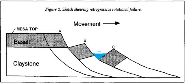 The major forces at work here is that the underlying claystone becomes saturated with water, softens, and erodes away until it becomes unable to support the much denser basalt cap on top. The claystone begins to slowly slip away carrying the cap with it. The “valleys” between the “ridges” trap water which becomes many of the lakes you can see from this view point. We would like to acknowledge the support of the rangers at the Grand Mesa National Forest Visitor Center, in particular the resident geologist, Mike Wiley, who first showed us the diagram above and answered our questions about what we were seeing. To gain this Earthcache You may log your find immediately but to complete the process you must answer the following questions and e-mail them at the same time to TEAM kekj . Please do not post the answers in your log: It will be deleted! 1. What is another name for “Slump Blocks” ? 2. How many major “steps” do you estimate you can see far off to the East? 3. What is the color of the rock on which you are standing? 4. Do you think the rock you are standing on is Basalt (Lava) or Claystone? 5. At which point on the sketch in Fig. 1 do you believe you are standing, A, B, or C?
Look for our nearby “Grand Mesa's Cap – Exposed” Earthcache (GC5D5FT) for more info on how the basalt cap got high up here! "Grand Mesa's Descent into Failure" (GC5D5FT) shows a very early stage slump block just beginning to form! Additional Waypoints P15DGGP - parking/trail headN 39° 01.741 W 108° 01.142
Add cache to watch list Log your visit Picture Gallery
Look UP, LOOK down, Look ALL AROUND (including behind you!)
GC34PHM Squirt (1.09 kms E) GC3XD8Q dominguez rim (36.38 kms SW) GC3XD9J palmers gulch overlook (36.56 kms SW) GC7Y5DE Evil Cache #1 (40.63 kms W) GC34PCR Horizon Multi (45.97 kms W) |
Driving Directions
6 Logs:
|