GCXYJN Unknown Cache Hiker's Delight
Type: Mystery | Size: Regular Regular | Difficulty: 4 out of 5 | Terrain: 4 out of 5
By: KingJR @ | Hide Date: 08/31/2006 | Status: Available
Country: United States | State: Colorado
Coordinates: N40° 30.760 W105° 29.815 | Last updated: 08/30/2019 | Fav points: 0
Takes more than an hour  Scenic view  Ticks  Not Wheelchair accessible  Parking available  Public restrooms nearby  Telephone nearby  Camping available  Horses  Medium hike (1km-10km) 
 Cache photos

JR's backcountry fire ring
Tahosa says "go north"
This is one tall tree
TURN AROUND
uh huh
Wilderness bounary sign


This cache is for those who like a good hike! Keep an eye on the regulations in the area, you are very close to the Commanche Peak Wilderness. THE CACHE IS NOT IN THE WILDERNESS AREA.
Knowledge of How to use UTM's and Maps & Compasses are essential components of this cache.

Footnotes on Compasses:
When using a compass in the field, it is very important to be careful when taking the measurement and when converting between field and map bearings. An error of five degrees in reading accuracy will result in a position error of about 150 yards after one mile of travel.
East Declination: The declination is East (9.5°). You need to make the two worlds equivalent by adding or subtracting the declination.

  • Map Bearing to Magnetic Bearing: If you are taking a bearing from one point on your map to another point on the map with respect to true north, then you are working with the map bearing. Now you want to figure out where your position is in the magnetic bearing. In order to transfer this information back to your magnetic bearing you need to subtract the declination from your map bearing compass bearing to create the proper magnetic bearing bearing. Map bearing - Declination = Magnetic Bearing.
  • Magnetic Bearing to Map Bearing: If you use your compass to take a bearing from your current position to a point on the landscape, then you are working with the magnetic bearing. Now you want to figure out where your position is on the map. In order to transfer this information back to your map you need to add the declination from your magnetic bearing compass bearing to create the proper map bearing. Magnetic bearing + Declination = Map Bearing.


This particular compass is especially helpful while using UTM.

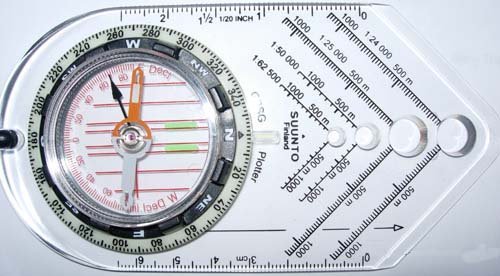
This is Suunto's GPSG Plotter compass.
Brunton's 8096 GPS Compass is also a very good compass.


Be prepared for a good hike to get to this cache. And bring plenty of water! This is a completly dry trail and has a southerly facing slope, so on the 95 degree days you can run out of water fast.

This trail does flirt with the wilderness boundary, keep an eye on where you are for what regulations you should be following. Two good maps to use are Nat Geo's #101 (big thompson) and #200 (RMNP). Both show the wilderness boundary.


The FTF gets a prize of six bucks. Original contents were 16 triangular pencils, 2 wooden rulers, 1 clip on pencil sharpener/eraser combo, 1 hot wheels 2004 Maserati Quattroporte, 1 60 count bandaid box, logbook and pen. Cache is a 50 cal ammo container with "Official Geocache" sticker on the side.


The main listing coordinate for this cache IS NOT WHERE THE CACHE IS.

To find this cache some real land navigation skills are a must. This is some rugged country that skirts the northern edge of the commanche peak wilderness area.


Okay here we go: There once was a cacher named JR.
He liked to Hike with a purpose. On this particular rainy August day,
he ended up wandering around the North West corner of the Glen Haven 7.5 min map.

When he stopped to shoot bearings with his declination adjusted compass
he found that he was
60 MAP degrees to X9073,
344.5 MAP degrees to X9945,
and 310.5 MAP degrees to the center of the 10890 foot tall mountain labeled Bulwark Ridge.
The map had what appeared to be a flat spot on the mountainside
so he stopped to fill out part of his hike report and have a snack.

Find where he took a break and you'll find the hiker's delight!

HAVE FUN AND BE SAFE!!


FTF: Denali41, 9-12-2006 - Congratulations!

Additional Waypoints

 Custom URLs

Add cache to watch list
Log your visit
Picture Gallery

 Hints

You really need hints??? Okay fine, look at the pictures that I posted. (double check the wording I used for the compass work!)

 Nearby Caches

GCAXBNC Many Thunders #3 - Rock Scramble (36.48 kms N)
GCAXBMQ Many Thunders #2 - Big Drop/Climb (37.13 kms N)
GC8XR7M Monday Morning Meetup 191 (37.56 kms E)
GCAXBM6 Many Thunders #1 - Beginning/End (37.69 kms N)
GC8Z9CD Sherwood's Forest - Friar Tuck (38.11 kms E)


Driving Directions

 Logs

10 Logs: Found it 9  Didn't find it 1  

Found it 07/15/2015 By Path Pacer
Whew, that was a bear! My "taped to the coffee table and using a kid's compass" solution wasn't very good -- I was 184' off! Obviously we didn't find it that way, despite searching for almost an hour. Thanks to Tahosa for his picture of the downed tree. Without that and the picture of the actual cache, I'd never have found it. Never did see any of the other clues. Took the multitool and left a large flashlight.
Signing the log (finally)

Found it 12/07/2014 By icezebra11
This was another KingJR cache that had been on my list to do for quite a while. Last week I logged Storm Mountain Multi and today it was Hiker's Delight. Actually I had tried this cache over two years ago but came up empty handed. Back then I had only been caching a short time. I had gone to Jax and bought a quad sheet for the area and did the plotting and intersection. I was confident I would find it but that wasn't in the cards that time. After re-checking my map work and scratching my head on how I could be off, I found out the quad sheet datum was NAD27 and I was entering it in my GPSr in WGS84. That obviously didn't work too well. Sometime after that I got National Geographic's TOPO! mapping software. Printing out and plotting on a map in the correct datum makes a world of difference. BigSmile I finally got around to making my second attempt at the cache today. It was a pleasant day on Bulwark Ridge with the temps in the upper 40s and some wind. I made my way to my GZ and after a little searching, studying the spoiler photo, and searching some more I made the find of the nice big ammo can! My plotted coordinates ended up being about 20 feet off from where I found it. Thanks KingJR for this wonderful backcountry cache. It surely delighted this hiker!!!
Hiker's Delight

Found it 11/03/2012 By jmuser
An excellent hike! Mrs Jollymuser gets the credit for the find. I need to take her along more often. She seems to be able to find caches very quickly. :-) The weather was perfect. Cool air with warm sunshine. Didn't run into any snow until we got most of the way up to the cache. Just an inch or so of crunchy stuff. No problem or concern. Had the entire trail to ourselves. Didn't see another soul. Grabbed two other caches on the way up. Been up this way a couple times before going after the Dessert. We took a massage therapy device thing that had a travel bug attached. We will move it along. Left a small USA styled multi-tool pocket knife. Cache is in excellent shape and ready for the cold wet stuff. TFTC!! :-)
Ready for winter!

Found it 08/08/2010 By akabumper
Nice cache- and nice exercise. We found it mostly using the visual cues from the spoiler photos- I had a hunch we where in the right area from looking at the map and reading the description, but we didn't make any precise measurements. I guess we lucked out, since we found the cache in about 5 to 10 minutes. We left a newly christened TB. TFTC!!
current photo of one of the spoiler views

my son near the cache location

Found it 08/30/2009 By sleuthers
All the sleuthers and TatteredShoes enjoyed this fun cache. I got confirmation of my calculated coords from the owner and found I was only .002 off (more by luck than skill I think). We still spent quite a while looking for the cache, however, as our GPS reception was a bit spotty and location was bouncing around a lot. Thanks for a delightful hike.

Found it 08/30/2009 By TatteredShoes
That was fun!! I made the trek up the hill with Sleuthers and spent a good bit of time searching for this one. I should have brought the pictures, but I found it without them. I've been wanting to do this one for a while and this was a great day for it. SL, thanks for getting me out for a delightful hike!

Found it 09/03/2008 By RDAD
Sure had a good time finding your cache. A fun challenge and a nice hike. TNLN and signed the log. Thanks for the great cache. RDAD.

Found it 08/28/2008 By cameltrekor
Nice trail up to the cache. The dog and I sure had fun. My projections were about 70 ft off and down the hill. I wasn't going there, so I turned around and there was the cache. Took pencil and biner, left wooden nickel, biner, geopin and GJTB. Thanks, it was a delite.
picture spot on the way

smokey view of the day

Didn't find it 03/08/2008 By greengineer
Made it up with Uberquandary, and well, it was a nice day for snowshoeing anyway! It would appear that there was still at least 3-4 feet of snow on the ground where we recognized the tree in the pictures that is due south of the cache. I think we may have given up too easily, as the page indicates "snow friendly" but we didn't feel like digging around in the snow so we called it a day and headed back down. We'll be back though!

Found it 11/04/2007 By ernie66
I did the math last week and did the hike this morning. It's a nice trail--nice and wide, sections of it are dead straight and most of it is a nice, gentle grade. It would be good for nordic skiing once the snow gets deep enough to cover the rocks. But, not much snow up there today--just a trace in shady spots from a recent shower.

I got to ground zero and found the cache after 5 or 10 minutes of searching. Thanks for the fun puzzle and great location! SL, TFTC!