GC1E9RE Traditional Cache 
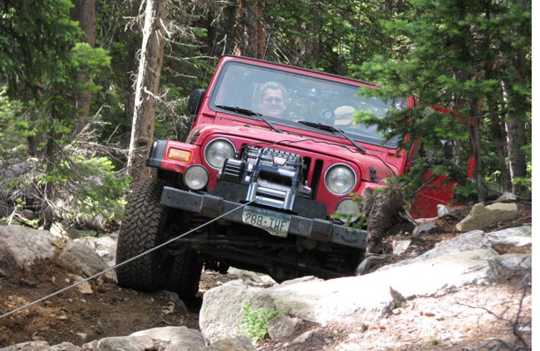
RM ORS #09-08: Got Winch?
Type: Traditional | Size: Regular Regular | Difficulty: 2 out of 5 | Terrain: 3 out of 5
By: The 2008 4x4 Event Pre-Run Gang @ | Hide Date: 07/19/2008 | Status: Available
Country: United States | State: Colorado
Coordinates: N39° 29.961 W105° 53.874 | Last updated: 08/30/2019 | Fav points: 0
Scenic view  Abandoned mines  Cliff / falling rocks  Motorcycles  Quads  Off-road vehicles 

RM (Rocky Mountain) Off Road Series (ORS) #9: Swan River/SOB Hill
A series by: RocketMan, n0wae, Grand High Pobah, zoltig, taylorsgeotracker, Joe Friday, Red Ruby, Mountain Roamer, DaToad and Team Teman

This is the first bonus cache and is the eighth of nine caches (7 plus two bonus caches) in the #9 series of Rocky Mountain off-road caches located along the Swan River Loop and SOB Hill. The Swan River Loop starts out from Tiger Road just outside of Breckenridge and is approximately 14 miles long. SOB Hill is another 6 miles plus the return trip distance that will vary depending on which way you go (see full trail description below).

Cache Information
From the Middle Fork Swan trail, take the trail heading south at N39 30.154 W105 54.076 (included on waypoint list below). Shortly after entering the trail, you will see a cabin on the left. Take a right turn at N39 30.080 W105 53.972 (included on waypoint list below) just before the cabin to continue up SOB Hill. At this point, it may not look like much of a trail but it is. You will come to the short difficult portion of SOB Hill shortly after making the turn. You will need a very capable off road vehicle to make it up this section of trail. The cache is at the top of the difficult section. If you just want to check out the section of trail on foot and get this cache, it is a short walk from the cabin.

RM Off Road Series #9 Complete Cache Listing (Doing the Loop Clockwise)

1. Grand Meadow
2. Amelia's Cache
3. Home Sweet Home
4. Red Cone View
5. Mountain Village
6. Over The River
7. Here's the Beaver

8. Got Winch?
9. Colorado Panorama

Trail Information

Rating/Description
The Swan River Loop consists of the North Fork Swan River trail and the Middle Fork Swan River Trail. The Swan River Loop is rated moderate. It is rated a 3 (easiest routes) to 4 (most difficult routes) out of 10 on the traildamage website. When the trail is dry, it can be done in most high clearance stock SUV's with low range 4WD. If the trail is wet or has snow, the difficulty rating can go up significantly.
Six of the caches in this series are located along the Swan River Loop. Disclaimer: You need to decide for yourself if it is safe to make the trip in your vehicle.

The two bonus caches are located along the SOB Hill trail which connects the Middle Fork Swan River trail to the top of Georgia Pass. This trail is rated difficult and make no mistake about it, it is difficult. It is rated a 6 (easiest routes) to 8 (most difficult routes) out of 10 on the traildamage website. You will definitely need a capable off road vehicle with a minimum of a lift, large tires and skid plates. To get over some of the obstacles, you may need lockers or a winch assist. Disclaimer: You need to decide for yourself if it is safe to make the trip in your vehicle.

This area is one of the more beautiful areas in the Front Range region. You will be traveling in areas that are over 12,000 feet in elevation with great views of the surrounding area. Mountain Goats are often seen at the higher elevations on this trail, so keep your eyes peeled for them.

The trailhead for the Swan River loop can be accessed from Tiger Road out of Breckenridge. To do the Swan River Loop in the clockwise direction, take Tiger Road to the North Fork Swan River trailhead at N39 30.792 W105 56.815. When you reach the top of the hill climb at N39 30.792 W105 54.166 you will be at Wise Mountain. Take a right at this intersection to check out the Wise Mountain cabin. From the cabin, return to the intersection and go straight to continue the loop. You will climb up a steep hill with the far left route being the easiest. At the top of the hill, you will come to one of the caches that is part of RM Off Road Series #4. At N39 31.376 W105 52.925, stay straight. If you go left, it will take you up Glacier Mountain and eventually down into Saints John Creek area. When you get to N39 31.251 W105 52.142, take a right to continue the loop. At N39 30.806 W105 51.748, take a right to head down the Middle Fork Swan River. When you come to N39 30.154 W105 54.076, a left will take you up SOB Hill. If you stay straight, you can complete the Swan River Loop, returning to Tiger Road at N39 30.383 W105 56.789. Taking a right here will take back on Tiger Road the way you started.

If you do take the side trip up SOB Hill to do the bonus caches, you will end up at the top of Georgia Pass at N39 27.478 W105 55.013. From there, you can either head South on the easy dirt road back to US 285, or you can head north down a moderate trail that will end up back on Tiger Road where you started.

Note: All coordinates in the above description are included on the waypoint list below.

Winter Months
This route is closed in the winter months and often will not be accessible until mid to late July. There is a section of the Middle Swan River trail that often is impassable until late in the summer season due to snow. You should call the Dillon Ranger District to ask about trail conditions.

Time/Distance
The Swan River Loop is approximately 14 miles and should take about 2 to 2.5 hours driving time. You will also need to include time for finding the caches, exploring, sight seeing, lunch, etc. If you add in the SOB Hill route, it will be about another 6 to 10 miles and will add another 2 to 2.5 hours driving time.

Trail Waypoints
See the waypoint list on the first cache here. (Running the Swan River Loop in a clockwise direction)

Additional Waypoints

TH1E9RE - SOB Hill Trailhead
N 39° 30.154 W 105° 54.076

W11E9RE - Right at Cabin
N 39° 30.080 W 105° 53.972

 Custom URLs

Add cache to watch list
Log your visit
Picture Gallery

 Additional Waypoints (2)

CodeNameTypeCommentsDateCoordinatesDistance
TH1E9RESOB Hill Trailhead Trailhead  07/21/2008 N 39° 30.154 W 105° 54.076 0.46 kms NW 
W11E9RERight at Cabin Reference Point  07/21/2008 N 39° 30.080 W 105° 53.972 0.26 kms NW 

 Nearby Caches

GC1E9RB RM ORS #09-05: Mountain Village (1.07 kms NE)
GC1E9R9 RM ORS #09-03: Home Sweet Home (1.93 kms N)
GC1E9RG RM ORS #09-09: Colorado Panorama (2.22 kms S)
GC1E9RD RM ORS #09-06: Over the River (2.25 kms W)
GC1EDPG RM ORS #09-07: Here's the Beaver (3.36 kms W)


Driving Directions

 Logs

5 Logs: Found it 5  

Found it 08/07/2015 By COpackrat
I was hiking and still could have used a winch to get up this... :-) Thanks for the nice ammo box!

Found it 08/30/2014 By CowwFace
Wife and Son went to this one w/o me while I helped a jeep that was stuck .... because he did not have a winch. Great hill to climb. It started to rain about 10 min's before we got to the hill, so it was wet and slippery. I've made it up in the RZR w/o a winch in the past, but today I did have to use the winch to get over one large step. Great cache Thank you.

Found it 08/15/2014 By Keep On Trekking
This was a really fun cache!! We parked our jeep at the fork, waded the river (two team members got wet feet), viewed the cool cabin and then made the steep climb to this cache. Just before reaching GZ, we could see some people and two jeeps parked at a level spot above us. They were preparing (mentally and with liquid refreshment) to make the descent. Then three more jeeps arrived.

This second group unloaded the kids and dog. Then we watched as two jeeps from the second group made the descent and then drove back up. These were rubicons and had 39" tires, They made the tortuous trail look easy. After finding the cache, (T: a couple toy dinosaurs L a few deco rocks and three red hearts. SL.), we started back down and watched as the first two jeeps negotiated the trail. They were Wrangler jeeps from Iowa and only had 32" tires.

Part way down as the first of the two tried to lift its tires onto a rock to straddle a bigger rock in the middle of the trail, the lifting rock moved. The jeep slipped and got hung up on its skid plate and all 4 tires were spinning, but not contacting the ground. But, they were able finally to get the jeep moving again and amazingly incurred no damage to their jeep. We spent an hour just watching the proceedings and took over 50 pictures. Thanks for placing a cache along this expletive trail. It was a fun experience.

Found it 08/21/2013 By <>
Spending our 4th summer in Buena Vista with a dozen or so of our Jeeping friends. We love to explore the roughest, toughest dirt roads in our red-mobile, and finding lonely caches in out-of-the-way places, 8 jeeps took a long day to do Red Cone, north along the Snake river to Montezuma, Up Saints John Creek, SOB hill and back south along Georgia Creek. 7 of our Jeeps are lifted Rubicons, so no winch today, although two of us popped off a couple of fender clips. Love to find caches that haven't been found in awhile. When I got to gz I thought Oh No, trees down all around. I couldn't beieve the ammo can was sitting under two trees and not a scratch on it. Thank you LORD. I'll be back another day when we can concentrate on finding other caches .tftc

Found it 08/15/2010 By gayleric
Tough Road!! But, nice cabin on the way and a pretty area. TFTC TNLN