RM Off
Road Series (ORS) #7: Deckers Rd./Goose Creek Rd./Stoney Pass
Rd./S. Buffalo Creek Rd./Redskin Creek Rd./Happy Top
Rd./CR-68
This cache is the second of seven in my
#7 series of off-road caches located along Deckers Rd., Goose Creek
Rd., Stoney Pass Rd., S. Buffalo Creek Rd., Redskin Creek Rd.,
Happy Top Rd., and CR-68. This route runs for 26 miles from
the start of Deckers Rd. near Deckers to Bailey on Hwy
285.
Cache Information
There is a short side
trip to get to the parking area for this cache. At N39 13.849
W105 16.883 (on waypoint list below), go left/straight to get to
the parking area at N39 13.370 W105 16.733 (on waypoint list
below). From the parking area, you will take a short .15 mile
hike up a few switchbacks to get to the cache. Please stay on
the trail as the cache is right next to the trail. Do not
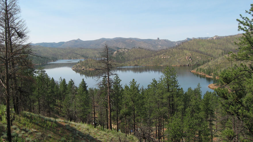
shortcut the switchbacks. From the cache location, there is a
great view of Cheesman Lake. After returning to the parking
lot, drive back to N39 13.849 W105 16.883 and go left on Goose
Creek Road.
RM Off Road Series #7
Complete Cache Listing (From Deckers to
Bailey)
1.
Beauty in the Burn
2.
Cheesman View
3.
Sticks & Stones
4.
Majestic Spruce
5.
Castle Mountain/Rock Face
6.
Rocky Point
7.
Sudden View
Trail Information
Rating/Description
This trail is the easiest one of any of my series to date. It
is basically just various dirt roads the whole way with the
exception of a couple of little stream crossings and a few slightly
washed out areas. When dry, the trail can be done in any
vehicle with decent ground clearance (4WD or 2WD). If the
trail is wet, it will be muddy and will probably require
4WD. Disclaimer: You need to decide for yourself if it is
safe to make the trip in your vehicle. All of these roads
only allow street legal vehicles, so no ATV's are
allowed.
The scenery along the route is awesome
with many cool things to see. The route starts out on Deckers
Road near Deckers. The road runs along the canyon wall until
you reach the junction for Cheesman Lake. Here you will make
a short side trip to get the second cache in the series.
After returning to the junction, you will go left on Goose Creek
Road and head to another junction where you will go right to get on
Stoney Pass Road. You will stay on Stoney Pass Road until you
reach Wellington Lake. There will be a couple of small stream
crossings on Stoney Pass Road. Near the North end of
Wellington Lake, you will turn right on S. Buffalo Creek
Road. S. Buffalo Creek Road has a few washed out areas, but
it is easy if you just take it slow. You will turn left on
Redskin Creek Road and then another left on Happy Top Road.
From Happy Top Road, you will take a right on CR-68 which will take
you into Bailey.
Note: None of the roads have signs with
the names, but coordinates for all of the turns onto the various
roads are shown on the first cache page,
Beauty in the Burn.
Winter
Months
This route may be passable in winter if all of the roads are
open. Wellington Lake is open in the winter, so the north end
of the route should be open in winter.
Time/Distance
The entire route as described above is approximately 26 miles and
should take about 2.5 to 3 hours driving time. You will also
need to include time for finding the caches, exploring, sight
seeing, lunch, etc.
Trail
Waypoints
See waypoint list on
Beauty in the Burn. (Entering from the Deckers Road on the
South end)
Additional Waypoints
W11420H - Junction for Side Trip
N 39° 13.849 W 105° 16.883
Go left/stright here to get to the parking area for this cache. Return here and go left on Goose Creek Rd. to return to the route.
W21420H - Parking Area for this Cache
N 39° 13.370 W 105° 16.733
 RM ORS #07-02: Cheesman View
 | Difficulty:
  | Terrain:
 Cheesman Lake View
;)