GC7RC9G Earthcache A River Runs Through It
Type: Earth | Size: Other Other | Difficulty: 2 out of 5 | Terrain: 1 out of 5
By: LolosDream @ | Hide Date: 06/17/2018 | Status: Available
Country: United States | State: Colorado
Coordinates: N39° 32.871 W107° 19.428 | Last updated: 08/30/2019 | Fav points: 0
Dogs  Takes less than an hour  Scenic view  Available at all times  Available during winter  Wheelchair accessible  Parking available  Public restrooms nearby  Telephone nearby  Bicycles  Stroller accessible  Food Nearby  Tourist Friendly 

At the posted coordinates you will find a kiosk sign titled Colorado's Geologic History in 7 Steps, which covers the brief history of Colorado Geology. This earth cache however will focus on a prominent feature and process that helped shape this entire region. 

GENERAL GEOLOGY OF THE GLENWOOD SPRINGS AREA 

"The scenery and topography that you will see while visiting Glenwood Springs have formed over billions of years through multiple episodes of mountain-building and uplift, widespread seas, swamps, down-cutting and erosion, dissolution, and collapse. The uplift of the White River Plateau to the north, folding of the Grand Hogback Monocline, deformation and subsidence of the Eagle Valley Evaporite, downcutting of the Colorado and Roaring Fork Rivers, Tertiary volcanism, and mineralized hot springs have produced the existing geologic environment in the Glenwood Springs area".

The town of Glenwood Springs is situated at the confluence of the Colorado and Roaring Fork rivers.

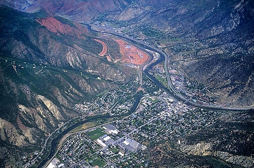
What you see around you is the present day topography of the area. Formation occurred through valley erosion, which was accelerated during the Pleistocene Ice Ages. The deposition of alluvium ( deposit of clay, silt, sand, and gravel left by flowing streams in a river valley or delta, typically producing fertile soil) and colluvium (sediment deposited at the base of a hillslope by un-concentrated surface runoff or sheet erosion). "Alluvial gravel terraces cover the eroded bedrock surfaces on the floors of the present day valleys. Along the edges of the valleys, colluvium and debris-fan deposits often overlie the terrace gravels". 

  
Source: 
Kirkham, Robert M. & Matthews, Vince. Guide to the Geology of the Glenwood Springs Area, Garfield County, Colorado. October 2000. 

To gain credit for this earth cache find, you must answer the following questions:

1. Look north across the river and observe the modern geopgraphy and geology of the area. What unique geologic feature to this area is harnessed for modern recreation? 

2. What major geologic process helped with the formation of what you see north east of the sign? 

3.  In what Ice Age did the process from question #2 become escalated? 

4. Looking at the hillside terraces can you observe colluvium or alluvium deposits? Why or why not? 

BONUS: Not required but can add to the fun, and prove you were on site to answer these questions. Please post a picture of you and/or your group and/or your GPS at GZ. Don't forget to smile! 


NOTE: If you post ANY answers to the questions above in your log (encrypted or not) it will be deleted. If you fail to send an e-mail within 7 days of your 'found' log, your log will be deleted. If you are caching as a group, only one e-mail needs to be sent. The person sending the answers MUST reference each individual in the group by caching name, no need to send 12 e-mails when one e-mail with 12 usernames will be sufficient.


 Custom URLs

Add cache to watch list
Log your visit
Picture Gallery

 Nearby Caches

GCWMXR Found Your Marbles (1.32 kms SW)
GC9W6K5 Rich Jebel Tree (26.58 kms SE)
GC13Q84 Tuckers Woodshop (39.59 kms W)
GCGA1Z Hays Creek Hunt (43.76 kms S)
GC2YKK2 Dorf's Cache (69.53 kms E)


Driving Directions

 Logs

10 Logs: Found it 9  Owner Maintenance 1  

Found it 06/18/2019 By HikingSeal
Last find of my wandering around town. Loses a little something without the information kiosk but it’s still a nice place to visit. Thanks for the cache.

Logged from Cachly
UTAG Member
Utah GeoTour Volunteer
Podcacher Club Member
Cachetur.no Ambassador and Contributor

Owner Maintenance 06/08/2019 By LolosDream
Informational kiosk reported as disabled. However earth cache can still be completed without the info from the kiosk. Road construction also reported in the area, you may need to walk or seek alternate route to GZ for the time being. Happy caching!

Found it 06/02/2019 By choromanskilynn
The referenced signboard is no longer there due to construction but we were able to glean the answers we needed. We saw a train coming into the station and loved watching the river. I think this area will be very nice when all done. TFTC

Found it 05/06/2019 By Diz&Dave
Greetings from the UK?. We are on our holidays!!! We are on a 12-day road trip around Colorado, Utah and Wyoming (a geocaching road trip from Denver to Yellowstone and back again), staying in Air BnB’s en route. 
Day 1: One cache near the first Air BnB to get us started
Day 2: Morning caching and dashing around Denver and in the afternoon headed out to the Mount Evans scenic route. Stopped off in Idaho Springs – fabulous Waterfall here, and then cache and dashed along the scenic highway, still snow ?on some of the higher ground. Ended the day with a trip to a TB hotel, in Downtown, and found 21 caches.
Day 3: Left Denver, collecting a few caches on the way to Colorado Springs. Made a snap decision to head out to collect some earthcaches , discovered the amazing Garden of the Gods and the pretty town of Manitou Springs, then headed West to pick up a few challenge caches, staged via the amazing Memorial park for a few more virtuals and ended on a traditional in the carpark near a pub. 
Day 4: A trip up to Pike’s Peak and then a slow cache and dash to Glenwood Springs (21 caches in total) and lots of weather ? . 
Day 5: Well today we took an unexpected detour. Set out early, undertook and earthcache in Glenwood Springs after breakfast and then decided to try to find a nearby 5/1 that had loads of DNFs, sadly we too had a DNF?, but did collect 2 other caches on the Rio Grande Trail . Then we set off for Vernal, and we had planned a caching route, and collected a few caches in places such as Rifle, but then sadly we lost all reception after a few miles (you’d think we should have learnt by now to download caches when we make plans), and we then accidently picked the wrong road out of Meeker as Google had also gone offline – both of us forgot to check the maps in the suitcases. So we detoured via Craig and met 2 lovely ladies in the information centre, who gave us a couple more maps and told us we had an extra 88 miles to the Dinosaur National Monument , we made use of the free wifi to download some caches we could collect on our new route. We then pressed on, dropped into the Dinosaur information centre (more free wifi) and then decided to head out to Harper’s corner, a lovey scenic drive (we saw 2 deer) and crossed into Utah and back. We took a lovely 2 mile yomp to see the spectacular amazing views and collect a virtual before heading back to Vernal, where rain stopped play, so we picked up a Papa John’s pizza and headed to the Air BnB for a cup of tea and a beer.

Lot of construction work taking place, no sign of plaque. Answers emailed to CO. 

TFTC ?

Found it 05/05/2019 By Huff-Suter
Day 2 of a 9 day road trip with my old caching buddy from Texas, Trea to travel and cache Colorado,Utah,Idaho and Wyoming. We are grabbing as many Earthcaches,Virtual Caches ,Puzzle Caches and challenge caches we can as we travel through each state. Today we will visit state parks..national parks and as many caches we can fit into daylight! Thanks LolosDream for placing this cache for us to hunt. We will post pictures and send answers as signal allows.

Found it 08/22/2018 By wildargs
We arrived at the panels under evening light. The "7-Steps" panel is a bit difficult to read, as the plexiglass is now stained, but we took time to decipher it all. We were on our way to Denver to visit family, but often stop here, for the trails, bike paths and scenery. Thanks!

Found it 08/20/2018 By wing6rider
We wandered down by the river and came across this EC. I think we sort of sorted out the answers from what we found? A beautiful spot to hang out. Answers sent to CO and here is a pic of me/w6r. Thanks LolosDream

Found it 08/18/2018 By CAT DUDE
found with march boys today

Found it 08/18/2018 By march boys
On the way home from Denver, had to stop and get this earth cache. tftec

Found it 08/13/2018 By fiercetara
Beautiful town