GC76GA6Owl Canyon: Buttes and Mesas
Type: Earth
| Size: Other
| Difficulty:
| Terrain:
By: Memfis Mafia@
| Hide Date: 05/30/2017
| Status: Available
Country: United States
| State: Colorado Coordinates: N40° 45.996 W105° 09.986 | Last updated: 08/30/2019 | Fav points: 0
When you arrive at GZ you will be able to observe a large formation on the south side of the road. This feature is either a butte or a mesa. The information below and some simple estimations and calculations should help you answer this question.
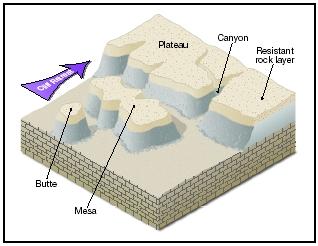
When traveling in the Southwest, you will discover plenty of the geologic and landscape features that end with the word butte, mesa or plateau — for instance, Coyote Butte, Grand Mesa, Colorado Plateau. In each instance, these geologic features have a flat top surface with relatively steep sides. So if they all have flat tops and steep sides, why aren’t they all referred to as buttes, or mesas, or plateaus?
In laymen’s terms, a butte is a small flat-topped or pointed hill or mountain. A mesa is a medium size flat-topped hill or mountain. And a plateau is a really big flat-topped hill or mountain. However, the true definitions are elegant and fascinating and encompass some of the most amazing landscape in the Southwest. Buttes are geologic features up to hundreds of feet high with steep sides, narrow pointed tops or very small flat tops. Buttes are what is left of what was once a mesa; the rest of it has been eroded away. Paria Canyon contains the spectacular Coyote Buttes Special Management Area. The notorious sandstone buttes (North and South Coyote Buttes) sit at the bottom of Utah’s Grand Staircase-Escalante National Monument and the upper section of Arizona’s Paria Canyon-Vermillion Cliffs Wilderness. The buttes and surrounding canyons contain a unique feature called The Wave, a multi-colored chute that has been cut into a sandstone mountain.
A mesa started life as a flat plain. Rivers and streams have eroded away the surrounding area, leaving a flat-topped mountain. Typically, mesas have much larger tops that a butte, and many feel that a mesa can only be called that if standing water can sometimes be found. The Grand Mesa is an outstanding example of this kind of feature. The Colorado River shaped the canyons to the north of the mesa, while the Gunnison River shaped the south side, leaving a large flat-topped mesa in between. The surface area of Grand Mesa covers more than 500 square miles.
The definition difference between a butte and a mesa most likely originated right here in the Southwest. Early settlers said that if you could find game on top, it was a mesa. Eventually that definition translated to the idea that if you could graze cattle (and find water) it was a mesa, not a butte.
A plateau is an area of land that with a relatively level surface raised sharply above the adjacent terrain on at least one side and the surface area of the top of the mesa can be huge. For example, the Colorado Plateau covers portions of southeastern Utah, northern Arizona, northwestern New Mexico and western Colorado. It covers more than 130,000 square miles (only four states in the U.S. cover a larger area). When the rest of the western United States began to rise or uplift some 10 million years ago due to continental drift, the Colorado Plateau region remained stable – perhaps “floating” on a cushion of molten rock. Though ringed by volcanic features, very few volcanoes, managed to penetrate into the interior of the plateau.
To earn credit for this Earthcache, please email me with the answers to these questions. Please do not include answers in your visit log.
Estimate the Size of the top?
Estimate the height?
Is it taller than it is wide?
Using this information, is this formation a Butte or a Mesa?
References
Mesa and butte. (2017). Retrieved May 30, 2017, from http://www.scienceclarified.com/landforms/Faults-to-Mountains/Mesa-and-Butte.html
Davis, George Herbert (1999). Structural Geology of the Colorado Plateau Region of Southern Utah, with Special Emphasis on Deformation Bands. G.S.A. Special Paper 342. Boulder, Colorado: Geological Society of America. p. 30.
Baker, David M. Morphological Analyses of Mesas and Knobs in the Northwest Fretted Terrain of Mars; Constraints on the Presence and Distribution of Ice-Facilitated Mass-Wasting. Ed. Alexander K. Stewart and James W. Head. Vol. 40. Issue 2. pp. 72. United States: Geological Society of America (GSA) : Boulder, CO, United States, 2008.
03/01/2019 By farrtom I drive through here often for work but finally had the chance to stop for the EC. At first I was looking at the formation east that also could qualify for the cache but I re-read the cache page and figured out which formation I should be looking at. TFTC - answers sent.
09/18/2018 By Jimmy63 Butte? Mesa? I'm so confused... Did I mention I live in Butte, NE Not Mesa, AZ... Lol SL... TFTC... :-)
09/18/2018 By J&LA Had quite the debate as to if it was a Butte or a Mesa. Used the suggested measurements to make an educated guess. We both called it the opposite designation, but we did enjoy stopping to check it out regardless. TFTC #3915
09/04/2018 By Casper&Aero Notre périple a débuté le 22 aoűt dernier et nous amčnera ŕ visiter douze états Américains et deux provinces Canadiennes... Notre départ s'est fait ŕ partir de Baie-Comeau, une ville sur la Côte Nord du Québec pour ensuite se poursuivre quelques jours ŕ Québec oů nous avons fait un peu de Géocaching.... Par la suite, nous avons fait un arręt ŕ St-Eustache et Ville de Laval, toujours au Québec, pour ensuite prendre l'avion et arriver ŕ Portland, Oregon... Nous avons fait un arręt le 28 aoűt ŕ Umatilla toujours en Oregon, le 29 aoűt ŕ Boise en Idaho, le 30 ŕ Twin Falls et le 31 nous sommes ŕ Salt Lake City pour deux jours... Le 2 septembre nous étions ŕ Rock Springs, Wyoming et hier nous avons fait un arręt ŕ Laramie, Wyoming... Aujourd’hui nous continuons notre périple vers Colorado Spring oů nous passerons deux jours...
Pendant tout le voyage nous avons ciblé quelques caches qui nous aideront ŕ atteindre nos objectifs personnels et nous découvrirons certainement de nouveaux endroits que les Géocacheurs d'ici voudront nous faire découvrir... Nous préparons ce voyage depuis plusieurs mois et savons que nous ne pourrons pas tout voir par manque de temps... Il y a beaucoup de caches mais devons fermer les yeux ne pouvant toutes les trouver... Mais c'est avec plaisir que nous apposerons notre signature sur certaines d'entre-elles...
Merci pour la création de ces caches qui ajoutent des sourires ŕ notre profil et qui nous font passer du bon temps peu importe l'humeur de Dame Nature... Notre log sera le męme pour toute la journée et s'il y a une particularité nous l'ajouterons au début du texte... Des favoris seront ajoutés ici et lŕ pour tout le travail accompli... MPLC
Casper&Aero de Baie-Comeau, Québec, Canada
Our English is not perfect, we use Google Translate to help us ...
Our journey began last August 22 and will take us to visit twelve US states and two Canadian provinces ... Our departure was from Baie-Comeau, a city on the North Shore of Quebec and then continue for a few days in Quebec City where we did some Geocaching .... Then we stopped at St-Eustache and Ville de Laval, still in Quebec, and then flew to Portland, Oregon... We made stop in Umatilla on August 28 still in Oregon, August 29 in Boise, Idaho, August 30 in Twin Falls and August 31st we are in Salt Lake City for two days... The 2nd of september we were in Rock Springs. Wyoming and yesterday the road brought us to Laramie, Wyoming... Today our trip will take us to Colorado Springs where we will stay for two days
Throughout the trip we have targeted some caches that will help us achieve our personal goals and we will certainly discover new places that Geocachers here will want us to discover ... We have been planning this trip for several months and know we will not be able to not all see for lack of time ... There are many caches but we must close our eyes can not find them all ... But it is with pleasure that we will put our signature on some of them ...
Thank you for creating these caches that add smiles to our profile and make us have a good time regardless of the mood of Mother Nature ... Our log will be the same for the whole day and if there is a particularity we will add it at the beginning of the text ... Favorites will be added here and there for all the work done ... TFTC
Casper&Aero from Baie-Comeau, Quebec, Canada
08/22/2018 By Trea Nice that there were 2 ECs so close together. Found this one with Huff-Suter, who sent in our answers.
08/05/2018 By 2lablovers Stopped for this on our way to Red Feather Lakes. Thanks for the interesting lesson. Lots of traffic on this road !
07/31/2018 By animjason I LOVE finding Earthcaches, so I was happy to see two so close to each other on my route to Batel Ranch. I was going there to help with the shooting range at a Youth Girl's Camp. They loved shooting the .22s.
I was surprised how busy this road was, especially with semis and double load UPS trucks. Glad this is a very wide road. Very cool terrain here, thanks for pointing it out. Answers sent.
Adding a photo too for good measure.
Thanks Memfis Mafia! Logged Owl Canyon: Buttes and Mesas from a ninth galaxy using c:geo!
~ Geocache Find #9952 ~
07/01/2018 By Mellowyellow2 Found it while in the area. Thanks for the information and we enjoy learning something new. TFTEC.
07/01/2018 By CanAmGuy We found this earthcache on our road trip to Yellowstone. Mellow Yellow2 and my two boys are here with me. Mellow Yellow2 will be submitting our answers. Beautiful place! TFTEC!
04/11/2018 By doglover&pups I have always taken Owl Canyon for a shortcut to I-25 from Laramie. Today I was on my way to Loveland to cache. Thanks for the interesting Earth Cache.
 Owl Canyon: Buttes and Mesas
 | Difficulty:
  | Terrain:
 When you arrive at GZ you will be able to observe a large formation on the south side of the road. This feature is either a butte or a mesa. The information below and some simple estimations and calculations should help you answer this question.