|
GC5VW4J
 Symbol Rock
Type: Traditional | Size: Small  | Difficulty:
  | Terrain:
  By: Denali41 @ | Hide Date: 05/19/2015 | Status: Available Country: United States | State: Colorado Coordinates: N40° 49.832 W105° 21.386 | Last updated: 08/30/2019 | Fav points: 0 


")

The Elliott ranch house and buildings were erected along Middle Rabbit Creek in 1910; the house was occupied for 42 years by John and Ida Elliott and by Miss Josephine Lamb, the area’s school marm who lived for this entire period with the Elliotts. On the north side of the ranch buildings and creek is a striking granite monolith that became John Elliott’s “symbol”. This peak has never been given a registered name by the USGS, but is now generally referred to as “Symbol Rock”. It’s an inspiring landscape feature that through the decades served as a stunning backdrop to the ranch and its activities. And today, long after the ranch’s abandonment, it provides an exciting scene for hikers and hunters who occasionally get to the Middle Rabbit Creek area. 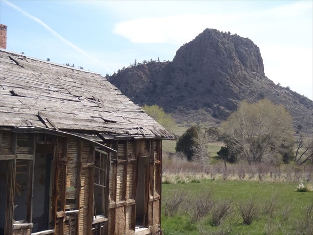 SYMBOL ROCK FROM ELLIOTT RANCH The cache is hidden at the top of Symbol Rock. The cache container is a jar that’s wrapped in silver duct tape. It might take some searching to find, so don’t give up. Most portions of Symbol Rock cannot be climbed safely without climbing equipment, but there are scrambling routes that can be safely ascended and descended if care is taken. The trick is finding the correct “easy” way up and back down–so study the terrain and choose correctly. If you make the right choice, the scramble is an easy one. Once on top find the cache and sign its treasure–the cache log. Bring a writing utensil. After your log-signing ceremony find a soft rock to sit on; then relax and admire the wonderful views from this “symbol”. Look down at the badly-deteriorated ranch house. Look east from the ranch ruins and see if you can discern the old school house where Jo Lamb taught kids from the few scattered ranches that occupied the Rabbit Creek drainages. Look south past the ranch structures to the “Twin Peaks”, as John and Ida and Jo called them. You’ll know which ones they are as soon as you see them! Enjoy your hike. Enjoy your rock scramble. Enjoy the enchanting scenery. Enjoy your new cache find. Be careful on your climb and the descent. Note: the cache is legally located in a State Wildlife Area that has seasonal access restrictions. The area is open to public uses (hiking, climbing, camping, horseback riding, wildlife viewing, geocache hunting, etc.) from May 2nd through August 31st each year. Between September 1st and May 1st each year, individuals entering the area are to be either hunting (deer, elk, rabbits, doves, dusky grouse) or fishing. So if you plan to find this cache during the period that’s restricted to hunting or fishing, be certain that you have an appropriate license and that you are also hunting or fishing. Hunting just for a geocache is probably not enough!
Add cache to watch list Log your visit Picture Gallery
GC3KR3X "Missing The Front Porch Again" (31.47 kms SE) GC75VKZ Tiger Cache (34.83 kms SE) GC8R77C Fossil Creek Cache (42.85 kms SE) GC883RB Emerson, LAKE, and Palmer (52.05 kms SE) GCW43Y Black Diamond Cache (94.76 kms S) |
Driving Directions
3 Logs:
|