|
GC2WCRF
 Potholes but no buffalo
Type: Traditional | Size: Small  | Difficulty:
  | Terrain:
  By: Roskoe52 @ | Hide Date: 05/16/2011 | Status: Available Country: United States | State: Colorado Coordinates: N37░ 36.239 W104░ 50.289 | Last updated: 08/30/2019 | Fav points: 0 


The park terrain except for the hogback is flat averaging 6425 feet of elevation. The hogback on the park north boundary gains 40 feet of elevation in the west and increased to 140 of elevation in the east. Much of the park ground cover is prairie and juniper prickly with scattered candelabra cholla. The park woodlands are primarily juniper and pi˝on. Exotic woodlands are cottonwood and Russian olive. The area west of Horseshoe Lake is partially marsh land with cattails and bulrush. 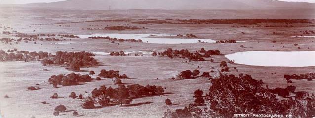 Image courtesy History Colorado. The image was photographed in 1885-6 by William Henry Jackson a distinguished Western and Colorado photographer in what would become the future Lathrop State Park. The two large potholes with water were joined together in the early 1900’s to form the current Horseshoe Lake that was originally naming Lake Meriam.. Image courtesy History Colorado. The image was photographed in 1885-6 by William Henry Jackson a distinguished Western and Colorado photographer in what would become the future Lathrop State Park. The two large potholes with water were joined together in the early 1900’s to form the current Horseshoe Lake that was originally naming Lake Meriam..Welcome to Lathrop State Park. We want you to have a good time walking our trails and hiking our terrain through grass, trees, cactus and rocks that may require using your hands seeking your geocache. Specific geocaches inform you of terrain that is more that a casual walk. Each individual geocache description lists a parking lot where you can start your walk, and that gives you time to see what this park is about as you seek your goal. Do not forget to enjoy the view of the mountains on the horizon.. Lathrop State Park, while sitting in the shadows of the Spanish Peaks, has the distinction of being Colorado’s 1st State Park and covers 1594 acres. One of the main features of the park is its two lakes; Martin Lake covers about 180 surface-acres while Horseshoe Lake has about 150 surface-acres. Both host a wide range of water activities. . Lathrop State Park is 3 miles west of Walsenburg via US Hwy. 160. Entrance to Lathrop State Park in Walsenburg, CO requires a park pass that can be purchased at the visitor center for display on your vehicle windshield. There is also a self-serving station near the park entrance.. Begin on Memorial Day weekend and ending on Labor Day weekend, each Friday and Saturday and Sundays’ during the 3-day holiday weekend a different illustrated or talks and props presentation is offered at the amphitheater. History, geology, and wildlife of the area are just some of the many programs presented.. Lathrop’s picnic areas, which received an outdoor recreation award for America’s Top 15 Picnic Areas, are situated around both Martin Lake and Horseshoe Reservoir. Each table sits lakeside or a short distance among the trees, has a stand up fire grill, and most tables are shaded. Picnic tables are first-come, first serve basis. Be aware that there are rattlesnakes in the park.. Two types of passes are available: A daily Pass is valid from the day purchased until noon the following day. An Annual Pass is valid at any state park recreation area for the calendar year. Colorado disabled veterans displaying Colorado Disabled Veteran (DV) license plates are admitted free without a pass.. Walking or driving Lathrop State Park you can see saucer shaped depressions that have no water. During a wet season in Huerfano County you may see a trace of water in some of these depressions. These are prairie potholes. Potholes form wetlands when enough water from precipitation is available. There are many lakes or ponds in the park. These are prairie potholes that were dammed many years ago. . Prairie potholes are depressions in the land formed thousands of years ago as a result of retreating glaciers during the last Ice Age. The great buffalo herds seen by the early explorers used pothole wetlands for water when they were not near a river. Potholes and wetlands away from the margins of continental glaciers were formed by geological processes and erosion. Mountain uplift was the main reason for Lathrop State Park and other Front Range terrain to have potholes and wetlands. In the cache description photograph taken by William Henry Jackson you can see that the potholes with water have no wetlands along the shore. The aridity of Huerfano County occasionally dries up the pothole thus not giving the wet land community time to develop. . Lathrop State Park is 3 miles west of Walsenburg via US Hwy. 160. Park your vehicle at the Lathrop State Park Visitor Center to begin your route to the geocache. . The geocache is 1 1/2 inch by 6 inch PVC tube with a removable cap that contains a log to validate your find and souvenirs. Your option to replace the souvenir you selected with one of your own of equal or greater value. You will be amazed at the pins, stilettos, needles and thumb tacks ready to determine your blood type. Be aware that there are rattlesnakes in the park. So, be careful out there! .
Add cache to watch list Log your visit Picture Gallery
The geocache wears camouflage. Indian summer begins to cool the heat of summer and many know that there is work ahead.
GCA8RPE under tree (2.52 kms NW) GC9TVTQ 50 state series #3: Arizona (70.27 kms N) GC9TVRM 50 State Series #2: Alaska (70.94 kms N) GC9TVQ6 50 state series #1: Alabama (71.87 kms N) GC9TVX3 50 state series #4: Arkansas (72.37 kms N) |
Driving Directions
11 Logs:
|